Whether you are relaxing on the front porch or enjoying the serenity of the outback from your 4×4, these cheesy damper pieces make for a great snack.
This article was first published in 4×4 Australia’s April 2011 issue.
This recipe can be cooked up with easily available ingredients without needing much utensils and serves 4 to 6.
INGREDIENTS – 3 cups self-raising flour – Good pinch salt – 1 bottle beer (350mL) – 3 dstspn oil – Fresh herbs of your choice (finely chopped) – ½ cup grated cheese
INSTRUCTIONS Measure flour into a mixing bowl, add salt, finely-chopped herbs and cheese. Combine ingredients and make a well in the centre of the mixture. Pour in about 300mL of beer and the oil. (You may need more of the beer, but see how you go and add more if needed.)
Mix together with a butter knife until all ingredients are combined. The dough should come together but not be too sticky. Tip the dough onto a floured board and knead gently.
Damper is not like bread and does not need to be kneaded very long (treat the dough as you would a scone mixture). If you knead it too much you will make it tough and the damper will not rise as much – the aim is to keep as much air in the dough as possible, not to knock it all out.
Pat out the dough into a large oval or rectangle shape and cut into squares.
Place the damper squares on a greased, large, tin plate and place on a trivet in a hot preheated camp oven. Bake until cooked, which should take about 10 to 15 mins. Don’t forget to have some coals on the lid as well, for an even cooking process.
The peak rising from the plains and segregated from the main hills and valleys of the Flinders Ranges has always caught my eye as I’ve headed north along the western edge of the ranges.
This feature was originally published in 4×4 Australia’s April 2012 issue
Mount Deception was named by Edward John Eyre in 1840 when he tried to pierce what he thought was a continuous barrier of salt lakes. It is the highest peak on the western side of the road and is immediately recognisable as you drive north towards Leigh Creek.
Until now the peak and surrounding country has been off limits to the general public, but with the historic Beltana Station now opening its doors to travellers, the Deception Range and a number of other spots on the property are accessible to four-wheel drivers.
Beltana Station was established in 1854, and the property soon became the headquarters of Sir Thomas Elder’s vast pastoral holdings. He was responsible for importing some of the first camels to Australia in the 1860s, and it was during that decade that many of the buildings on the property were constructed – many of which still stand today.
By the 1870s, the property was shearing over 20,000 sheep and was the base for a camel breeding operation that saw camels exported all over Australia. A transport business based around camels and extending as far north as Alice Springs and well into Queensland was also operating from here.
The station was the starting point for several important expeditions into the unknown interior and a large monument near the shearing shed commemorates the Ernest Giles 1875 expedition.
Today, Beltana Station – which incorporates the Puttapa Station lease – is 18,76km2 (460,000 acres) and is owned by Laura and Graham Ragless. While historically the property ran merino sheep, today beef cattle and meat sheep are run more and more, while tourism is ever-growing and an important feature.
Once you have a key and a set of track notes from the homestead, the track to Mt Deception is a relatively easy lope across the flat plains until you cross the rarely flowing Warrioota Creek. Rains some weeks before we arrived meant there was a trickle of water in the gravelly bed and even a few ducks and water hens scattered along the waterway.
The track then meanders among some thick scrub and you soon come to the ruins of the Tea Tree outstation before winding along a creek and past some giant river red gums. For people used to seeing these trees in the better-watered districts of western Victoria and the like, they may come as a bit of a surprise – but a pleasant one, as many birds and a few roos nearly always call the shady trees home.
From here the track begins to climb the range and while it isn’t particularly difficult, it is rough and rocky and a misplaced tyre could easily end up ruptured. As you get higher, the view extends to the west over Lake Torrens, but as you crest the top it is the bulk of the Flinders Ranges to the east that draws your attention.
The vehicle track ends on the edge of a sheer rocky gully while the highest point of the range and the peak of Mt Deception itself is a rough and rugged kilometre or so away to the north. Keen walkers could hike the intervening distance to the cairn on top of the peak, but the rugged country inbetween means it will likely take longer than you think!
We consoled ourselves with enjoying the view in all directions from track’s end and then returned to where we had set up camp in the pleasant camping area on Warriota Creek, just a kilometre or so from the homestead.
Next day we took a series of little-used tracks to the old 1889 Copper King mine and while this historic site can be reached via a Public Access Route (PAR) from further north, the route through the Beltana property is much more interesting. (UPDATE: the Public Access Route to Copper King is now closed to the public). At one point the station tracks take you to the permanent waterhole of Puttapa Spring; a beautiful spot to stop for a while, have a picnic, take a swim or simply observe the birdlife that comes here to drink.
The property also makes a great place to explore the nearby township of Beltana, which was once an important settlement for the nearby mines and the old Ghan Railway, but is now almost a ghost town. With some legs of saltbush mutton in the fridge (this is a meat lover’s delicacy – you’ve got to try it!) we headed off from Beltana Station and took the original route north through Puttapa Gap.
The old Ghan Railway also followed this route through a rock-shrouded pass in the ranges, and while the main road and railway now bypass this section of range country, it is the more scenic and enjoyable way north.
While our travels were to take us to other hidden spots within the Flinders Ranges over the next few weeks, we knew we’d be coming back to enjoy the delights of Beltana Station once more. And you’ll do the same!
Travel Planner
GETTING THERE Beltana Station is located about 500km north of Adelaide and 35km south of Leigh Creek. It is 6km east of Beltana Roadhouse and 4km west of the historic Beltana township.
ACCOMMODATION & CAMPING Accommodation is available in the wonderfully preserved 1860-built overseer’s cottage, or in the eleven comfortable and newly upgraded rooms of the shearers’ quarters. Camping is available within a kilometre of the homestead along Warrioota Creek. Toilets and hot showers are provided, as is a camp kitchen. More remote bush camping is also available.
4X4 TRACKS A number of self-drive 4X4 tracks are available, and these include the Mount Deception track, the Sliding Rock-Puttapa track and the 100km drive to the edge of Lake Torrens.
MORE INFO Phone 08 8675 2256 or visit beltanastation.com.au. For detailed info on this property and the whole of the surrounding area, check out Ron and Viv Moon’s latest edition of The Flinders Ranges, an Adventurer’s Guide.
Sometimes it takes remnants like great, rounded boulders in a deep gorge to signify that occasionally, water inundates what seems to be a dry, desiccated landscape. When those floods come, whether as gentle flows, or violent torrents, we should grab the chance to see it ourselves.
This feature was originally published in 4×4 Australia’s December 2012 issue
With this in mind, my wife Jan and I load the camper-trailer and head west out of Sydney’s urban sprawl towards a million square kilometres of dry red dirt, sand, corrugations and bulldust. After an overnight stop in Forbes, in central-western NSW, we make the 900km haul to Broken Hill.
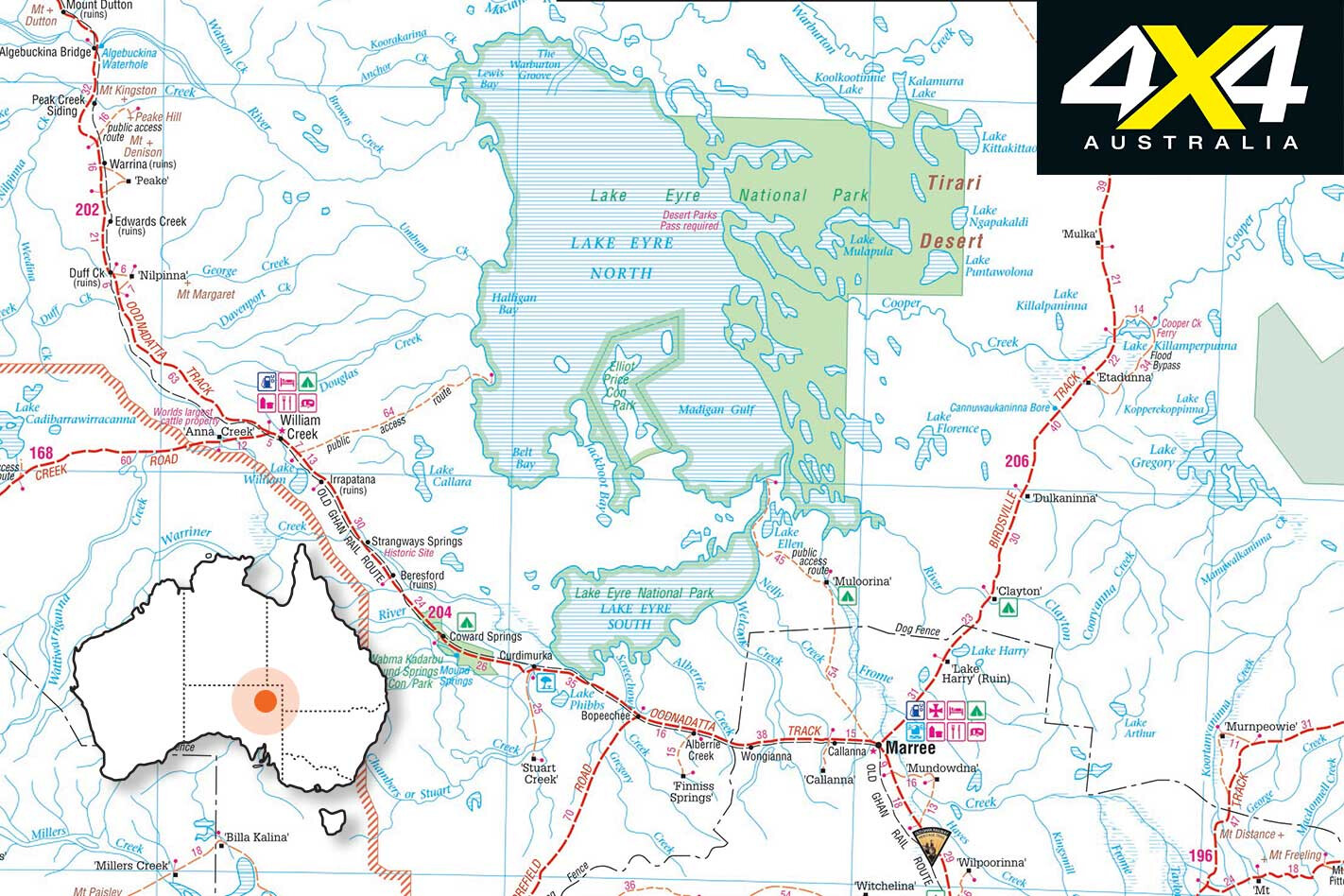
We reach the edge of the great Lake Eyre Basin, one of the world’s largest internally draining freshwater systems, covering 1.2 million km² – nearly one-sixth of the nation’s landmass. The next day, we continue west towards South Australia, plunging over the basin’s edge, where all streams now flow north-west towards the great lake.
The next day’s trip north, through Parachilna, Leigh Creek (for provisions), Marree and onto William Creek is a mostly easy 450km and gives us our first glimpse of water in south Lake Eyre from the trackside viewing area. When there’s water in this part of the lake, you know it’s nearly full.
We roll into William Creek at sunset, amazed at the growth in what had been a tiny settlement the last time we were here, six years ago. It’s still small, but gone are the old lights which controlled ‘traffic,’ allowing planes to taxi off the dirt airfield up to the pub. Now, there is asphalt on the landing strip, and a line of aircraft waiting to fly eager trippers out over the waters of the lake, 40km away.
The campground, once a bare strip of gibbers and sand, is packed with campers and lots of booked-out, transportable accommodation.
Here, we meet our friends from Adelaide, Phil and Lyn Pullem, who have the advantage of a plane – a two-seater CZAW SportCruiser. With most of the territory around Lake Eyre isolated, this is the best way to admire the immensity of the flooding, which we experience the next morning as we fly east over the sandhills and the gibbers.
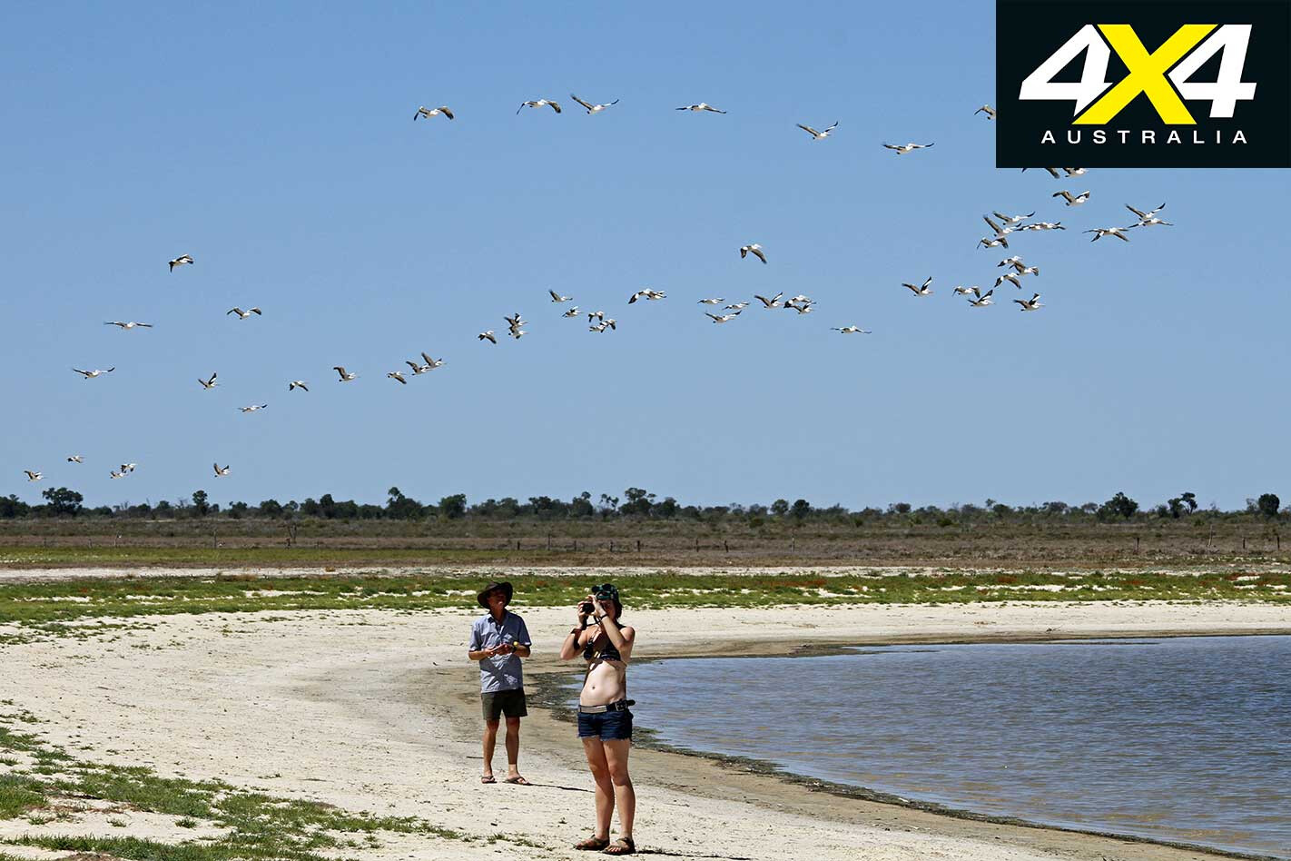
The scope of Lake Eyre can really only be appreciated when it’s full of water, but by the time we reach it (in September 2011) it’s a little down on its peak. Still, it’s an awe-inspiring sight as we fly in at high altitude, with water stretching almost to the horizon.
At times, it’s easy to forget where we are. Concentric rings of salt around the lake’s perimeter mark earlier highs and give way to the gentle greens and olives of the lake’s water, lapping around Belt Bay, Silcrete Island, Babbage Peninsula and Jackboot Bay. We might as well be cruising up the coast somewhere, not dodging updrafts in the heart of a desert.
On the eastern shore, the whole make-up of the lake changes. Pure pink rings line the bottom, produced by beta-carotene pigments from algae in the sediments. This continues right up the eastern shoreline until we reach the inflow of waters from the Cooper, one of the great arteries pouring life into the lake. After several circles of this area we turn back south-west, towards William Creek.
We spend several days at William Creek, before waving our friends home from the airstrip perimeter. After fuelling up – at $2.20 per litre – we turn back south, along the Oodnadatta Track, retracing our tracks. This time, we turn left off the track 7km from town to Halligan Bay, to camp on the lake’s edge.
A sternly worded sign on the way in reads: “This is a track, not a road” and warns that the track is not regularly maintained.
These potential safety issues are underlined as we pass a memorial for Caroline Grossmueller, the Austrian tourist who died here in December 1998. She had ignored advice to stay with her bogged vehicle, and had been overwhelmed by the harshness of the outback summer. Her body was discovered on December 17 – she reportedly had seven litres of water in two containers beside her.
On arrival we set up camp, then don gum boots, grab our cameras and begin a 100m walk across the mud to the water’s edge. Jan is disappointed by the lack of birds, with just a handful of gulls and one flock of pelicans flying over us. It seems the abundance of water this year means there is no need for them to travel this far inland.
We figure this will be a campsite that we’ll have to ourselves, but over the afternoon a steady stream of travellers arrive. A few stop just to snap photos, whereas others find a spot to camp – the preferred site just short of the defined camp area, from where the lake itself can be seen.
The next morning we are back on the way to the Oodnadatta Track and, yes, the sign was right; the Halligan Bay track is not often maintained and travellers have forged their own tracks to avoid the worst of the bulldust and corrugations.
We also stop at the ruins at Irrapatana, the old Overland Telegraph settlement at Strangways, Beresford train station and several of the Old Ghan Railway bridges before pulling into Coward Springs for our night camp. The warm waters of the spring are a welcome reviver after two days of hot and dusty conditions and the facilities, including the wood-fired water heater, are excellent.
It’s day nine as we head out in the morning, eager to inspect a few of the mound springs along the track, including Bubbler and Blanche Cup. These valuable water resources kept early explorers and cattle drovers alive in the 19th century, but many have now dried up as water pressure in the Great Artesian Basin has dropped following extensive drilling of bores.
At one point, we become bogged on a sandhill while driving off the track but soon dig ourselves out and are back onto the made surface and the strange wonders of Planehenge lead us into Marree. After a cold beer in an old pub, a fuel reload and stocking up on fresh provisions, we head north-east on the Birdsville Track.
Part of the appeal of this trip is to see where the flooding waters finish up in Lake Eyre, how it gets there and the impact it has along the way. The Birdsville Track and south-western Queensland offer many opportunities to see this, at places where the waters intersect tracks and roads.
The morning of day 10 takes us north from Clayton Station (54km north of Marree), across the Strzelecki Desert, past Dulkaninna and then down the turn-off at Etadunna onto the bypass track to take the ferry across the Cooper.
Two weeks earlier, following the end of the annual Birdsville races, there had been a 23-hour wait to get onto the punt, with travellers erecting tents on the track, setting up barbecues and enjoying a party as they awaited their turn. It set a new daily record of 111 vehicles, which was proudly scrawled on a piece of cardboard cable and tied to the frame of the ferry.
We have no delays and drive virtually straight on, then turn off to a parking spot on the northern side of the Cooper. Here, we marvel at this stream of emerald-green water flowing across the desolate tract between sandhills and over gibbers.
We drive down a winding track along the side of the 200m-wide stream, admiring the birdlife and taking in the extent of this water. It’s a steady, broad sheet of green water, quite fresh, if a bit earthy to taste.
Another 75km up the track, across the gibbers of the Tirari Desert, we stop at Mungerannie Roadhouse. It’s early afternoon and we get our choice of campsites and pick a narrow slot among the scrub bordering the wetlands. Just metres from the door to our camper will be a spreading sheet of water, with spoonbills, ducks, egrets, herons, swamp hens and black kites making the most of this oasis in a dry land.
However, as we are backing in, Jan notes an unusual sound from one wheel on the trailer and it quickly becomes apparent that we have a bearing problem. Over the next hour I remove and replace the failing bearing. Had we pushed on for Birdsville or somewhere further up the track, this would have been a real mess. We’ve caught it just in time.
After dawn on day 11, we hit the track again, across Sturt’s Stony Desert and over the sandhills on the edges of the Strzelecki and Simpson deserts and across the bird-rich, milky waters of the Diamantina River into Birdsville. What was once a true outback village is slowly urbanising, with new civic buildings, semi-urban developments, asphalt roads and creature comforts of civilisation. Even the Birdsville Bakery is now in a shiny new edifice, though the curried camel pies and lamb shank pies are just as tasty.
Heading south-east on day 13, we reach Quilpie, then cross Kyabra Creek and the Bulloo River before checking into Thargomindah’s camping ground.
This was one of the first places in the world – after London and Paris – to provide hydroelectric power for electric lighting, tapping subterranean heat for power. We check out an afternoon demonstration of this at the old power station – rumoured to be the oldest in the world.
On day 14, we head east to the opal mining town of Eulo, with an estimated population of “50 people and 1500 lizards”. We think they underestimated the lizards. Here, we get a glimpse of the narrow grasp some of these small towns have on survival, as the local store had burnt down two months earlier. Residents now drive 70km to buy food and fuel at Cunnamulla.
After a brief stop we traverse the Paroo River. Not far from the “mud volcanoes”, where gooey sediment from the edge of the Great Artesian Basin erupts through the surface, we turn south on the Dowling Track towards our next destination – Currawinya National Park.
This old sheep station is now a sanctuary for the bilby reintroduction into western Queensland, and for those seeking to experience the natural world in this rich semi-desert country.
The next day we head off to inspect The Granites, a poor man’s Devils Marbles, and then go on to the freshwater Lake Numalla and the saltwater Lake Wyara. While the former is nice but bare, the latter is a crowded multitude of pelicans. They spiral upwards on the thermals, and swarm noisily into the air at our approach.
Despite a local pub owner warning us the roads could be unsettling, we actually don’t find the next 220km to Bourke too unpleasant. But as we cross through that border gate into NSW, the watershed changes from the point where the rivers flowed north and west, and curves into the mighty Lake Eyre Basin, to where the creeks and rivers begin flowing south, towards the Darling. It is from here the water ultimately drains out into the Southern Ocean, almost 3000km away.
As we cross the deep channel of the Darling at Bourke, a modern highway overpass, skirting the charm of the old bridge alongside it, underlines our change of drainage basin. We travel another 90km west to Brewarrina and then 8km out of town we bear north-west for the 160km trip to Goodooga on what is the best dirt road we’ve ever seen.
A further 35km south-east takes us to the Castlereagh Highway and after another 28km, we swing into Lightning Ridge. Unlike other opal mining centres, Lightning Ridge is where all old trams, train carriages, car doors and cement mixers go to die.
There’s relatively little life underground, other than in the mines, but lots of ramshackle dwellings among the scrub. The one thing the Ridge does share with all other opal centres is the eccentric people it attracts, making it a must-see.
As we headed back home, we reflected on what we’ve learnt along the way – mainly that rain isn’t just a nuisance, but rather, part of nature, vital to our existence.
The Price of Pleasure
There’s a price to be paid for the pleasure of following our dreams with a 4X4 and camper-trailer.
Over a total of 21 days, we clocked up 6235km and used $1697 worth of fuel. Aside from the food we left home with, we consumed $658.30 in food and drink, which included the occasional ice cream and beer in outback pubs.
Camping fees cost us $317.60; broken down, this was a rate of about $10-$30 per night. These ranged from commercial camping areas – usually when we needed a shower and washing and wanted to tap into 240 volts for the night – to national parks.
Despite enjoying the facilities and resources in several national parks, there were no park entry fees. One (Clayton Wetlands) was on an honour system and we put $10 into the box.
We also had $104.90 in miscellaneous costs (a replacement wheel bearing, several loads of washing, a phone card for use in areas that were outside mobile range, etc.). In addition to this, we bought a full Desert Parks Pass ($143) before we left to ensure access to all our planned destinations in South Australia.
That’s a total cost of $2930.80, which these days isn’t too bad for a three-week holiday for two people. It equates to a touch over $900 per week, including all food, accommodation and travel.
Given the wonderful and once-in-a-lifetime experiences, we thought it money well spent.
THANKS to our mates at Ironman 4×4, a lucky 4X4 Australia reader has won $10,000 worth of Ironman accessories.
J. Jackson from Toowoomba in Queensland scooped up the $10K gift card after his name was randomly drawn from a pool of 14,200 entries.
“It took until the weekend for winning this prize to sink in,” Mr Jackson told us. “My wife and I are back in Toowoomba after two weeks in Hervey Bay, and I am sure I will gain more friends here once I reveal the prize I have won.
“I would like to thank the 4X4 Australia team for this prize. I have enjoyed reading the mag for decades now and have planned many four-wheel drive adventures on the articles written in the magazine – plus the product reviews make picking new gear a little easier. So, once again, thank you so much.”
To enter, all customers had to do was subscribe to 4X4 Australia to score 100 entries; enter a reader code found in the latest issue of 4×4 Australia magazine for 10 entries; or complete an entry form to grab a single free entry into the draw.
Hannah van der Sluys, Ironman 4×4’s social media co-ordinator, said: “A massive congratulations to J. Jackson, the winner of 4X4 Australia’s $10,000 Ironman 4×4 gift card. We look forward to kitting your vehicle out at our Brendale, QLD, showroom.”
We can’t wait to see Jackson’s four-wheeler adorned with quality Ironman kit.
Blink, then don’t be afraid to blink again, because this ain’t no ordinary 4×4 dual-cab ute. Yep, it’s a Y62 Patrol.
In fact, it’s the first Y62 dual-cab built and out on the tracks – a distinct departure from the ever-increasing number of Toyota LC200 dual-cabs doing the rounds these days. And yeah, we agree, chopping and changing a Y62 sure does seem like a crazy idea, but that view is easily dismissed when you see this bruiser in the metal – and listen to its passionate owner, Peter Thorpe, talk about what he rates as the ultimate all-rounder.
Not so crazy after all
Peter has owned – and raced – a raft of off-roaders over the years, swapping his behind-the-wheel tenure between earlier model Patrols and what he terms a short step to the ‘dark side’ of Land Cruiser ownership, before returning to the Nissan fold with the purchase of a Y62, a vehicle that, in standard form, he always admired.
“It is just the most underestimated four-wheel drive on the market,” Peter says. “Heaps of power, comfortable, big, roomy – all that sort of thing – and really, really good off- and on-road.”
So it wasn’t that long until things started going a wee bit wild. Peter came up with the idea of transforming the Y62 into a dual-cab rig, something that had never been done and wasn’t really thought possible.
His aim was to build an ‘all-rounder’ that would be equally adept at transporting him and his family on their regular camping adventures, as well as his own fishing and hunting expeditions – plus, it would see a lot of towing work. Encouragingly, his idea didn’t seem that far-fetched after he proposed it to On Track 4X4’s Andrew Cassar.
“I rang Andrew and spoke to him and said this is what I want to do,” Peter remembers. “No-one else has done one … while everyone else has had Land Cruisers cut and other things cut, nobody has cut a Y62 Patrol. He just said, ‘Yep, let’s do it’”.
Andrew laughs when asked about the question of transforming the Y62, jokingly referring to it as ‘the question I really didn’t want to answer’ but he reckoned it could be done. And, he knew the exact crew of specialists to entrust with the project, firstly checking with the engineer that he uses for his work at On Track 4X4 and then enlisting Les at Tinman Fabrications, who he rates incredibly highly, to firstly answer the ‘can it be done’ question, and then to do the actual cutting work.
Once he received nods of agreement he got back to Peter with the question of when he wanted to start, and the big build began.
Small steps, big gains
The Y62 is a high-tech, modern 4×4 with all the usual standard fitments these vehicles entail, and it was here that the team struck a few small problems, most notably with the air-conditioning system and the Patrol’s airbags.
The vehicle’s air-con ducts go right through the vehicle to the third-row seating at the back, which meant having to re-route them to ensure they finished at the back of the second row – and still worked as designed.
The next issue was the Patrol’s airbags, which meant designing a bracket that would retain the side-pillar airbag. On top of these two issues the re-wiring took a bit of time to figure out, again to ensure the vehicle would meet ADR and safety regulations after having its back half removed.
Trying to ‘trick’ the engine management system was a challenge, according to Andrew, with the vehicle still ‘looking’ for the tailgate, as one example.
Perhaps surprisingly, the actual cutting of the vehicle was straightforward, with Les removing the back section and welding the ute-back onto the body and finishing all the fabrication work – a top-notch job that Peter raves about in terms of the quality of the work.
Out the back
Upon the return of the now cut-down Patrol to On Track 4X4 HQ, the big Nissan was re-painted before Andrew got stuck into the rewiring and re-fitting of the interior.
Peter decided to also fully rewire the Patrol so as to accommodate all the power-reliant accessories that were to be fitted. This entailed fitment of a Redarc dual-battery management system and some tricky positioning of two auxiliary batteries (on top of the small auxiliary fitted in the crowded engine bay) in the powder-coated tray. The tray also includes a slide-out drawer at the rear for storage.
“With the Y62 there is not a lot of room for auxiliary batteries under the bonnet, so I have a small one,” Peter explains. “I had the tray designed with a false floor in the bottom that went underneath the tray to hold two extra batteries and a dual air compressor. I also had a [80L] water tank built into the head board.”
It is this use of all available space that adheres to Peter’s idea of creating a vehicle that could do double- or triple-duty, with the canopy a key component in making that work. The canopy was built by Will from WF Fabrications in Bendigo.
“He [Will] and I designed it,” Peter says. “He built it to the specs I wanted and had a few ideas that were good, so we just worked together and said this is how I want it. He said ‘how about this’, so we basically built it over a few months as I was in no rush.”
The canopy features a separate dog cage, along with another storage box (housing the ever-present 60L Engel fridge/freezer on a Clear View Easy Slide, as well as offering additional storage space), and a dual spare-wheel carrier setup, allowing the flexibility of use that Peter was after. The canopy is all-aluminium in construction, so doesn’t add excessive weight to the tray – and it’s easy to remove.
“You can just slide it off onto a bench,” Peter reckons. “I have a roller bench I slide it onto. It probably takes no more than five minutes to take it off. To put it back on takes about the same – it all just bolts back on and it is ready to go again.”
The sum of everything
It’s hard to draw the eye away from the immaculate finish of the metal-work on this Patrol, but there are plenty of schmick touring mods fitted.
The front end of the Nissan features ARB bar-work, (front winch bar with Warn winch, side-rails and side steps), as well as an ARB Intensity light set-up (spotties and light bar). A TJM Airtec snorkel keeps the V8 (fitted with a Unichip) breathing freely, while beefy Pro Comp XTreme MT2 315/70R17 rubber roll on Black Rock Crawler 17×8 steel rims.
Ensuring the Y62 walks the talk off-road, Peter has lifted the Patrol by two inches and fitted ARB’s BP51 remote-reservoir shocks (along with Airbag Man airbags in the rear), which have taken this experienced owner some getting used to.
“They take a little bit to get right I have noticed,” Peter says. “But I race vehicles as well, so I am used to King shocks off-road that are unbelievable and a lot more tuneable than the BP-51. But, once I have the settings right, the BP-51s seem really good off-road and soak up the bumps well.”
Underneath the tray Peter has fitted a 150L Long Ranger fuel tank to up the Patrol’s total fuel capacity to a lofty 290 litres. And he’s done this for good reason.
“It’s heavy on fuel,” he says ruefully. “If you sit on 100-105km/h it is really good – you probably get about 22L/100 – but anything around 110km/h and you are up around 26L/100…”
Yep, that is high, but it’s worth taking into account the fact Peter is running a larger tyre underneath a vehicle that, when you add a roof-rack and the weight of gear to the vehicle’s base weight, is a hefty off-roader to propel along the tracks.
“It would be nice if it was actually a bit better on fuel. Having said that, the price you can buy them for compared to a Land Cruiser, it can be up to a $30K difference [depending on model], so that’s a lot of fuel.” Plus he gets to listen to the sweet growl of that 5.6-litre V8 through the 2.5-inch custom exhaust system.
A more than happy result
The build for this unique bush tourer took around six months, with some additional time taken up with some final tweaking to the tray and canopy setup. Since then, the dual-cab Y62 has seen plenty of use, with Peter stoked with its overall performance.
“I am absolutely rapt with it,” he says. “I just went away for the weekend [at the time of writing] in it and it just outperforms anything I have ever had. It is just an amazing vehicle off-road; it has heaps of power. On the dirt, it’s just unbelievable how good it is. It just soaks up bumps and anything else … I’ve had heaps of vehicles – Toyotas, loads of other Nissans – but to be honest there’s nothing else that really compares to it.”
Even allowing for how stoked he is with the finished product, Peter still remembers that creating the first Y62 Patrol dual-cab, and one that looks like something that has just rolled out of a factory, meant a hell of a lot of work and time for himself, Andrew, Les, Will and all the others involved.
“People don’t understand with a conversion it’s not straightforward,” he laughs. “You’re not like these big manufacturers who pay engineers to sit on it all day and work out the problems; you’ve just got to hook in and do it yourself. Once you hit a problem, rather than jumping up and down … you’re better off just thinking ‘Okay, what are we going to do about it and what have we got to do’. Once you get your head around that’s the way it is, you’re laughing.”
And Peter can laugh; with good reason. Building a dual-cab Y62 Patrol – his idea of the perfect all-rounder – and being an integral part of that process, we reckon it’ll take years to wipe the huge smile off his face. He’s a lucky guy.
Anyone near Brisbane might look west for their next 4X4 adventure, but it is to the east, in Moreton Bay Marine Park, that a fabulous 4X4 holiday destination lies across two sand islands that will make you forget Fraser Island even exists.
This feature was originally published in 4×4 Australia’s December 2011 issue.
If possible, allow at least ten days to experience both Moreton Island National Park and North Stradbroke Island (Straddie). We suggest Moreton first so you start with full supplies and restock on Straddie, where there are more facilities. And remember the barge between the islands only operates Thursday to Monday.
Board the MiCat ferry and take the opportunity to lower vehicle and camper-trailer tyre pressures before disembarking at the Wrecks. The Wrecks campground is walk-in/tents only, while about 1.4km north Ben-Ewa offers vehicle camping.
Another option is to take the MiCat on its Tuesday run to Bulwer and camp at Comboyuro Point campground. A swim at the Wrecks beach is a must, with a protective artificial reef and breakwater just offshore, formed by 14 old barges and dredges sunk to provide safe anchorage for boats.
Middle Road consists of two one-way tracks bisecting the island. The western end is just 500m south of Tangalooma; travel east on Middle Road for 1.5km, then turn south on the Tangalooma bypass track (a sign indicates East Beach) for 3km. To the left is a 2km track to the Desert with a walking track to the dunes where sand tobogganing is permitted. It is another 6km to the beach – debris and soft sand drifts here make for challenging driving.
For experienced beach drivers in a convoy with recovery gear, a 12.1km run south to Big Sandhills is a great way to explore this part of the island. The Foreshore Flats begin 2.5km further. Explore the tidal pools at low tide before returning north.
At 0.8km north of Ben-Ewa, the 3.5km Cowan Cowan bypass track exits on the beach just past Cravens Creek (S27°06’40” E153°22’11”). Curtin artificial reef is offshore with good fishing and snorkelling. Bulwer is 4km north. This is basically the end of beach driving on the bay side of the island, although a wander around Comboyuro Point is worthwhile.
Middle Road is best driven from a base camp, since towing is not recommended on the soft sand (use the Bulwer-Blue Lagoon Road instead). From the east entrance of Middle Road, travel for 7.2km to the Mount Tempest turn-off. A track leads to a parking area with a 2.5km return steep climb to a lookout with panoramic views of the island.
For those who wish to camp on the windier ocean side of Moreton, the Northeast camping zone extends from Middle Road to about a kilometre north of Blue Lagoon. The Yellow Patch camping zone is west of North Point and the Southeast camping zone extends from Middle Road to Little Sandhills.
Behind the N2km marker is Eagers Swamp and Mount Tempest rising to 280m. The N6km marker is near the Bulwer-Blue Lagoon road; use it for the Blue Lagoon camping ground and both the Northeast and Southeast camping zones if towing a camper trailer.
Up the beach is a track to Blue Lagoon, a pristine freshwater lake. The N8km marker indicates the Blue Lagoon campground. Spitfire Creek flows across the beach near the N10km marker. Continue past the N12km marker to Braydon Beach. Stop at N14km (S27°02’24” E153°27’50”) for a picnic or a swim.
Afterwards, check the tiered track for oncoming vehicles, then make a steady run uphill along the wooden slats. After 1km, branch right for the Cape Moreton Conservation Park with the QPWS information centre, the Cape Moreton Lighthouse (no access) and a short walk to a lookout. This is the best place on the island to look for whales.
From the North Point carpark, turn left and drive on the beach for 1km, exiting on the left near the Yellow Patch sandblow, then turn right on the Bulwer-North Point road. Head west for 3.7km to a short walking track to the Five Hills Lookout providing views of the Heath Island. The Bulwer-North Point road ends after another 3km.
To the left is the Bulwer-Blue Lagoon road to the ocean beach, to the right is the road to Bulwer. Turn right and travel for 1.5km, and then turn left for 2.6km to Bulwer. The Bulwer bypass to the beach is the only way to get back to Ben-Ewa.
Make sure you are not caught on a rising tide, and drive south on the beach for 3km to the Cowan Cowan bypass track which runs for 3.5km and delivers you back on the beach just 0.8km north of the Ben-Ewa camping ground. Consider spending a few nights at Blue Lagoon; bushcamping extends from just north of there to the south of Rous Battery.
Time to take the Amity Trader from Kooringal? Plan your beach drive south around a low tide. There is no camping here, so take the barge when it is scheduled to leave.
From Middle Road, navigate south on the beach. Continue past S3 and S5; at S7km, White Rock is said to have good beach fishing. S9 is still in the Southeast camping zone, as is S11 in the Rous Battery area, where bore water is available.
About 1km south of S17 is the bypass track to Short Point and Kooringal; driving is only permitted to S19 and around the ocean side of Mirapool one hour either side of a low tide with a 30km/h speed limit.
The barge lands at Straddie’s Amity jetty. If you don’t have a beach permit to drive on Main Beach and Flinders Beach, pick one up at the Amity General Store on Ballow Street. Fuel and supplies are also available in Dunwich and at Point Lookout.
If you are bushcamping behind the foreshore of Main Beach or Flinders Beach, you’ll need to access a site no more than two hours either side of a low tide. You won’t be able to drive on the beaches at all one hour either side of high tide. Flinders Beach offers 200 designated, BYO-everything sites with four composting toilets.
The camping zone on Main Beach begins 7.5km south of the Causeway accessed via Tazi Road from Dunwich, from Fisherman’s Road off the East Coast road with a 7.5km beach run to the Causeway, or a 9.5km beach run from Point Lookout. This zone, with 400 designated sites, is ideal for those who want a quieter (though windier) camping experience. For more comfort, Cylinder Beach camping ground is within walking distance of Point Lookout and surf beaches.
Although most internal tracks are off-limits on Straddie (sand mining vehicles only) there is great four-wheel driving. From the Amity jetty, head to the north-west point of the island via Claytons Road and Sovereign Road; veer to the left just past Gore Street and follow the track to Flinders Beach.
Turn right (4X4 access is not permitted to the left), and stay keep the low- and high-tide markers. The camping zone begins at 2.5km, with numbered tracks running up from the foreshore. The Flinders Beach run ends at about 9km from the start (S27°25’18” E153°30’44”).
To access Main Beach from Point Lookout, proceed along the East Coast road and turn right on George Nothling Drive with 2.5km to the beach. To the left towards South Gorge is a great surf beach (no 4X4 access).
Turn right for the Main Beach 4X4 run. It is 2km to a deep, sandy, rutted track; turn right, continue for 500m then turn left on Fisherman’s Road to the Keyholes (about 2km, watch for deep potholes filled with water). Walk the short trail to the Keyholes, a pristine freshwater lake with superb swimming.
Return to Main Beach via the same route (S27°27’44” E153°31’38”). From there it is 7.5km to the Causeway, from which you can continue driving on the beach for another 24km to Jumpinpin. The beach widens into a dune system near where it ends with a spit that encloses Swan Bay. There is no access beyond this point. Return to the Causeway (S27°31’22” E153°30’09”) via Main Beach.
For the only 4X4 track accessible to the public, turn left at the Causeway and drive 500m before veering left to Tazi Road. The Tripod track enters after 2km on the right (S27°30’44” E153°28’47”). Expect tree roots running across the track, steep ascents and descents that may require low-range, and two-way traffic on a single-lane track.
At 6km from the start, several fire trails converge at Five Ways. Tripod track bends around to the left and then almost immediately branches to the right. At 8.5km veer right: Tripod Lookout offers views of Moreton Island to the north and Jumpinpin to the south. Tripod track ends after 11km at the intersection with East Coast Road.
Back on Tazi Road, about 1.5km west of the Tripod track, is the parking area for Blue Lake; this is Straddie’s original national park. Two trails enter the park with a 6km return walk to the Neembeedda Lookout, and the Karboora 5.2km return walk to Blue Lake (no swimming).
For freshwater swimming, continue on Tazi Road to the Brown Lake Recreation Reserve. At Point Lookout, a scenic walking track bends around the north-east tip of the island with access to Cylinder, Deadmans, Frenchman’s beaches and lookouts at North Gorge, Point Lookout and South Gorge.
Eventually, your time on these islands must come to an end. Time to head to Dunwich for the ferry to Cleveland. You’ll be planning your next trip to Moreton and Stradbroke islands the moment you leave. Both are, in short, unforgettable.
Travel Planner
WHEN TO GO Humpback whales migrate along the east coast of both islands from June to October. School holidays are always crowded.
WHAT TO TAKE BYO everything, including food, water, firewood, fuel stove, rubbish bags and a first-aid kit.
TRACK DIFFICULTY Plan all beach driving on both islands for 90 minutes either side of a low tide. There are no sealed roads on Moreton Island – expect soft, sandy tracks with deep ruts.
CAMPING Moreton has five campgrounds with toilets, cold showers and untreated bore water. Generators are not permitted. There are however five bush camping zones where generators are permitted. There are seven campgrounds on Straddie, all managed by the council. For information, including peak periods, phone on 1300 551 386.
FEES AND PERMITS Moreton NP camping and vehicle access fees must be paid in advance. Visit derm.qld.gov.au or phone on 13 74 68. Straddie camping fees can be paid at the campgrounds. Or, to book in advance, call 1300 551 253. A 4X4 permit is required to drive on Flinders and Main beaches.
Dramatic scenery, significant geological features and rich cultural heritage are just three of a long list of reasons to spend a weekend (or more) at Mambray Creek. Add to those the luxurious bush camping with hot showers and emus strolling past to say g’day, and you will never want to leave!
This feature was originally published in 4×4 Australia’s July 2011 issue
Mambray Creek is located in Mt Remarkable National Park, in the southern Flinders Ranges. Even though it is only a hop and a step away from the big smoke of Port Pirie, you have the feeling you are in the middle of nowhere, with nature right at your doorstep.
From the campground, you have the choice of six bushwalks, ranging from easy strolls to challenging treks. The 2.4km walk through Daveys Gully offers great views across Spencer Gulf to Whyalla. You will most likely encounter kangaroos, and the laughing kookaburra is never far away. The park is a birdwatcher’s delight, with 117 native species, including the brightly coloured variegated wren, Australian ringneck parrot and wedge-tailed eagle.
For the kids there is so much bush to explore, they will not tire of the place in a hurry. If you feel like jumping in the car, you can drive to Baroota Ruins, just a short distance from the entrance of Mambray Creek campground.
The ruins tell the story of the Baroota Run, established in 1851. After flourishing for 12 years, the area was hit by the big drought of the 1860s and thousands of sheep died. In those days, it was believed that the place could support 50,000 sheep, but, in reality, Baroota was only suitable for 2200 animals. Lessees struggled as overgrazing depleted ground cover, causing soil erosion.
The more adventurous should head out to Alligator Gorge, which is reached via a picturesque drive, commencing just south of Wilmington, on Main North Road. This steep road is unsuitable for caravans and large buses. There are two lookouts along the way, which are easily accessible and provide spectacular views across Alligator Gorge.
You can also traverse the full length of the gorge (allow two hours), but wear sturdy shoes as the gorge floor can become uneven and slippery after rain.
If you don’t feel like venturing out at all, there’s plenty to keep you entertained at Mambray Creek itself. It is a place of rest and relaxation, where you can experience nature up close – without even leaving your tent.
Like most people, you are bound to become addicted to this beautiful place, and you will find yourself back there one way or another; it’s remarkable.
Travel Planner
WHERE Mambray Creek is 45km north of Port Pirie, off National Highway 1.
CAMPING Set among majestic River Red Gums alongside Mambray Creek, this large campground offers 55 unpowered level sites. There is an amenities block with hot showers, flushing toilets and a baby change room. Wood fires are allowed in designated fireplaces. Take your rubbish home with you.
SUPPLIES AND FACILITIES Port Pirie and Port Augusta have all the big shops and supermarkets.
TRIP STANDARD All the roads at Mambray Creek are sealed.
CONTACTS AND INFORMATION DENR Southern Flinders District Office, phone 08 8634 7068. Email: [email protected].
RESTRICTIONS AND PERMITS You need a National Park Pass to visit Mambray Creek. These can be obtained online at parks.sa.gov.au or at the entry to the park. You will need to have the correct cash.
MAPS AND GUIDES Mount Remarkable National Park (Dept of Environment and Natural Resources).
Once upon a time any blow-by gasses produced by a vehicle’s engine were allowed to escape into the environment. As environmental restraints became more stringent, manufacturers fed those gasses back into the engine via the air intake.
That’s all well and good, but returning air containing oil and other impurities including water vapour into the air intake of the engine not only decreases the engine’s power and efficiency, it increases the carbon build-up in the inlet manifold and the EGR valve, corrodes turbo bearings and allows a layer of oil sludge to build-up in the intercooler, greatly decreasing its cooling ability.
That all adds up to not only a loss of power and performance, but increased fuel use, and it could lead to more expensive damage.
Some people propose that you blank off the EGR valve, but that is highly illegal and usually ends up costing you more in lost fuel efficiency. The way to stop that hassle and to maintain your engine’s performance is to fit an oil catch can.
As with everything you can get cheap, basic units that do a poor job, or something a little more expensive and complicated but a lot more efficient at removing those impurities from entering your engine.
The Flashlube Catch Can Pro from Terrain Tamer is a premium oil fume filter that filters out the damaging oil mist and condensation, helping your engine run like it was when it was new. The unit is made from a high-grade engineering polymer and glass-fibre compound so it is robust and can withstand the heat of an engine bay.
It is designed with 19mm inlet and outlet ports as well as pressure relief and vacuum relief valves to stop any over pressurisation of the engine and to maintain the efficiency of the motor.
The Flashlube Catch Can is fitted with a replaceable filter element, and these are reportedly much more efficient at collecting the oil fumes and condensate than stainless steel mesh filters. The Flashlube elements need replacing every 20,000km or so.
The unit comes with all the piping and brackets required and, while any handyman could fit this unit by following the instructions supplied, we had our unit fitted by the crew at Outback 4WD (www.outback4wd.com.au) in Bayswater.
The Catch Can will withstand a fair amount of heat, but it should not be mounted on the firewall, beside the turbo or exhaust manifold, or behind the radiator.
We fitted ours close beside the radiator at the front of the engine bay where it has a chance of cool air flowing around it, while the drain pipe runs down to the outside of the chassis rail where the drain tap is located and can be easily accessed. Yep, you have to drain the oil caught by the catch can, which is normally around 5-15ml of oil every 1000km or so.
The Flashlube Catch Can Pro may be compact in size, but it is good enough for all 4WD engines on the Australian market, even those fitted with a performance chip, an aftermarket exhaust and/or larger snorkel. The unit can handle flow rates of 250L/minute.
You should really fit one of these as soon as possible to get the best possible result, but with 110,000km on the clock of my Land Cruiser it is still a very worthwhile thing to do. While it isn’t completely ‘fit and forget’, it’s so easy to drain any captured oil that it is as close to hassle-free as it can get.
“THE customer is always right.”
It was this attitude that lead to the development of Isuzu’s MY18 D-Max and MU-X, with the Japanese company listening intently to customer feedback – namely from its I-Venture Trips – and making the necessary changes accordingly.
The big-ticket item revealed at the recent MY18 launch – and later tested at a waterlogged Mt Cotton Training Centre in Queensland – was the update to the D-Max’s rear suspension, often criticised by owners and the public for being rough and jittery on corrugated tracks. To this end – and in an Australian market first – IUA has taken the steps to correct this shortfall by replacing the five-leaf rear suspension with a three-leaf suspension set-up (all High-Ride Crew Cab excluding LS-M and SX Cab/Chassis).
Dropping from a five- to three-leaf spring softens the ride, making the D-Max more comfortable on not just long-distance outback roads but on freeways and suburban backstreets. The set-up utilises high-strength yet light materials, as well as a progressive spring rate. Larger rubber silencers are now also positioned between each leaf.
A day out at the Mt Cotton Training Centre, about 30 minutes’ drive from Brisbane, provided the opportunity to sample the all-new D-Max’s derriere back-to-back with the outgoing model.
The MY18 model feels nicely settled at the rear on undulations taken at a moderate click – 50-60km/h – with the rear feeling much softer than the relatively firm rear-end of the MY17 model. However, due to the short nature of the course, we will need a longer stint behind the wheel for a more comprehensive judgement.
A further update to the MY18 D-Max range has seen IUA increase the GVM of the entire range. The GVM on the new 4×4 range is now 3050kg, which has paved the way for IUA to also hike up the payload capacity of all models by 100kg in comparison to the MY17 line-up.
We loaded an MY18 D-Max with 600kg in the tray – putting it at 93 per cent overall capacity – and went for a quick squirt along a closed road circuit. The heavy load was barely discernible on climbs and when thrown through a chicane, but, again, a more comprehensive test will provide greater insight. So far so good, though.
Speaking of pulling weights, IUA learnt via feedback that more than half of its customers purchase a D-Max or MU-X for the purpose of towing. To this end, it has added Trailer Sway Control (TSC) to all new 4×4 models. TSC controls (ahem…) a towed trailer if any unwanted sway occurs – it does this by monitoring trailer movement through the ESC sensors and then modulating throttle and brake inputs to all four wheels.
We put this to the test on the closed road loop, whipping around in both an MU-X (towing a 1900kg caravan) and D-Max (towing a 1750kg boat). The brief tow test highlighted more than anything the competency of that 3.0-litre engine, as neither rig showed any sign of struggling to lug almost two tonnes of weight. TSC was harder to judge due to the simplicity of the circuit, though.
In other safety news, all MY18 D-Maxes are now equipped with a rear bumper and a reversing camera, but other safety features – including AEB and lane departure warning – are still a no-show.
IUA has also rejigged its D-Max line-up, with the LS-T now sitting atop the model range as the flagship offering. Priced from $54,700, the LS-T crew-cab 4×4 is only available with the six-speed automatic transmission and, on top of the LS-U, receives a bunch of additional kit: Passive Entry and Start System, leather-accented seats (a combination of perforated genuine leather and polyurethane leather, which provides improved comfort and bolsters support), six-way adjustable electric driver’s seat, roof rails, 18-inch alloys, a full-size spare and 255/60 R18 highway terrain rubber.
The LS-T has an improved payload capacity of 1024kg and a kerb weight of 2026kg. Towing capacity remains at 3500kg. It has 235mm of ground clearance and decent angles: approach (30.0), departure (22.7) and rampover (22.3).
Isuzu’s reliable 3.0-litre Euro 5-compliant turbo-diesel powerplant – good for 130kW and 430Nm – remains the engine of choice across the line-up, with Isuzu’s attitude seeming to be ‘why change a good thing’. We agree. In fact, Isuzu has more than 80 years of experience with diesel engines and has pumped out more than 26 million diesel donks.
As well as the addition of soft-touch leatherette throughout the interiors of D-Max LS-M, LS-U and LS-T variants, all of the USB ports – MU-X and D-Max – have been upgraded from 1.0A to 2.1A. Striking new colours – Magnetic Red, Cobalt Blue and Graphite Grey for the D-Max; and Magnetic Red for the MU-X – are now available for the Aussie market.
So while the D-Max still utilises a ladder-frame chassis and leaf-sprung suspension, it’s noticeably more refined and comfortable. And while most of the upgrades for the MY18 range centre on the D-Max, the MU-X remains a competent and comfortable off-roader.
At the recent launch IUA made clear its intentions to reach 30,000 annual sales by the year 2020 and, with an ever-increasing dealer base around Australia, the Japanese company is right on track to hit that target with a reliable and improved product.
The MY18 D-Max and MU-X will be available nationwide from May 1.
2018 Isuzu D-MAX pricing
| Drive | Body | Grade | Transmission | RRP (inc. GST) |
| 4×2 | Single Cab chassis | SX | manual | $28,600 |
| 4×2 | Single Cab chassis | SX | auto | $31,900 |
| 4×2 | Crew Cab chassis | SX | auto | $37,500 |
| 4×2 | Space Cab ute | SX | auto | $36,300 |
| 4×2 | Crew Cab ute | SX | auto | $38,700 |
| 4×2 | Crew Cab ute | LS-U | auto | $44,100 |
| 4×2 | Crew Cab ute | LS-T | auto | $46,900 |
| 4×4 | Single Cab chassis | EX | manual | $35,000 |
| 4×4 | Single Cab chassis | SX | manual | $38,200 |
| 4×4 | Single Cab chassis | SX | auto | $40,300 |
| 4×4 | Space Cab ute | SX | manual | $41,000 |
| 4×4 | Space Cab ute | SX | auto | $43,100 |
| 4×4 | Crew Cab chassis | SX | manual | $43,400 |
| 4×4 | Crew Cab chassis | SX | auto | $45,500 |
| 4×4 | Crew Cab ute | SX | manual | $44,600 |
| 4×4 | Crew Cab ute | SX | auto | $46,700 |
| 4×4 | Crew Cab ute | LS-M | manual | $46,900 |
| 4×4 | Crew Cab ute | LS-M | auto | $49,000 |
| 4×4 | Space Cab ute | LS-U | manual | $46,600 |
| 4×4 | Space Cab ute | LS-U | auto | $48,700 |
| 4×4 | Crew Cab ute | LS-U | manual | $48,800 |
| 4×4 | Crew Cab ute | LS-U | auto | $50,900 |
| 4×4 | Crew Cab ute | LS-T | auto | $54,700 |
2018 Isuzu MU-X pricing
| Drive | Body | Grade | Transmission | RRP (inc. GST) |
| 4×2 | 7-seat SUV | LS-M | auto | $42,900 |
| 4×2 | 7-seat SUV | LS-U | auto | $45,200 |
| 4×2 | 7-seat SUV | LS-T | auto | $48,900 |
| 4×4 | 7-seat SUV | LS-M | auto | $50,200 |
| 4×4 | 7-seat SUV | LS-U | manual | $50,400 |
| 4×4 | 7-seat SUV | LS-U | auto | $52,500 |
| 4×4 | 7-seat SUV | LS-T | auto | $56,200 |
Gear up and prep your 4×4 rig for the great outdoors with this month’s essential 4×4 gear.
Narva 4X4 LED work lamps
These three 9-36V multi-voltage work lamps have been engineered by the Narva team to withstand rugged conditions, while emitting plenty of light thanks to the ‘Cree’ LEDs. The 72358 lamp features five 3W LEDs for a total output of 1050 lumens.
The next model up – the 72364 – pushes out 1800 lumens, courtesy of its two 10W LEDs. The top-end 72360 uses four 5W LEDs to produce 2000 lumens.
Both the 72358 and 72364 produce a wide-spread, flood-beam pattern, while drawing minimal current. For those keen on a spot-beam pattern, the 72360 (current draw 1.6A at 12V; 0.7A at 24V) is the go.
The lamps are sealed to IP68 levels (waterproof to one metre) and are built tough; die-cast, powdercoated aluminium housing and polycarbonate lenses combine to ensure durability, backed up by stainless-steel mounting hardware.
Website: www.narva.com.au
Reese ratcheting cargo bar
Gear moving about in the back of your vehicle is annoying and can be dangerous. We always recommend tying down gear in the back, but this cargo bar from Reese would be ideal as an additional load-securing device, regardless of whether you have a pile of camping gear or the shopping back there.
The aluminium bar simply extends to the width of your cargo area (range: 1020mm-1780mm) and is then tensioned via a ratchet, with the rubber-capped ends ensuring you don’t scratch up the load area surfaces. Once secured, the bar will keep gear from sliding back and banging against the hatch/rear door area of your vehicle. It’s a simple design that is well-priced and works effectively.
RRP: $70 Website: www.reeseproducts.com.au
Terrain Tamer modified ratio gear sets
Available for a number of Toyota models, along with some Nissan and Suzuki vehicles, these new gear sets from Terrain Tamer offer an approximate 15 per cent increase or reduction in the vehicle’s transfer case ratio.
The Japanese-made gear sets (made using Terrain Tamer tooling) thus allow owners to adjust their vehicle’s gearing to suit the particular type of driving they do; opting for the lower-ratio set means a smoother, more controlled delivery of power and torque, ideal when tackling some low-speed rock-crawling or challenging climbs.
Going for the higher-ratio option means you get a drop in engine revs for more relaxed cruising on-road, plus improved fuel consumption. Toyota LC79, LC76 and Troopy owners take note!
Website: www.terraintamer.com
Projecta emergency lithium jump starters
Projecta has expanded its jump-starter range with the addition of two new models that feature lithium iron battery tech for enhanced performance. Both new models – LS950 (950Av 12V) and the punchier LS1250 (1250Av 12V) – include high-rate discharge lithium iron phosphate batteries that allow for up to 1800 battery cycles.
The LS950’s 950A peak amps and 290A clamp power make it powerful enough for jump-starting diesel engines up to 3.2L and petrol donks up to 6.0L. The LS1250 ups this with 1250A peak amps and 400A clamp power, suitable for diesel engines up to 4.5L and petrol up to 7.0L.
Both units can also double as power banks, via their included USB ports.
RRP: $290 (LS950); $395 (LS1250) Website: www.projecta.com.au
Pelican duffel bags
Pelican cases are globally renowned for toughness and durability, and the company has recently applied that DNA to the humble duffel bag, releasing 100L and 40L models.
The 100L features robust 1000-denier nylon that is water resistant, thanks to its DWR (Durable Water Repellency) coating. It also includes a water-resistant media pocket, a separate protective laptop pocket inside the lid, tough YKK zips all-round (with a water-resistant YKK zip on the external media pocket), convertible shoulder straps and additional ballistic nylon-coated, compression moulded EVA ‘impact zones’ on the bottom corners for even more durability.
The carry handles are padded, the main compartment has assorted pockets for additional storage, and it has a lifetime guarantee. The 40L is a shrunken version of the big-bopper model, with the same features. Both models include reflective Pelican logos, so you’ll never lose them.
RRP: $249.95 (100L); $199.95 (40L) Website: www.pelicanstore.com.au
Explore Australia by Camper Trailer
Respected travel journo and photographer Lee Atkinson has released this comprehensive guide to the best destinations for camper trailer owners.
Specifically focused on camper trailers (the first guidebook of its kind), the 352-page tome details some of the more remote campgrounds that can be found in national parks and along outback tracks. More than 320 camper trailer campsites (a mix of bush destinations, national parks, free campsites, station stays and caravan parks) are reviewed in the book.
The destinations are located in 50 regional areas and the information covers everything from local bushwalks and day trips, to fishing spots, bike trails and more.
RRP: $40 Website: www.hardiegrant.com/au