Part two – Trekking the southern cliffs
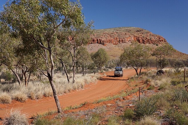
As we crossed the border into South Australia, the cliffs got lower and the many small coves and bays became more accessible, but the sand was softer and the scrub thicker. 4X4 Australia magazine’s trek across the Great Australian Bight continued, but not easily, as we soon discovered.
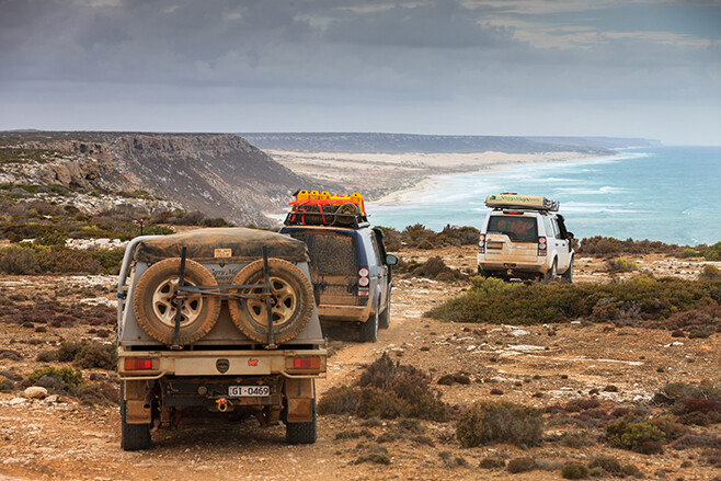
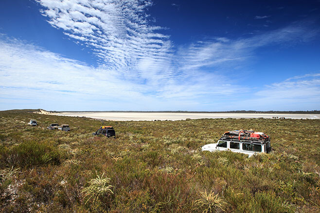
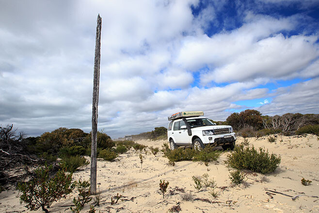
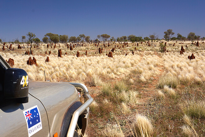
The long arc of beach swept away from our vantage point, its far end lost in the sea mist of mid morning, while the tall dunes of the Yalata Sandpatch morphed into the dull covering of clouds that stretched across the sky from horizon to distant horizon. We were standing on low cliffs overlooking Twin Rocks Beach at the Head of Bight, in the Yalata Aboriginal Lands, the whale watching facility that some people would know from this region, a few kilometres west of us.
We had permission to enter this normally closed area and run to the beach south from here to Hiltons, a camping spot that is normally the closest access to the beach. Hiltons, along with a few other selected sites further south, are popular fishing camps for those keen anglers trying their luck along this wild, surf-smashed coast. Access and camping is controlled by Yalata Land Management rangers and a permit is required to camp and fish this coast (see our travel planner).
Below us Eyre Well, and just a little further inland, Illcumba Well were hidden by small dense stands of low green scrub. Illcumba is one of the traditional waterholes and meeting places for the Aboriginal people, while Eyre Well was where the explorer Edward John Eyre found a life-giving soak for himself and his party during their 1840 ordeal of crossing the Bight from Streaky Bay to Albany.
We dropped down the rocky shaly cliff and poked our way between some prickly scrub and drove onto the seaweed-strewn beach. Above and around us whirled hundreds of small birds – mainly swallows – with more joining them as we drove along the sand, disturbing their early morning feeding activity. A large flock of terns lifted off the wet sand in front of me, swept out to sea in a big arc and landed on the sand again behind the last vehicle in our convoy. A dingo, trotting along the sand, looked back over his shoulder and on seeing us sprinted smartly into the dunes and quickly vanished.
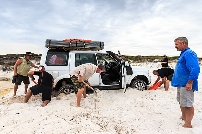
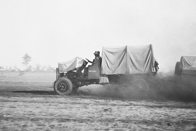
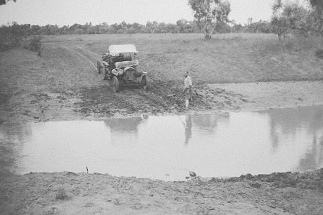
Our mid-morning enjoyment of nature and its delights quickly came to an end as the soft clawing sand slowed our wheels and taxed our engines. I thumbed the gear paddle down to second – low and growled along the beach trying to find an easy route, but the whole width of the beach seemed to be one and the same – and that was soft!
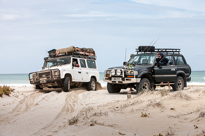
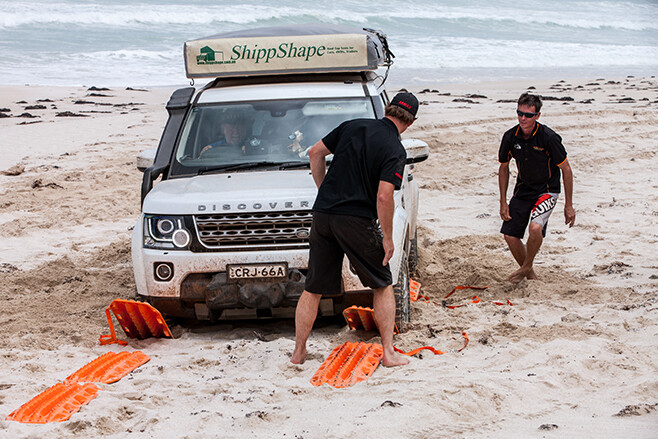
The chatter over the radio indicated a couple of vehicles bogged behind me and as I slowed even further I met the same fate. Slipping out of the vehicle we started a recovery with a few Maxtrax, a wave suddenly washing around the tyres of the Disco and the vehicle behind me. It’s surprising how everyone’s pace steps up a gear or two when waves begin washing around vehicles and for a while there was frantic activity with shovels and tracks until the vehicles were back up above the waves.
Then we went back and helped the others out – there being six other vehicles bogged along a 1km stretch of beach. Some were being snatched out by Ed’s hard-working Cruiser ute, or the worked-over 200 Series from Safari, while others were using a veritable highway of Maxtrax to get going.
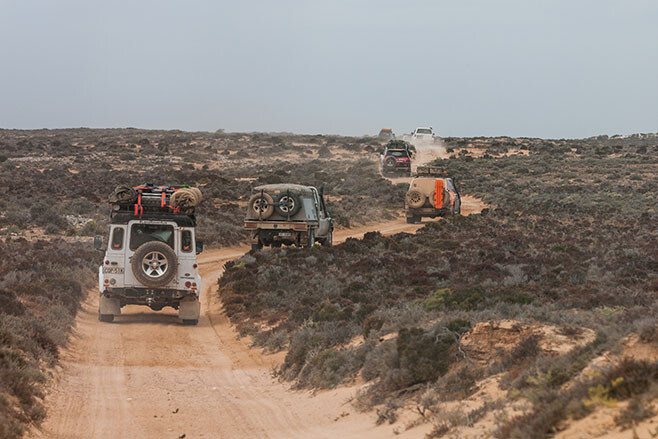
The next couple of kilometres along the beach was like that – growling engines with slow and tedious forward movement followed by a sinking feeling as one tried every trick in the book to keep the vehicle in some way moving forward. By now we were pretty well practiced and the Maxtrax were never far away; a bit of digging, a Maxtrax laid in front (or sometimes behind) each wheel and then a dab of the throttle to get up onto the top of the Maxtrax, before flooring the accelerator and heading for higher, drier or firmer land.
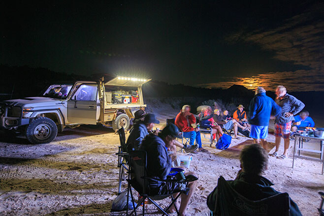
By the time we got to Hiltons everyone was glad to drive off that beach. We stopped and breathed a collective sigh of relief, sorted recovery gear and had a bite to eat and a brew.
We’d left Eucla a couple of days earlier after changing a few of the crew over, refuelling the vehicles and filling with water. The first day out from that small hamlet of civilisation was a big one.
The main highway hugs the cliff on the SA side of the border for quite some way and while the cliffs – the Bunda Cliffs along this section – are spectacular, the bitumen is at most a kilometre or so inland. We wanted nothing to do with the blacktop, so our track had first taken us through the small Eucla National Park to cross the SA/WA border at the cliffs above the Merdayerrah Sandpatch before we swung inland and picked up the old highway which strikes arrow straight across the Nullarbor Plain and through the rather unsurprisingly named Nullarbor National Park.
This good dirt road is in far better condition now than when it was the only route across the Nullarbor, which was realigned and bituminised on the SA side in 1976 – the WA side was completed seven years earlier. We travelled it a few times in the late ’60s and it was a horror stretch.
One of the things we did notice out here was that with the area becoming a park and the grazing infrastructure falling into disrepair, especially the water tanks and the like, the number of kangaroos we saw across these flat plains went from scarce, in the grazing lands on the WA side of the border, to absolutely zero within the park. We only again saw ’roos when we left the park further east.
We took the time to stop at the old Koonalda homestead, which now has a non-descript camping area nearby. For many of us the highlight of this visit was the graveyard of the hundreds of old vehicles that didn’t make it across the Nullarbor back in the days of the dirt highway. The homestead built in 1938, mainly from railway sleepers dragged from the Trans Australian Railway Line – 80km north – has been renovated by National Parks.
We also took the opportunity to head out to Koonalda Cave, 5km north of the homestead, which was once the property’s water supply. Entry to the cave is prohibited, but deep in its dark depths, ancient scratching by Aboriginal people, estimated to be 20,000 years old, have made this cave a very significant archaeological site.
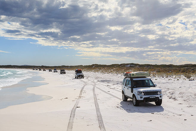
That night we camped just back from the Bunda Cliffs south of the Nullarbor Roadhouse, before heading to our meeting with the soft sand at the Head of Bight. Our route from Hiltons then took us behind the beaches along Coombra Track and through the Yalata Aboriginal Lands until we got to the track heading south to Dog Fence Beach.
This track, with deep bulldust patches in places, runs right beside the dog fence as it begins its journey north and then east through SA and along the SA/NSW and NSW/Qld borders to end in far away Queensland. Some say it’s the longest man-made object in the world and its job is to keep dingoes out of the more settled pastoral areas of south-eastern Australia. How well it does that probably depends on your point of view and whether you are trying to run sheep anywhere close to the fence.
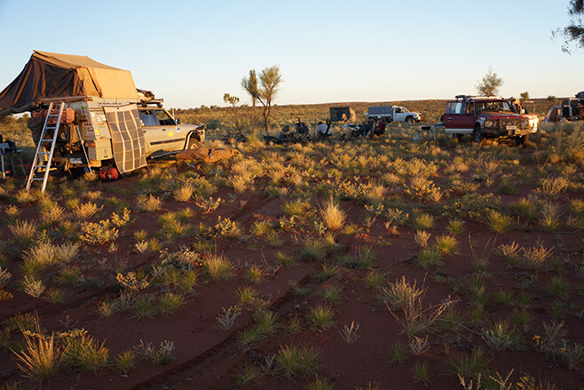
Our camp that evening was a beauty, tucked high on the edge of the Ocock Sandhills, just east of the fence. Dense scrub protected us from the wind, while the view took in a sweep of beach and lines of surf.
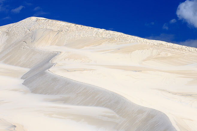
This is part of the near 400 sq km Wahgunyah Conservation Park which stretches along the coast from the Yalata lands to near Fowlers Bay. Behind the sweep of beaches, coves and cliffs the Ocock Sandhills run into the Wonginya Sandhills which transforms imperceptibly into the Chalgomnippi Sandpatch, making for one impressive mass of bare white dunes.
Next morning we followed a track deeper into this world of sand and windblown peaks and after a few kilometres came to a dead end where the beach south was being ravaged by a high tide. We tried to find a way through the scrub that bordered the dune system, but ended up backtracking a short distance where a track took us inland to some old ruins. Turning back towards the dunes, we passed Wahgunyah Well before again getting immersed in some thick scrub and tall stands of mallee trees. A storm had savaged the area sometime recently and we had to clear low overhanging branches before we broke out on a more open and easier track.
I’ve been through this section east of the Dog Fence three times now and never once followed my old route – in fact, I’ve never been able to find it. We have seen the ruins and the old well before, though; the shifting sands change everything as they push inland, enveloping tracks and scrubs in their relentless march north.
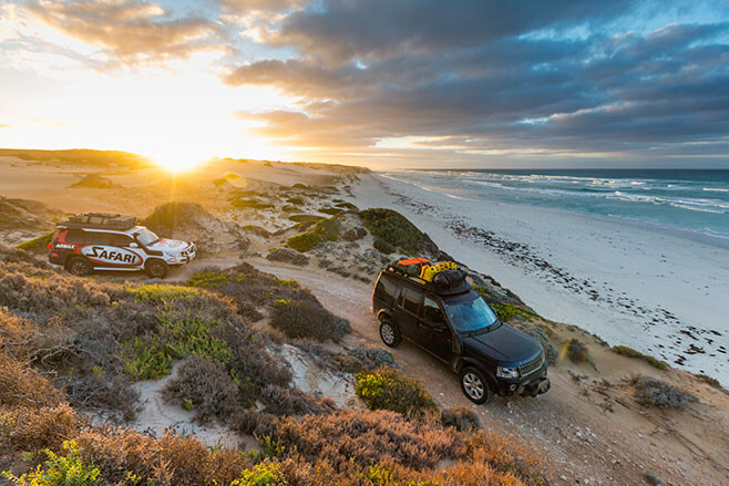
Time was slipping away so we continued east, stopping at spectacular Cape Adieu; like many places along this coast, it’s named by the French navigator, Nicolas Baudin, when he passed by in 1802. That night’s camp was at delightful Cheetima Beach and while there was nobody around apart from our group, we were out of the park and starting to get into more settled districts with grazing and cropping country inland behind the dunes.
We stuck close to the coast the next day as we headed to Wandilla Bay and then the protected Mexican Hat, before climbing Scott Point for a great view of the coast both to the east and west. Dropping off the headland we hit the sand at Scott Bay and cruised around the arc of beach ’til we found a track that cut inland over some very tall steep dunes. In this mini-Sahara of windblown sand we couldn’t help but have a short play – all for the cameras of course – before we slipped into the small village of Fowlers Bay.
Eyre had camped here in 1840 and after being resupplied by his support ship, set out to try and cross the Bight. He commented on the whale bones scattered along the bay, the result of this protected bay being used by the whaling ships of the day as a base for their operations. Today the bay’s main attraction is the nearby beaches and the town’s jetty which offers great fishing, day or night.
A day’s travel further east across rocky headlands, around salt mashes and some of the best surf beaches to be found in southern Australia, found us cruising along a relatively easy beach and cutting inland over some low dunes to a protected strip of sand on the southern side of Tourville Bay. In the southern half of the bay, tidal channels wind through a forest of mangroves, the most substantial of which is Davenport Creek, which just happens to have a strip of white sand along its southern edge. This is a popular spot for locals as the protected waters offer good fishing for whiting and flathead while the calm water is good for paddling a canoe or even for water skiing. You can camp nearby – but the mozzies can be thick, as we discovered!
From here we were back in civilisation, relatively speaking, and after a bush camp above the rocky shores of Point Brown, south of Ceduna, we cruised into the diminutive town of Baird Bay where we met with Alan and Trish from Baird Bay Ocean Eco Experience. This was the swansong for the trip with the couple offering one of the best, if not the best, wildlife experiences you can have in Australia.
Just offshore and reached by Alan and Trish’s specially built charter boat is Johns Island, now home to approximately 100 Australian sea lions. Alan anchored the boat just offshore from the island (the island is a conservation park and landing is not allowed) and the small beach that is the main nursery area for the sea lions.
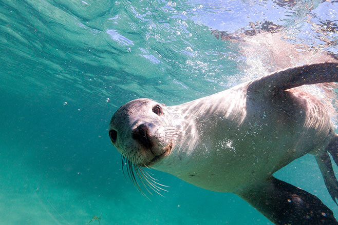
Within a minute a couple of young sea lions were around the boat and we slipped into the shallow water to join them. It’s about then you realise that humans are ungainly and awkward in the sea when compared to these delightful animals as they barrel-roll around you, swoop down to the sand just below you, look up enticing you to follow, then zoom up to your facemask and then barrel roll away to start it all again. If you don’t pay them any attention they’ll more than likely nibble on your feet or pull your hair, barrel-rolling away as you turn towards them. It is absolutely fantastic!
Part of this charter may include swimming with a pod of wild dolphins and while we did see a small group, they weren’t in a playful mood and left us floundering and alone in their wake. Luckily the sea lions are a lot more friendly and playful and while I’ve done this swim three or four times, it is one I’ll never get sick of.
That evening Macca cooked up a spaghetti marinara with the freshest seafood imaginable – what else could you expect when you are in the heart of one of the best seafood regions in Australia? It was a fine ending and a fitting celebration to our journey across the Great Australian Bight – surely one of the best, maybe the best, coastal 4×4 trips in Australia!
Want to see more from our trip? Check out the below videos:
- The Great Australian Bight adventure: part one
- The Great Australian Bight adventure coming soon
- The Great Australian Bight Adventure Teaser II
- The Great Australian Bight Adventure Teaser III
- Big Bight Adventure: Bush Mechanics
- How to prepare for a 4×4 trip
- How to beach drive
- How to 4WD in a convoy: radio communication
Part one – Trekking to the Border Cliffs
The strip of soft sand I was travelling on – more a narrow ledge than anything else and just below the first line of low scrub-covered ridges of sand – was becoming narrow. To my immediate right the jagged spires and clumps of sea-eroded limestone rocks didn’t look particularly inviting, while the wave-tossed sea a little further out was downright intimidating. Suddenly the sandy ledge I was on gave out completely and the Discovery lurched sideways into the sand and seaweed.
I thumbed the gearshift paddle back to second, the low-range box growling in time with the increased rumble from the V6 diesel engine. As forward motion came to a quick end, the response was a plume of sand thrown through my open door-window, covering us in a fine patina of powder and chips of seaweed. ‘Bugger’, I thought as I hit the window-up button.
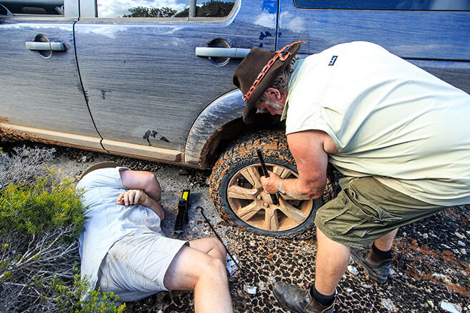
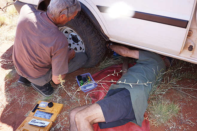
I clambered out the partly-opened door and surveyed the situation. It was only then that one of our group noticed the faint exit track through a low gap in the ridge of dunes 200 metres behind me. Around then the second Disco in our group copped a flat tyre; a victim of the sharp-edged limestone that lurked under sand and weed, waiting to catch out the unwary or the unlucky.
Neither location was a great place for a recovery or a tyre change, but you can’t choose the spot where the situation goes belly up; you just do the best you can. With a couple of MAXTRAX and a bit of digging I scrambled backwards onto more level territory out of the way of wind and waves.
We were glad to leave the beach and slink in behind the low dunes, the track winding this way and that as we pushed east, running parallel to the coast for another few kilometres before we could slip back onto a firmer beach with hard-packed sand.
Our trip had begun a week earlier when our group had met at the Pink Lakes Caravan Park in Esperance WA. And after packing food into boxes and meat and cool drinks into fridges we were ready to hit the beaches.
Starting at Esperance you can hit the sand right on the outskirts of town. From the wave-washed sand at the base of Wylie Head, a dome of granite rears upwards in an unbroken curve of unblemished rock. For first-timers it can be a daunting experience as you nudge your vehicle up to the rock-face and then, in low range, drive up the steep slope with only sky to be seen through the windscreen. Only moments into the trip and this climb is already on the list of highlights.
The view from the top, once you get there, is equally impressive, with crystal clear, light sapphire-coloured water washing up onto startling white sand. Further out from the beach the water goes through varying shades of blue to almost black. Dotted across the surface of the sea, rocky hump-backed islands rise above the water, their flanks alive and rippling to the wave-washed pulse of the sea. I’ve been here a few times and no matter the weather or sea condition, it is a sight that always holds me enthralled.
From the dome of granite we dropped down onto the sand of Wylie Beach and travelled the sweep of coastline all the way to Cape Le Grande, stopping to watch the antics of a couple of seals playing in the surf just offshore. Once we entered the Cape Le Grande National Park we were forced onto a section of bitumen that took us past delightful Lucky Bay which was worth a quick stop. It was then onto gravel roads to Rossiter Bay.
You can’t travel this long section of coast between Rossiter Bay and Streaky Bay, in South Australia, and not be aware of Edward J Eyre; the first European to explore this coast in 1840. His faithful native guide, Wylie, has his name perpetuated in the beach and headland we had just left. Rossiter Bay takes its name from the captain of the ship Mississippi, who by sheer luck was anchored in the bay when Eyre and Wylie staggered along this stretch of sand. It was one of the most fortunate meetings in Australian exploration history and the two tattered and worn explorers stayed on board Mississippi for 12 days repairing body and soul – and equipment – before continuing the gruelling trek to Albany, 500km west.
We had it a lot easier as we took to the sand and cruised north, but it was no walk in the park with clumps of seaweed and soft sand hindering progress. Deep gutters, now mostly dry but which had recently flowed strongly with fresh water, cut across the beach. In a moment of hesitation on which way to go to get around a particularly deep but dry crossing I chose the wrong line and, with a loss of momentum, got bogged down. It was to be the first of many boggings over the next couple of weeks as one by one we all suffered the ignominy of being caught out by the ever-changing sand.
That evening – after an especially difficult steep dune climb that wasted away the hours as we got vehicles over using MAXTRAX and snatches – we camped just back from the long sweep of sand at Membinup Beach.
The next day we took Poison Creek Road to where you can join the old Overland Telegraph Line (OTL) Track that strikes east through the Cape Arid NP.
Built in the 1870s, reminders of the OTL’s history are never far away when you drive this route across the Great Australian Bight. In fact, in places the lone wire that once carried the telegraphic signals of a nation lies along the track, acting something like a breadcrumb trail in your GPS and letting you know you’re on the correct route, east or west. At other times solitary poles from those bygone days (this OTL line closed in 1926 to be rerouted along what is now the Trans Australian Railway line further inland) can be seen, as well as the ruins of old telegraph stations.
We met a couple of park rangers along this track to Point Malcolm and discovered that, due to concerns about dieback which is plaguing many of the coastal areas of southern WA, this track through the coastal heath may soon be closed. That would be a great shame, but it is about the only thing that can be done to stop the spread of this lethal plant disease; Phytophthora dieback is an introduced plant disease that is fatal to over 2000 species of native Western Australian plants.
After camping that evening at Israelite Bay, with its nearby OTL station ruins, and checking the nearby northern beaches for our run north the following day, we opted to follow the OTL track for the first 30km or so before cutting onto the beach for the run north. Choosing such an option allowed us to drive the 50km or more of northern beach without one of us getting bogged or caught out by soft sand or deep seaweed. It was the only day that beach-driving good fortune smiled on all of us.
Our camp was reached quite early that afternoon as we pulled off the beach and wound our way amongst small hummocks of sand to stop at the base of the impressive range of sand mountains known as the Bilbunya Dunes. They may not be the highest sandhills in Australia but, at around 200 metres tall from base to razor-cut crest, they are far taller than the famous Big Red in the Simpson Desert and are far less vegetated. Their sinuous ridges of almost sensuous curves, sweeping upwards to a sharp-edged peak are mindblowing and so hypnotic that your eyes are always drawn back to them. You just cannot drive past them!
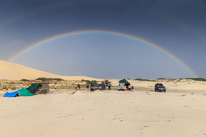
Suddenly the weather changed. We had pulled up in the early afternoon, the photographers and video team uninspired by the harsh midday sun, but then the clouds began to roll in. Within an hour, dark clouds surrounded us and we were amongst thunder and lightning. Then it began raining; first as solitary big, hard hitting drops, then in sheets.
Our campsite became a lake as we huddled under awnings and lean-tos while the rain poured down. Some of us even took the opportunity to have a fresh water shower. Just 15 minutes later a rainbow coloured the sky, the rain departed and the sun came out as it began to settle towards the western horizon. It was a magical performance in an unbelievable setting.
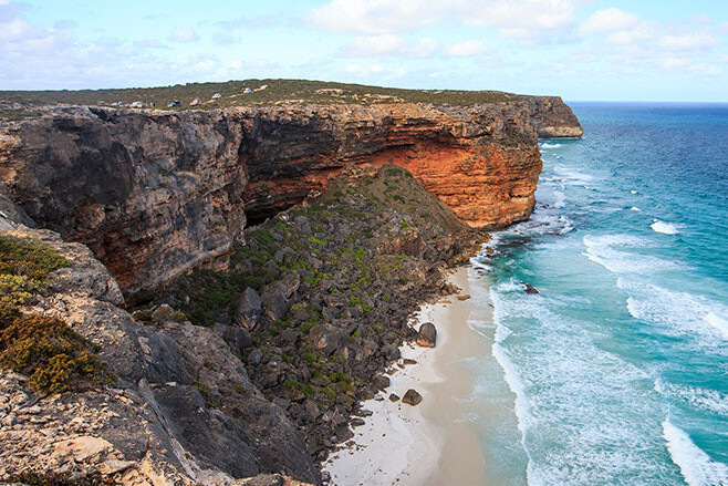
The cliffs of the Great Australian Bight start just east of here at Point Culver. A track climbs the Wylie Escarpment to begin its slow and tortuous way east either across harsh limestone outcrops or through mallee scrub.
Along a stretch known as the Baxter Cliffs, you pass miniscule Toolinna Cove. Further east, just inland from the cliff-lined sea edge, is a monument to Eyre’s friend and second-in-charge, William Baxter, who was killed here by natives.
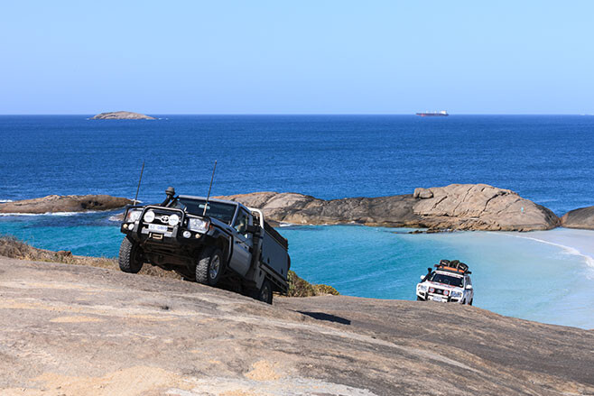
After two near full days of the horror of the limestone – as I call it – we began to wind through low-mallee-scrub-covered white sand dunes dotted with the occasional stunted native pine, and I knew we were getting close to the track that would lead us down the escarpment and onto the beach once more. The descent was easy and it was with a touch of relief we drove onto the sand proper, only to be reminded of our tyre pressures as the soft sand ensnared some of our convoy.
It had been a big day of 125km when we stopped for camp amongst some low scattered dunes at the base of the 70-metre high cliffs of Twilight Cove. This is a truly exquisite spot; in my opinion the most remote and dramatic beach you can reach by vehicle in South Australia. We spent a couple of nights here: it was a terrific place and it was a great respite from the constant jarring of the tracks.
Next day saw our convoy, and me in particular, slide off the lip of sand and become bogged, before creeping back behind the first line of dunes to continue or way eastward. We left the beach again at the Eyre Bird Observatory – once an OTL station and the only that’s still close to its former glory – and stopped for a short time to talk to the volunteer caretakers who look after the place for three months at a time. We also checked out the small but interesting museum.
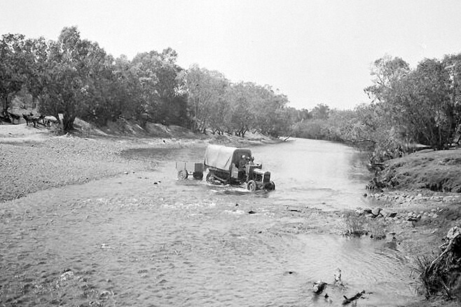
We picked up the OTL track again after leaving Eyre for an easy and enjoyable run east below the scarp that parallels the coast. We climbed the scarp at Madura and, with permission from the local stations, used the Old Coach Road and camped that evening on a saltbush plain west of Mundrabilla. Next morning we descended the scarp once more and headed out onto the Roe Plain, just behind the dunes, heading to Eucla.
The tides were way too high to tackle the beach east of Red Rock Point. Still, once east of the small tin-shanty hamlet of Wanteen we hit the beach once more in the hope of running the final section into Eucla. But the tide was still high and after playing silly buggers in the seaweed and soft sand once more, we took the easy way out and headed along the Starling Trappers tracks to civilisation – Eucla that is!
Camp was hot showers, cold beers and a great meal in the restaurant. Next day with a few of the crew changed over we were again to plunge into the scrub as we pushed east into South Australia. Some of the best beaches, hidden coves and rugged cliffs you can find on the planet were waiting – and we’ll share that with you next issue.
Want to see more from our trip? Check out the below videos:
- The Great Australian Bight Adventure: part two
- The Great Australian Bight adventure coming soon
- The Great Australian Bight Adventure Teaser II
- The Great Australian Bight Adventure Teaser III
- Big Bight Adventure: Bush Mechanics
- How to prepare for a 4×4 trip
- How to beach drive
- How to 4WD in a convoy: radio communication
Get the latest info on all things 4X4 Australia by signing up to our newsletter.
We called it O’Grady’s Well. It was the largest most outstanding native well any member of the party has ever found. Down this, holding on to ropes linked together, I climbed until it became too dark to see. Peeping ahead with a lighted candle I espied a little pool of water where the lubras had left off work.
So wrote Michael Terry in his book, Sand and Sun, regarding his visiting of this important native well, known to the locals as Ylalya, when he was exploring the remote areas of Central Australia in 1932. (See the feature on Michael Terry’s treks in 4X4 Australia, July 2015).
When a friend of mine, Willie Kempen, (long-time readers may remember his contributions back in the late 1980s and early 1990s of his adventures – he is still out there doing it!) said he had a Central Land Council permit to go to O’Grady’s Well, my hand was up like a flash to join his small group of adventurers.
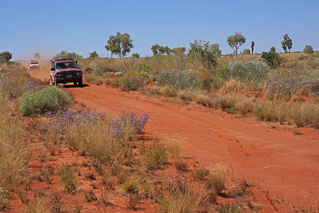
After meeting in Alice Springs a few weeks later, our five-vehicle convoy pulled into the community of Nyrippi in the heart of the Tanami Desert, around 360km north-west of Alice and 150km west of the main Tanami Road.
The route west from Tanami Road had taken us through Aboriginal land and we camped for the first night close to a spectacular but un-named gap in the Siddeley Range. From a vantage point on the hills we could see a line of peaks to the south-east jutting up from the surrounding flat sand plain. The most prominent of these peaks was Central Mount Wedge.
Our 1:250,000 maps also showed a waterhole nearby and after a short search we found it tucked up at the base of some cliffs in a fold of the range. Zebra finches flittered in from the nearby bushes for a speedy drink from the life-giving water, but that was the only movement we saw in this secluded spot.
The next day we passed through Newhaven; the one-time pastoral property that, some years ago, had been acquired by Birdlife Australia and the Australian Wildlife Conservancy. It’s now run as a conservation park. Camping is allowed on this remote property and bird watching is encouraged, but we pushed along past a sign that read: ‘Private track – use at your own risk’.
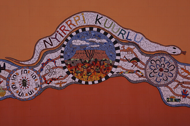
Quite suddenly we arrived at Nyirripi, a community of around 150 people – although at most times there are considerably fewer inhabitants. We found the well-stocked store and fuelled up with diesel for the vehicles and chocolate bars for the people.
We also met a number of traditional owners who gave our trip their blessings and allowed us to photograph the spectacular mural that graces the local school. We were also told that they were hoping to set up a small tourist campground among the spectacular peaks to the south of the community.
That evening, after travelling on little-used tracks from Nyirripi, we were skirting along the edge of Ethel Creek on a track that was about to vanish completely into the surrounding grass and spinifex. Amongst this verdancy we had trouble finding a campsite free of vegetation.
When we finally set up camp, disaster almost struck when a small campfire licked flames into the nearby grass and fire erupted quickly around us. A hastily grabbed bucket of water, a couple of fire extinguishers and a fire blanket had the flames under control, but it was a near thing and a valuable lesson on how quickly disaster can strike out here.
Next day we turned off the track, struck west and followed the wheel marks left by a group of traditional owners and aboriginal rangers who had been out to their traditional lands. We soon left these ephemeral marks as they swung north to areas we didn’t have a permit for.
The first few kilometres further west, over flat grassy spinifex plains and between, what at first were, widely spaced dunes, was easy going. Our plan was to head west and cut south of the McEwin Hills – an area our permit forbade us to visit – bypassing them by at least a kilometre.
The vegetation soon changed, subtly at first with the spinifex clumps getting bigger and the waving fronds of seed heads taller. We passed through a band of thick low verdant scrub of spindly wattle, dense cassia and emu bush. Rain had fallen across much of this country a couple of months previously, so in places amongst the scrub and spinifex were splashes of brilliant colour from myriad daisies, flowering honey, rattlepod grevilleas and corkwood hakeas.
We’d swung south to the edge of a dune as we tried to get away from the thick scrub, when a call over the UHF told us of the first puncture. A quick plug repair and we were off again, but we’d driven less than a kilometre when our little convoy growled to a halt with another radial tyre whistling to empty.
Both Willie and I, who were up the front busting scrub, had previously fitted our Patrols with tough MRF cross-ply tyres, while those following us were driving on radials. Certainly the MRF tyres are a dog of a thing to drive on bitumen roads, but out here in untracked country they’re worth their weight in gold.
At one stage, Willie’s Patrol smashed into a conglomeration of dome-shaped limestone rocks hidden by the thick grass and spinifex. These outcrops, which may cover an area of many square metres, are by all accounts the remnants of ancient mound springs (the main structure of the spring having eroded away). They are hell to hit unexpectedly in a vehicle and it was lucky that Willie’s tough old Patrol bounced its way through relatively unscathed.
That evening we pulled up in a large cleared patch of sandy plain for our night’s camp. Dotted across the sand were scattered clumps of daisies, common firebush, purple parakeelya and the muted pastel colours of mulla mullas. A few taller grevilleas and hakeas, plus the odd drooping desert oak, completed the scene and made for a very pleasant camp.
As we approached the Sandford Cliffs early the next afternoon, thick bands of scrub thwarted our progress – at times we were even driving blind with scrub taller than the windscreen hindering our way. Suddenly we were amongst large clumps of tea-tree, with the spinifex giving way to grassy tussocks. It was much easier going here and it was also a sign of better-watered country, as the water from infrequent storms ran off the rocky slopes of the nearby Sandford Cliffs.
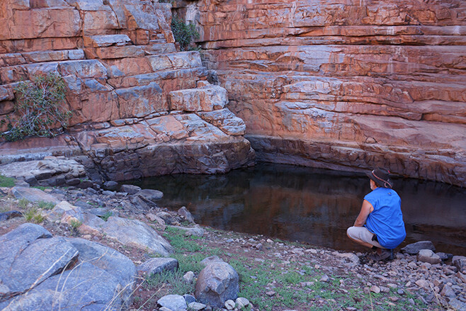
I’ve searched for a number of native water holes and rock holes during our remote desert travels and rarely are they found easily. In Sun and Sand, Terry describes O’Grady’s Well being found at the eastern end of the Sandford Cliffs, and he had approached the cliffs from the east as we were doing. We pulled up close to the cliffs and spread out, our party all keen to find the well. And it was remarkably easy, with my mate and travelling companion, Neil, spying it from a lofty rock he had climbed.
Lying in an almost imperceptible creek bed that ran from a low rocky amphitheatre, the well was located just 50 metres or so from the more dominant rocky cliffs at the south-eastern end of the cliffs. Surrounded by tea-tree, it was much smaller and shallower than when Michael Terry had first seen it, being only about five metres below ground level with no water in it – though I’m sure with a bit of digging, water could be found in there.
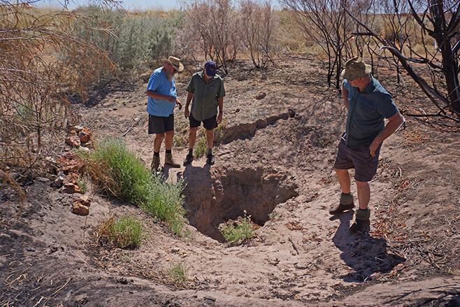
It’s obvious that when rain does fall here a lot of silt gets washed down the creek and fills the well. So in days past, the aboriginal people would have kept busy keeping it clean and accessible to its reported depth of 10 metres or more. Even though it was shallower and not as big as first reported, we were mighty pleased with ourselves.
We spent the next day exploring around the rocky hills and found the odd small cave and overhang, but little else. We saw very little sign of life with no wallabies or kangaroos present, although we learnt from their droppings that they sometimes used the caves and overhangs for shade and protection. We got the impression, though, that these isolated cliffs were rarely used.
The next day saw us heading back east. Once we made the track network we turned south heading toward the outstation of Emu Bore. We took a new mining track we had been told about and given permission to use by one of the traditional owners at Nyirripi. At Emu Bore we picked up another track which headed south and then swung west for a long run down a valley between the east-west dunes.
We arrived at Kalipima Native Well and were side-tracked while trying to find the water point amongst some tall gum trees and coolibahs. Eventually we found the well a few hundred metres south, its dry depression attracting wandering camels by the look of the churned up dust bowls which the large animals used for a dust bath nearby. From here the track swung east to run between the dunes again, before swinging south and eventually coming out on the Gary Junction Road at the Sandy Blight Junction.
Our adventure was nearly over as we turned east for the run back to Alice Springs. Now, having been to two of Michael Terry’s most note-worthy destinations – the other was Chugga Kurri, which I visited in 1990 – I only have one more to go, but the Cleland Hills will have to wait for another day.
Click here to learn more about Michael Terry.
Get the latest info on all things 4X4 Australia by signing up to our newsletter.
The success of a ‘how to crap in Outback Australia’ video on Youtube has inspired an Aussie four-wheel drive nut to redouble his campaign efforts for cleaner campsites.
Sherbrooke Community Radio Club President Jim McNabb’s bush toilet training video – which details exactly what a shovel is, the different parts of it and how to use them – has received more than 22,000 hits in about two weeks.
Its success has encouraged the 66-year-old adventurer to broaden his quest for a cleaner bush, with plans for more educational videos in motion.
In one of Jim’s recent videos – The right way to leave a campsite – he thanks the campers who do the right thing at campsites.
“This is the way,” Jim says. “No rubbish left in the fireplace and no crap behind every bush.”
Time will tell if Jim’s new videos will be as successful as his toilet training video. But at least he’s having a go.
“I’m over the moon,” he says. “I never thought that I would stir up so much.”
Jim has already received a wave of support, with many sharing his concerns about bush litter.
“You’ve made it so easy,” one Youtube fan says. “I really hope the idiots get it.”
Jim is now even entertaining the idea of founding a ‘Clean up our Campsites’ day.
Click here to read about Jim’s how to poo in the bush video.
Get the latest info on all things 4X4 Australia by signing up to our newsletter.
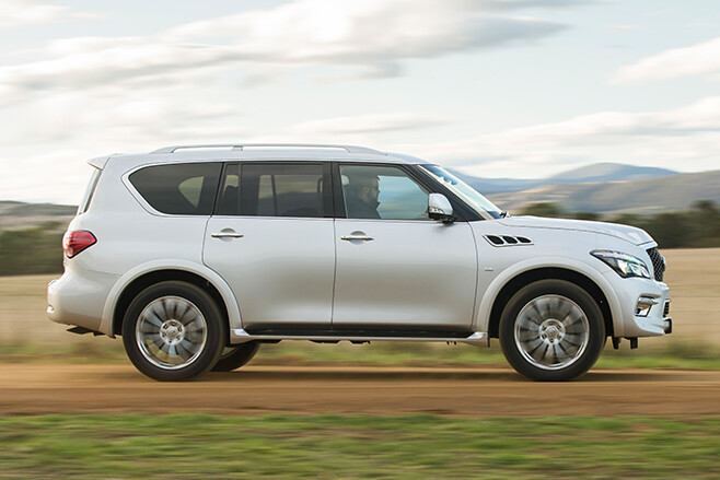
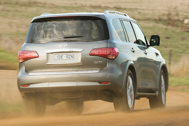
The 2015 Infiniti QX80 comes as part of a fascinating attempt by Renault-Nissan to pick its luxury arm up, dust it off and send it on another run.
Put simply, the QX80 is a Nissan Patrol loaded to the hilt with luxo items and a $110,900 price tag, described by Infiniti as a “hamburger with the lot”.
It’s rolling into the neighbourhood of the Lexus LX570 and it wants soccer mums, small business owners and those who see a three-tonne truck with tinsel as good value.
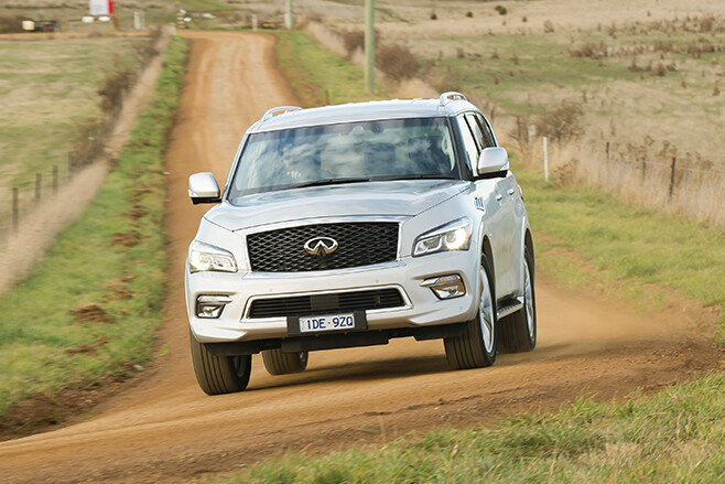
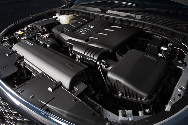
There’s one model, and it comes with the 5.6-litre VK56VD petrol V8 and 7-speed auto that’s been offered in the Patrol since 2013, with identical 298kW and 560Nm torque figures.
What has changed significantly is the outside: in what must be the most notable automotive tribute to the rhinoceros, the QX80 looks like it has a massive growth under its bonnet, fronted by a massive trapezoidal corporate grille and adaptive LEDs.

It’s longer, wider and higher than Patrol, making it super tall and imposing: even the rear windscreen is super upright.
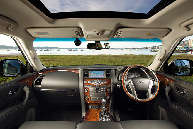
So too the driving position: for such a large truck, there’s not much room for the driver. Headroom, yes, but elbow, knee and legroom is adequate, not spacious.
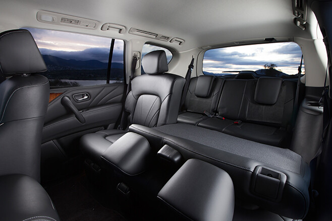
As the “Hamburger with the lot” there’s not only a second row of electrically folding seats − with loads of legroom and headroom − but also a third, compete with cup-holders, to match arch rival Lexus LX570 as an eight seater.
There’s also a heap of gear including a heated steering wheel, rear DVD screens and a four-year warranty instead of the Patrol’s three.
Infiniti says ‘sportiness’ is in its DNA, but there’s nothing sporty about the QX80.
Riding on 22-inch Bridgestone-shod alloys, its ride is jiggley, compromised and delivers an annoying patina over pock-marked surfaces.
It’s better at speed, and handles huge potholes well, even though the hydraulic suspension is around 10% stiffer than in Patrol.
That’s the extent of the mechanical changes over the Nissan off-roader, which is unfortunate because the Y62 Patrol is hardly a dynamic inspiration.
It means that the QX80 is as far from driving pleasure as they come. While the V8 sounds grunty and tough, the throttle is hardly responsive and lacks progression.
A light push sees a delayed rise in revs too late out of a corner, slow kickback reducing its ability to get up and go.
The 2.8-tone mass makes the QX80 feel clumsy, cumbersome and difficult to manage.
It’s upset by mid-corner bumps and has lifeless steering that feels completely disconnected from the vast postcodes of vehicle around you.
With a slow turn in, that steering − which is unchanged from Patrol, by the way − fails to feed back what’s going on.
It’s not until the mass tells you through the body roll as you slide off the inadequately flat (and overly hard) seats that you know it’s time to turn.
A win for the Infiniti over the Nissan is in refinement: there’s more noise-filtering foam in the pillars, and thicker window glass for an impressive quiet cabin.
But does this make it worth $23k more, even if it’s significantly cheaper than the Lexus and rivals with similar power from brands like Mercedes and Range Rover? No. The cabin, with its simple non-texture leather, ’90s woodgrain and ambience is inoffensive yet hardly elegant. It has to woo buyers who have the cash for cars such as the new Audi Q7.
In this class, the Infiniti looks like a nice try, but offers superficial luxury as opposed to genuine depth and craftsmanship.
If a hamburger with the lot is your preference over Wagyu beef, then the QX80 will hit the spot. Yet we think a steak and some left over cash is far, far more convincing.

SPECS
Model: Infiniti QX80 S Premium
Engine: 5552cc V8 (90°), dohc, 32v
Power: 298kW@5800rpm
Torque: 560Nm@4000rpm
Transmission: 7-speed automatic
Weight: 2837kg
0-100km/h: 7.5sec
Fuel Economy: 14.8L/100km
On sale: Now
Want to see the most popular 4X4s of 2015? Check them out here!
You can get the latest info on all things 4X4 Australia by signing up to our newsletter.
Australia’s new-car market has topped half a million vehicles for the first six months of the year, with sales of SUVs leading the way.
Toyota’s Hilux continues as the 4×4 sales leader and if you throw in Hilux 4×2 sales for a combined figure of 18,781 year-to-date sales, only the Toyota Corolla (21,750) and the Mazda 3 (20,427) small cars have outsold Toyota’s perennially popular workhorse in the overall market so far this year.
Looking at the dual-range 4×4 market in more detail, the top ten best sellers (with numbers in brackets representing year-to-date sales) are:
No. 1: Toyota Hilux (13,034)
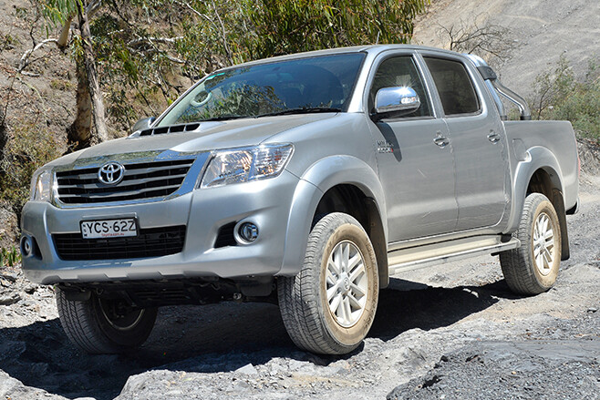
Toyota sold 13,034 Hilux 4x4s in the first half of the year, which is around 700 fewer units than it sold in the same period last year. Nevertheless, this is a great result for what is now effectively a 10-year-old design that’s about to be replaced.
No. 2: Mitsubishi Triton (11,470)
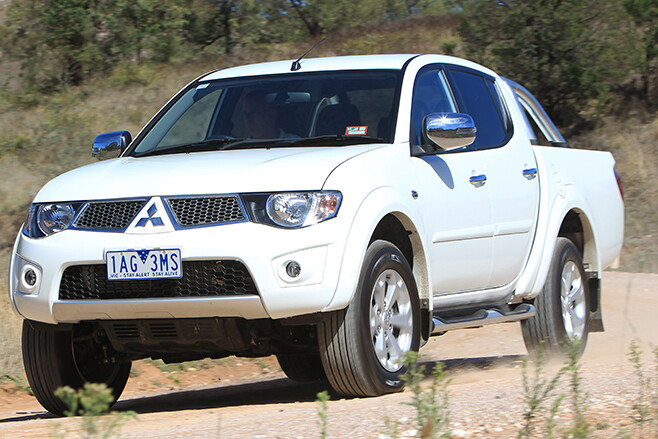
Largely on the back of aggressive pricing of the run-out model, plus the recent introduction of an all-new model, Mitsubishi’s Triton has taken over from the Ford Ranger as Australia’s second most popular 4×4. Year-to-date sales totalled 11,470 units, about 2000 more than total sales in the first half of 2014.
No. 3: Ford Ranger (11,205)
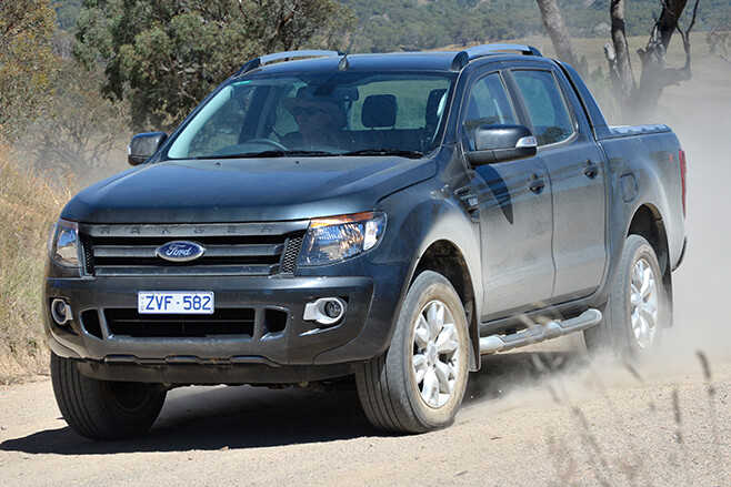
With about 11,205 units sold, Ranger sales increased by 860 units in the first half of 2015 compared to the same time last year, but the vehicle has still dropped one position in the ranking. The current-model Ranger is about four years into its life-cycle and an imminent facelift should give it a boost.
No. 4: Holden Colorado (8304)
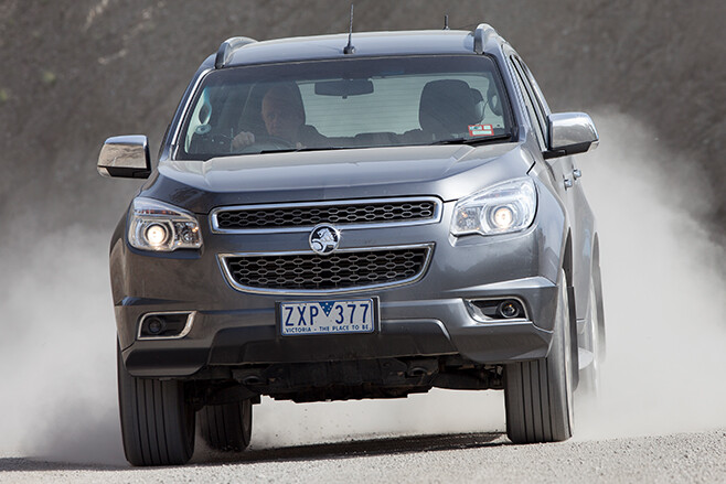
Holden’s Colorado was the sixth-best-selling 4×4 in 2014 and, while it has only sold 300 extra units in the first half of 2015 compared to 2014, it has moved up two places thanks to a decline in popularity of the Jeep Grand Cherokee and Toyota’s Prado.
No. 5: Toyota Prado (7872)
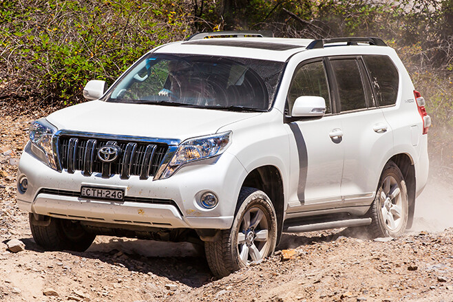
Toyota’s popular mid-sized wagon has reclaimed its spot as Australia’s most popular dual-range 4×4 wagon from the Jeep Grand Cherokee, despite selling about 900 fewer units in the first half of 2015 than in did during the same period in 2014.
No. 6: Jeep Grand Cherokee (6441)
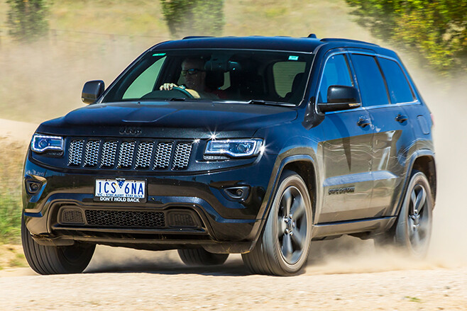
Like the Prado, the Grand Cherokee has dropped in sales in the first half of 2015 compared to its buoyant start to 2014. Jeep sold 2016 fewer Grand Cherokees in the first half of 2015 than it did in 2014, dropping it from Australia’s fourth most popular 4×4 to its sixth most popular.
No. 7: Nissan Navara (6231)
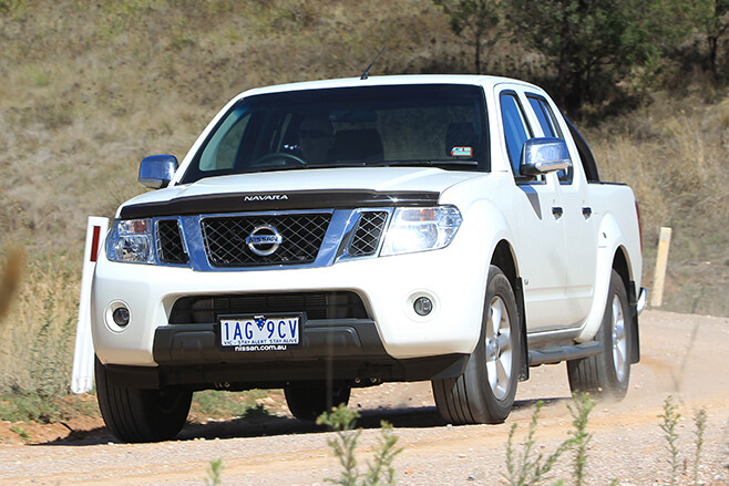
Nissan’s Navara has so far this year held onto its 2014 spot at number seven, despite a decline in popularity. Nissan sold about 1600 fewer Navaras in the first half of 2015 than it did in the same period of 2014. Nissan will no doubt be hoping that the all-new NP300 helps the Navara reclaim its former glory.
No. 8: Isuzu D-Max (5565)
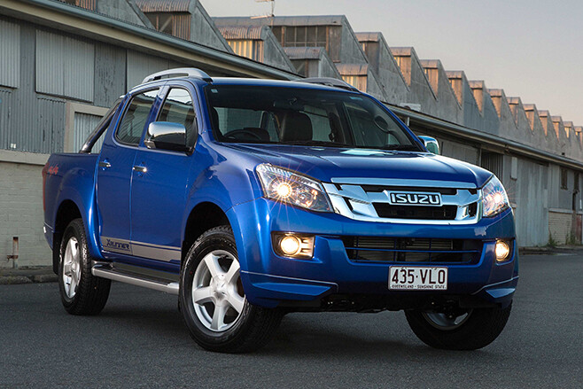
The Isuzu D-Max has continued in 2015 where it left off in 2014 as Australia’s eighth most-popular 4×4. Year-to-date sales were actually up by 677 units compared to the same period last year.
No. 9: Mazda BT-50 (4496)
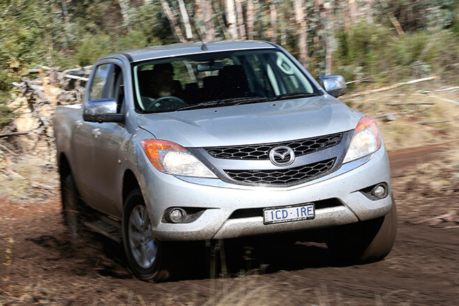
Given the BT-50 is almost mechanically identical to the Ford Ranger, and cheaper, to boot, it should sell better than it does. However, sales are only marginally up year-on-year. It has moved from the number 10 spot in 2014 to number nine in the first half of 2015.
No. 10: Volkswagen Amarok (4457)
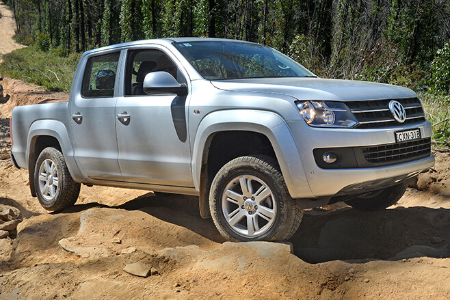
Volkswagen’s Amarok has moved onto the list of top 10 best-selling 4x4s, thanks to both stronger sales in 2015 and a decline in the popularity of Toyota’s 200 Series Land Cruiser. Compared to the same time last year, the Amarok sold about 788 more units.
Meanwhile, the 200 Series has been overtaken by the BT-50, Amarok and Jeep Cherokee to fall to 12th place overall in 4×4 sales, a position that reflects the declining popularity of 4×4 wagons against 4×4 utes.
Battle lines drawn
The battle between 4×4 wagons and 4×4 utes is about to hot up with two new wagons, the Ford Everest and the Toyota Fortuner both slated for release in October. The Everest is based on the Ranger while the Fortuner is Hilux-based. Both retain a live-axle at the rear but have coil rather than leaf springs.
Further boosting wagon stocks will be a new diesel engine in the Prado (due September), a facelifted 200 Series by year’s end and a new generation Mitsubishi Challenger in early 2016. Countering these new and revised wagons will be the all-new Hilux in October and revamps to the Ranger in September and the BT-50 shortly thereafter. Things are certainly going to hot up.
Want to compare to the 2014 Top 4X4 list? Check it out here!
You can get the latest info on all things 4X4 Australia by signing up to our newsletter.
Local legend John ‘Roothy’ Rooth has put the prawn curry aside to join the ranks of 4X4 Australia.
Guess who’s got a new gig?? You beauty – made it at last!Posted by Roothy on Friday, July 17, 2015
Kicking off his four-wheel drive career in 1970, Roothy has finally become a regular in 4X4 Australia, alongside the likes of Ron and Viv Moon, Steve Starling, Dean Mellor and Fraser Stronach, who Roothy says is “one of the fastest guys in Australia”.
“The people who really know their stuff are in 4X4 Australia and despite that, they are letting me in there, too,” he says.
As part of his residency, Roothy will give us bite-sized tales from the bush and his time driving ‘Milo’, the green Toyota Land Cruiser.
They’ll be celebrating out on the mud flats, for sure.
Some words from Roothy:
G’day, fellow four-wheel drivers. My name’s John Rooth. I’ve been around a while. My off-road career kicked off back in the early 1970s when I worked as a bridge carpenter in the bush. Pretty soon I was handling most of the service and repair work because tickets, like workplace health and safety, weren’t things anyone had heard of back then. A bloke had to do the things he was good at, or that nobody else wanted to do.
This was followed by a session at university, then history teaching, before heading bush again to go mining.
For most of the 1980s my brother Nick and I worked the bush, prospecting or paying for it with stints running shearing teams, harvesting, working on the cotton and fixing whatever the cockies had busted last. We even did some time on the roads – possibly a tad more comfortably than the convict side of my family.
Nick and I hit the city in the late 1980s, me to take up a job testing motorcycles for Two Wheels magazine. We both worked in publishing in Sydney before shifting north to Queensland in the 1990s. I’ve spent the last 20 years as a trail bike tour guide and a freelance journo; finding ways to support the family (mostly from a distance).
These days I’m back doing DVDs with my mates from LowRange, track-testing products with Opposite Lock and doing my bit to open up the bush by being the spokesman for Unlock Australia. I’m still playing with trucks and motorbikes every chance I get – as long as they’re pre-1984 and I can understand them.
There’s a variety of trucks in my workshop, including a bunch of old Toyota 40s, a restored WWII Jeep and my product testing rig: a 76 Series Toyota that cranks 200kW. They’ve all got lockers but only the 76 has air-con.
I’ll use these pages to share stories on the tracks and places we visit, the people we meet, and the gear we use on our trips. There’s an endless sea of interesting stuff out there and I’m happy to bring it to the pages of 4X4 Australia.
You can get the latest info on all things 4X4 Australia by signing up to our newsletter.
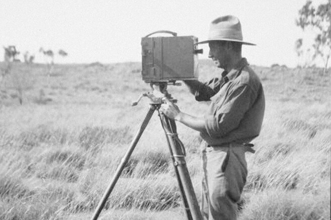
Michael Terry mightn’t be as well-known to four-wheel drivers as Len Beadell, but he pioneered the use of vehicles for exploring remote desert country. Ron tells his story.
When Michael Terry died in Sydney in 1981 his autobiography, The Last Explorer was yet to be finalised. His sister, Charlotte Barnard, compiled the work and it was published in 1987. In 1990, as part of a group led by television host, Glenn Ridge, we travelled to one of Terry’s greatest discoveries and later interviewed Charlotte for the subsequent documentary.
During the course of the filming expedition, we were also lucky enough to interview a great Central Australian character; bush millionaire, long time station owner/manager (including Tempe Downs (1930) and Glen Helen (1940)) and historian, the legendary Bryan Bowman. He had met Terry a number of times, but his opinion of him was diametrically opposed to Charlotte’s.
But I’m getting a little bit ahead of myself.
Terry was born in England in 1899 and as soon as he was 18 and old enough to join the military he enlisted in the Royal Naval Air Service Armoured Cars unit. He served in Russia, was gassed and received a medical discharge at the end of 1918 with a pre-paid ticket to Western Australia.
Arriving in Perth just before he turned 20, Terry got a job as a car delivery driver but soon ended up working on Cardabia Station, on the Coral Coast of the North West Cape, when there wasn’t a tourist to be seen up that way. When that work fell through he bummed his way south and then east on a troop ship to Sydney where he was soon selling cars. After a stint founding and owning a transport company carrying goods in northern NSW, in mid 1922 he headed north to Longreach where he worked in a woolshed before going droving. Soon afterwards he found himself in Winton with, as he said in his biography, “nothing to do”.
Attracted to the vast untracked country to the west he and a mate, Dick, bought a 1913 Model T Ford, overhauled it and in February 1923 set off on an adventure that was to be the first ever crossing of northern Australia by motor vehicle. Working for food and fuel at isolated properties along the way their luck ran out as they approached the WA border.
With no fuel in the Ford, they shouldered their swags and set off to find the nearest homestead. Two days later and near dead from thirst they stumbled onto a small soak that quenched their ravenous needs. After wandering for a couple of days, they realised they were lost and retreated back to the soak where they split up, Dick taking water and the last of the food to make a dash for the homestead somewhere ahead. Dick was later found by some Aboriginal stockmen, and as the police report stated, “In state of collapse. Nearly perished”.
On Dick’s advice a party was dispatched and a patrolling policeman found Terry in a similar state, who was then reunited with his friend. Without any further major mishap they reached Broome on October 4, “giving vent to hearty yells for very joy”.
Back in Sydney, a couple of months later, Terry recounted the story over drinks to a friend. Next day she introduced Terry to the editor of The Sun newspaper … and Terry’s literary career began.
Taking a trip to the USA in 1924 he met Henry Ford seeking some funding for his past adventure and was quickly sent packing. Disenchanted a little he continued to the UK where he lectured to the Royal Geographical Society (RGS), which resulted in him winning a major award from the RGS the following year as well as a grant from the National Geographical Society. That same year he wrote and published Across Unknown Australia.
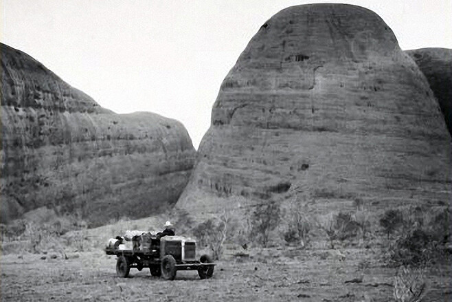
Back in Australia in July 1925 he and a small party of men headed out of Darwin driving two Guy Roadless Vehicles with trailers and riding an AJS motorbike and sidecar.
The British-made Guy vehicles were powered by a four-cylinder petrol engine with inclined valves and an inclined, detachable cylinder head (in two parts) and were known for easy servicing. A four-speed gearbox – with reverse – was standard but down the back the trucks were fitted with factory optioned caterpillar tracks. While those tracks improved traction they were prone to serious wear of the track pins, bushes and seals and were a serious headache for the party.
Another problem was keeping the vehicles cool in the slow tough going, their speed by Terry’s own account not exceeding 20mph and more often, much slower in that the, “machines were coaxed every mile of the way, so as to give them the greatest opportunity of performing in true British style.” They sorted their cooling problems by shipping-in and fitting an extra radiator to each of the trucks at Gordon Downs Station, just west of the WA/NT border.
The five-man party had aimed south-west from Katherine towards Wave Hill and then followed Sturt Creek deep into the desert, past Lake Stretch, and Billiluna Homestead and onto Gregory’s Salt Sea, as Lake Gregory was called then. Then they headed along a completely untracked and little used Canning Stock Route (CSR) to Well 48 and to the now well-visited spots for CSR travellers of the Breaden Hills and Breaden Pool. They were the first people to travel any of the northern section of the stock route with motorised vehicles.
Heading west the short distance to Mt Cornish, they turned back from their goal of Joanna Spring and retraced their steps north to Billiluna. From there they headed on through Ruby Plains HS to the small outpost of Fitzroy Crossing and then followed the Fitzroy River downstream to near Yeeda Homestead, south-east of Derby.
From Yeeda they headed due west, crossing the Fitzroy River before pushing on quickly to Broome and the Indian Ocean, arriving there in late November.
In 1927 the book, Through a Land of Promise, was published, while the movie of the expedition, The Grip of the Wanderlust, shown by private audience to the then Prince of Wales, (later King Edward VIII), has since been lost.
Terry’s third expedition started in Port Hedland in early May 1928, with four men, driving two six-wheel Morris trucks. They headed via De Grey, Pardoo and Wallal homesteads north to Broome, finding and naming a remote spot along the way, about 175km inland from the coast which they called Mt Morris.
From Broome they quickly pushed on to Fitzroy Crossing and then Halls Creek where they searched for gold before heading to the Tanami Goldfields via Flora Valley and Gordon Downs stations. Between Tanami and the Lander River they searched extensively for gold, visiting remote Brooks’ Soak in the process. Fred Brooks had been killed here by Aboriginals just a couple of weeks previously and this led to what was to be called the Conniston Massacres where many, possibly a hundred or more, Aboriginal people were killed in retribution.
Terry and his men didn’t linger and with their gold searching over they pushed on to Alice Springs and then followed the Finke River south to Horseshoe Bend, then Oodnadatta, Hawker, Adelaide and finally, in late December, to Melbourne.
Terry couldn’t enthuse enough about the Morris trucks he’d used and included in his book of the expedition, Hidden Wealth and Hiding People (1931), lots of facts and figures that remain of interest to today’s cross country desert travellers. For instance, fuel consumption of the trucks varied between 5-18mpg while oil consumption was ‘only’ a gallon (4.5 litres) every 250 miles or so. They changed engine oil every 300 to 500 miles, oiled the chassis every 250 to 400 miles and greased the rear suspension every 40 miles when travelling cross country.
Tyre pressure on the 32×6-inch Dunlop tyres was kept at 80psi on the road while through trackless country, 50psi was found to be “the best compromise between maximum adhesion and resistance to stumps”. Even so, the lead truck suffered 41 punctures; many modern-day desert and remote area travellers can relate to all that!
Between 1929 and 1931, in the gloom of the Depression, Terry led a number of expeditions in Central Australia looking for minerals. These included three trips back to the Tanami as well as through the Tomkinson and Blackstone Ranges, the Warburton Ranges and a long traverse north west of Mt Olga to Ernest Giles’s Schwerin Mural Crescent, that majestic sweep of desert ranges just north of todays Great Central Road, east of Warakurna. His book Untold Miles, published in 1932, recounts those adventures in Morris trucks.
In 1932 he led a camel only expedition west from Alice Springs in the company of legendary bushman, Ben Nicker. It was during this trip that he met Bryan Bowman when Bowman owned and was running Tempe Downs.
Bowman, like many central Australian bushies, didn’t have much time for the Englishman and when we interviewed him much later in life, Bowman compared Terry very unfavourably with most bushmen and especially, Ben Nicker. But then again, few people could hold a candle to Nicker when it came to living and surviving in the bush, and Terry himself was glowing in his praise of Ben (for Nicker’s biography read: Bushman of the Red Heart, by Judy Robinson, 1999).
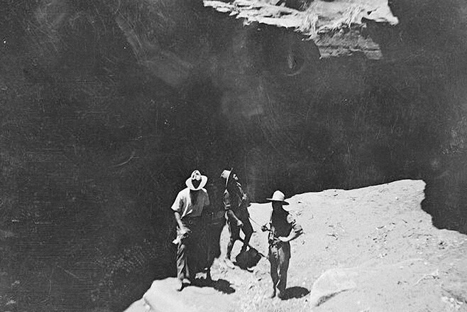
During that 1932 expedition the party covered more than 3000km without meeting another white man, the group unloading their camels for the last time near Laverton, WA. On that trip they discovered a deep and well-worked Aboriginal well that Terry called O’Grady’s Well, just east of the northern end of Lake MacKay. In his book, Sand and Sun (1937) Terry alludes to the theory, that is repeated throughout his writings, that this water point was so well constructed and deep that he believed other beings – from Egypt or beyond – had been instrumental in its construction. In 2014, I visited the remote O’Grady’s Well; it’s a deep Aboriginal watering hole.
The following year Terry and the same small group of men headed out from Alice, again on camels, and rode and walked north west to Vaughan Springs homestead and onto Surprise Well – now full to overflowing from recent widespread rains, unlike the previous year – and then onto O’Grady’s Well. Pushing west they passed around the northern end of Lake MacKay and travelled through the Alec Ross Range before coming to Carnegie’s Bluff and turning north.
Here he was to make, what he considered later in life, his greatest ‘discovery’. Over the years he had heard about a fabled valley, much talked about by Aboriginals over vast areas of Australia. Chugga Kurri was a verdant oasis and in 1933 it lived up to its name when Terry’s party became the first Europeans to visit. Tucked into a great dip in the desert plateau, Terry named the verdant creek he first discovered Brookman Waters and then the depression itself, the Hidden Basin. Later he named Lake Hazlett and Nicker Creek and while he mentioned a number of rockholes and streams trickling water from the cliffs, he never mentioned Labbi Labbi, one of the most permanent water points in the whole region.
Only a couple of other white men have visited this spot, the most notable being the great anthropologist, biologist and photographer, Donald Thomson, in the 1950s and ’60s. Glenn Ridge and I visited this remote basin in 1990. Then, this ‘oasis’ was ravaged by drought and hungry and thirsty camels. Today, each year, possibly one small 4WD group seems to make it to this remote refuge and in 2014 a mate of mine found lakes of fresh water and thick green vegetation out that way, much as when Terry had first seen it.
Terry was in the UK when WWII broke out but quickly found his way back to Australia where numerous attempts to join-up were knocked back because of his health. Commissioned into the Dept of Main Roads he wrote about the history of the Department and the construction of the Stuart Highway in his book Bulldozer (1945).
In 1961, after numerous trips to bolster his freelance writing, Terry set off on yet another mineral quest to the Cleland Hills in the NT. He had been there before and while the area had been found by William Tietkens in 1889 and others had also visited it, it was Terry on this second trip who found the many ancient rock engravings, including stylised faces, that Cleland Hills has become famous for.
These faces had Terry convinced that there had been some foreign contact in the distant past and from then on ‘secret visitors’ became somewhat of an obsession with him and he travelled widely and wrote avidly about it. That work is carried on by others (whether you believe it or not) and can be most easily viewed at: http://secretvisitors.wordpress.com.
In 1974, still sprightly but in too poor a health to do much long distant travelling, he wrote and published War of the Warramullas an insightful and sympathetic account (especially for its day) of his dealings and experiences with the Aboriginals he had met during his many expeditions.
Michael Terry passed away in September 1981 in Sydney, his place in Australian history well recorded, but nearly forgotten these days. Of all the places he named, he named none after himself, saying it wasn’t the way a member of the RGS behaved. Still, in 1957 the Terry Range in WA (south of the Gary Junction Rd and west of Jupiter Well) had been named after him.
In 1988 he and his camel, Dick, featured on the bicentennial commemorative $10 note. While that is as close as the general public got to remembering this great explorer and motor vehicle pioneer, as four-wheel drivers we can visit and revel in many of the places he found and named.
When you do, just remember to touch your hat and pay a silent tribute to this extraordinary explorer.
(Photos from the Michael Terry Collection; National Library of Australia)
Get the latest info on all things 4X4 Australia by signing up to our newsletter.
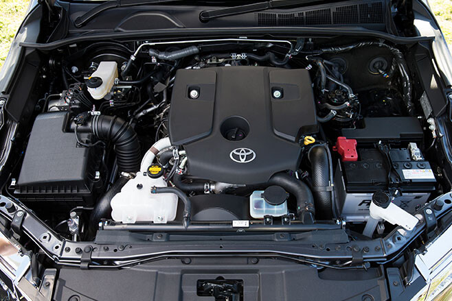
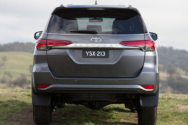
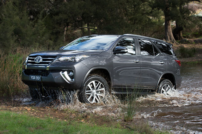
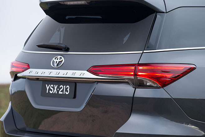
Toyota has revealed its new Fortuner off-roader, which will join the FJ Cruiser, Hilux, Land Cruiser 70-Series and Land Cruiser 200-Series to cement the most comprehensive off-road lineup on the market.
Based on the upcoming new eight-generation Toyota Hilux ute, the Fortuner that goes on sale October 2015 will provide a more affordable seven-seat alternative to the larger Prado and revive the spirit of the once-popular 4Runner sold in the 1980s and ’90s.
Toyota Australia’s executive director sales and marketing Tony Cramb also the Fortuner also provides a “diesel alternative to petrol-only Kluger”.
“It’s equally at home on the school run as it is on the toughest off-road conditions in Australia,” he says.
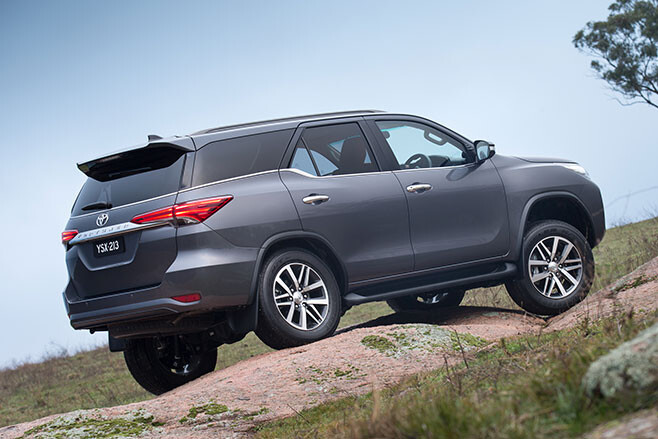
It shares its basic proportions and architecture with the upcoming new Hilux – but with a slightly shorter wheelbase, at 2745mm.
Other items shared between the Hilux and Fortuner include some panels (bonnet and front doors) as well as the windscreen and side windows (minus the small, rear-most window, which is unique).
However, the Fortuner gets a distinctly different look around the nose thanks to a unique bumper, headlights and grille. Combined with black skirting around the wheel arches it visually differentiates the Fortuner from the Hilux with which it shares so much mechanically.

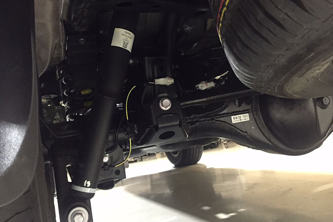
The Fortuner ditches the Hilux’s leaf sprung rear suspension in favour of a coil spring setup designed to improve driving dynamics and comfort, albeit while reducing carrying capacity over the light commercial vehicle it is based on.
The company is also relying on the reputation and image of the Hilux, with Cramb reinforcing it is “incredibly tough” with the “underpinnings of the unbreakable Hilux”.
Toyota blacked out the windows of the sole Fortuner air-freighted to Australia as part of the media launch, but expect it to borrow heavily from the Hilux’s cabin.
The Hilux’s 2.8-litre four-cylinder turbo diesel will be fitted standard; there’s also a 2.4-litre petrol unit available overseas but Toyota Australia decided to stick with a diesel-only lineup. The diesel makes 130kW and 420Nm when mated to the six-speed manual or 450Nm with the six-speed auto.
As with Toyota’s other rugged off-roaders, the Fortuner’s credentials in the bush are strong.The Fortuner gets the Hilux’s dual-range transfer case and part-time four-wheel drive system. There is also a standard mechanical rear diff lock.
There’s also solid underbody protection and 225mm of ground clearance. No word yet on approach and departure angles. It will also get the Active Traction Control system (A-TRC), which along with the suspension and some other components was developed extensively in Australia.
The fuel tank is 80 litres – almost half that of the larger, more expensive Prado – and while fuel use hasn’t been disclosed yet, real-world touring range should be between 500 and 800km, depending on use.
It’s rated to tow 3000kg as a manual – matching key rivals – but only 2800kg with the auto transmission most will opt for.
There will be three models offered – base GX, mid-level GXL and flagship Crusade. GX and GXL will run on 17-inch wheels and tyres while the Crusade steps up to 18s.
All Fortuners will come with a reversing camera, side steps, air-conditioning front and rear and seven airbags; dual front, front-side, a driver’s knee airbag and side curtain airbags covering all three rows.
The Crusade gets roof rails, smart entry/start, powered tailgate, 18-inch wheels and LED high and low beam lights.
There will be a range of locally developed accessories, including two bullbars – one alloy and one steel.
Toyota says it will achieve a five-star ANCAP safety rating.
One thing Toyota is not revealing at the moment is pricing. However Cramb said it would provide a “new entry point for large Toyota diesel SUVs”, suggesting it will be below the entry-level Prado, at $51,990.
So expect the Fortuner to be priced from about $45,000, slotting beneath the Prado, which is itself due for an update in September.
While it will likely trip over the $46,990 FJ Cruiser on pricing, Toyota executives are confident that car’s retro-infused styling and less practical short wheelbase body will ensure it appeals to different buyers.
While it’s conceptually similar to the upcoming Everest (based on the Ranger ute), Ford has positioned its new arrival to compete with the more expensive Prado.
So the Fortuner will compete with more established ute-based off-roaders, such as the Mitsubishi Challenger, Isuzu MU-X and Holden Colorado7.
However, Toyota also believes it will appeal to would-be Kluger buyers who want a diesel engine.
The Fortuner is the seventh SUV in Toyota’s vast range, joining the RAV4, FJ Cruiser, Kluger, Prado, Land Cruiser 70-Series and Land Cruiser 200-Series (although Toyota doesn’t classify the 70-Series as an SUV).
Some executives quietly hoped the Fortuner could revive the more familiar-to-Australians 4Runner nameplate – used between 1984 and 1996 – but it’s understood Toyota’s Japanese headquarters insisted it adopt the global Fortuner nameplate.
“The 4Runner … is only available as a petrol model [in the US] … so we decided to go with Fortuner,” said Cramb.
Toyota Fortuner
Price: From $45,000 (estimated)
Models: GX, GXL, Crusade
Engine: 2.8-litre 4-cylinder turbo diesel
Power: 130kW at 3400rpm
Torque: 420Nm at 1400-2600rpm (manual), 450Nm at 1600-2400rpm (auto)
Transmission: 6-speed manual or 6-speed auto
4WD system: Part-time dual range
Fuel tank: 80 litres
Ground clearance: 225mm
Approach/departure angles: TBA/TBA
Towing capacity: 3000kg (manual), 2800kg (auto)
On sale: October, 2015
You can also get the latest info on all things 4X4 Australia by signing up to our newsletter.
It is official… well, almost. The best 4×4 or all time, according to 4X4 Australia readers, is the tough-as-nails WWII US Army Jeep.
But it wasn’t exactly a landslide victory.
In 4X4 Australia’s online poll, just 17 per cent of readers voted for the army Jeep, while 16.5 per cent voted for the Toyota Land Cruiser 80 Series.
Land Rover came in close at number three, with 14.8 per cent of votes, followed by the Nissan Patrol GQ, with 13.2 per cent of votes.
The Toyota Land Cruiser 70 series was the fifth most popular choice, with 12.6 per cent of votes, while, surprisingly, the Toyota Hilux just missed out on being in the top five – it was voted in at number six, with a semi-respectable 12.1 per cent of votes.
The 1970 Range Rover also performed quite poorly, winning just 1.6 per cent of votes, while the Land Rover Discovery 3 and 4 landed 2.2 per cent of votes.
In the latest edition of 4X4 Australia we rounded up our own expert panel of 4×4 nuts to vote for their top ten 4x4s of all time.
Your Votes:
| 1. WW2 US Army Jeep | 17.% |
| 2. Toyota Land Cruiser 80 Series | 16.5% |
| 3. Land Rover | 14.8% |
| 4. Nissan Patrol GQ | 13.2% |
| 5. Land Cruiser 70 Series | 12.6% |
| 6. Toyota Hilux | 12.1% |
| 7. Toyota Land Cruiser 60 Series | 5.5% |
| 8. Toyota Land Cruiser 40 Series | 4.4% |
| 9. Land Rover Discovery 3 and 4 | 2.2% |
| 10. Range Rover (1970)u00a0 | 1.6% |
The Top 3:
1. The WII Army Jeep
Most commonly known as Willy’s Overland MB (or the godfather, as we like to call it), this Jeep was made tough for tough times. The US Army set strict guidelines regarding the size, weight, engine power and performance of the Jeep – so strict that the vehicle’s initial prototypes were rejected. At the core of the final design were live axles at both ends carried on leaf springs. This allowed the Jeeps to serve as supply vehicles, machine gun mounts, troop carriers and more.
2. Toyota Land Cruiser 80 Series
Strength, durability and all-coil suspension – the 80 Series had a lot going for it, and deserves its spot at number two. Introduced to Australia in 1990, the 80 Series offered full-time 4×4, two new engines, and a giant leap forward in terms of sophistication. However, it still retained the go-anywhere toughness of its predecessors.
3. Land Rover
Created as a stopgap model, this earth roamer helped the planet like no other vehicle. With the spirit of the WWII Army Jeep at its heart, the Land Rover was simple and useful with uncomplicated engineering and barebones comfort levels.