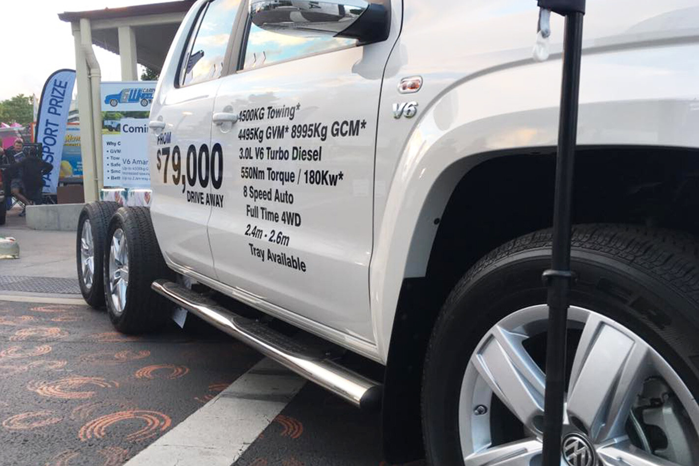
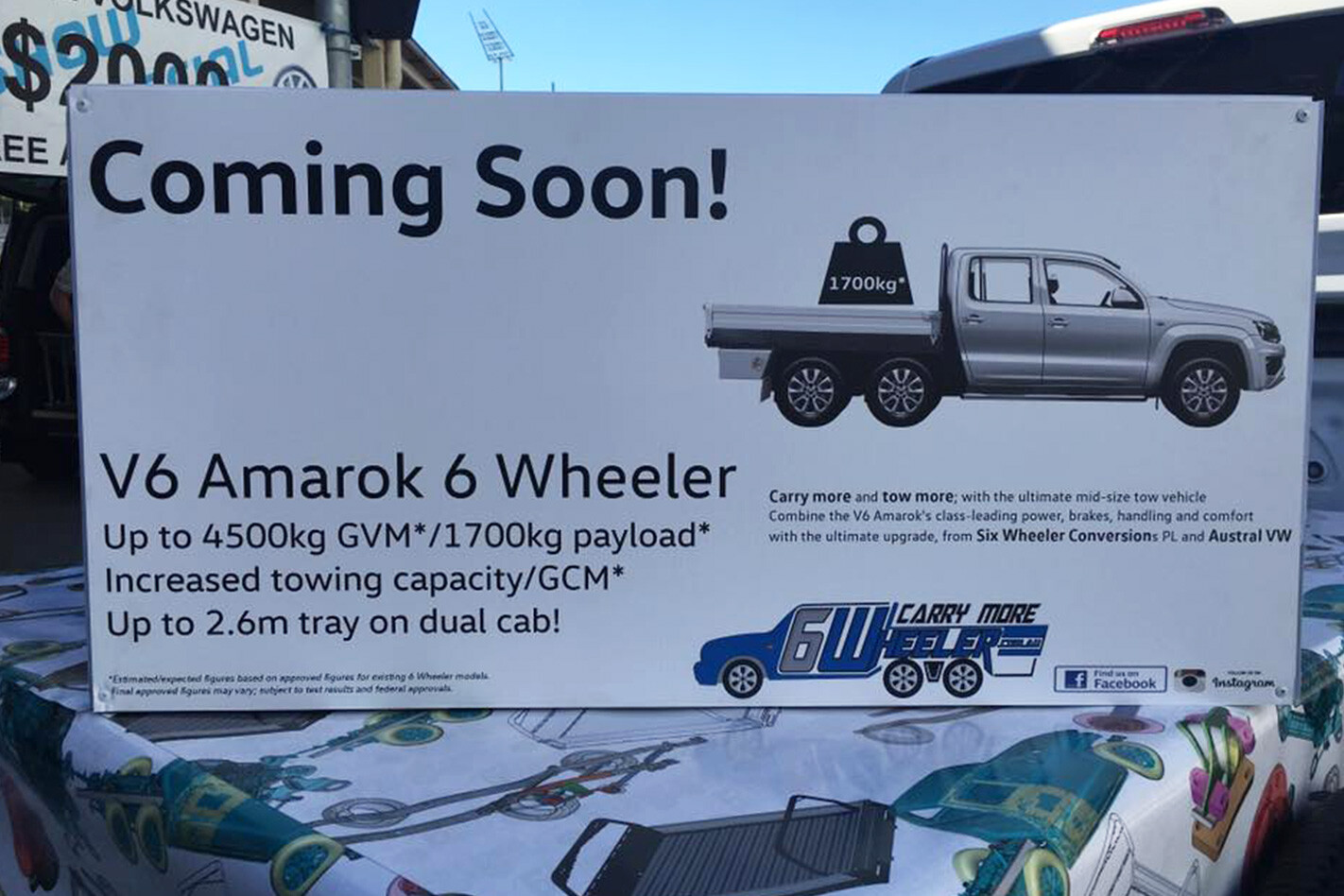
AUSTRAL Volkswagen, a Queensland-based VW dealer, unveiled a prototype 6×4 Amarok at the recent Queensland Caravan Supershow.
The complete revelation is scheduled to take place next month, with the task of the 4×4 to 6×4 conversion in the hands of Six Wheeler Conversions, an Australian conversion company based in Toowoomba, Queensland.
Six Wheel Conversions has more than 30 years of experience converting vehicles to six-wheelers, with its most popular conversions involving Rangers, BT-50s, D-Maxes and LC79s.
Volkswagen Australia confirmed that the conversion is a third party concept with no links to Volkswagen Commercial Vehicles whatsoever.
As can be seen by the signage stamped across the driver’s side door of the 6×4 Amarok, it has a GVM of up to 4500kg, a 1700kg payload capacity, increased towing capacity and GCM (than its four-wheeled stablemate), and a bigger 2.6-metre tray.
The Amarok V6 TDI’s drivetrain, of which the conversion is based on, remains unchanged – that means it gets 165kW, 550Nm and the eight-speed auto. However, expect the conversion to utilise VW’s more powerful 190kW (200kW on overboost), 580Nm 3.0-litre V6 when it arrives in Q3 this year.
The Australian-exclusive 6×4 ’Rok will be priced from $79,000.
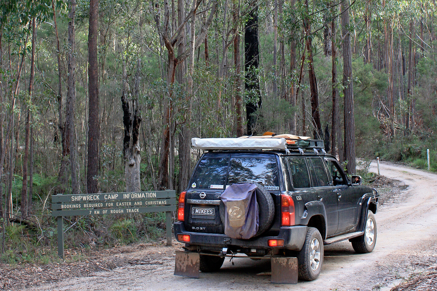
SEASONAL road and track closures in Victoria’s Gippsland’s region will come into effect from June 14.
These temporary forest and park track closures on popular 4×4 routes are administered to ensure driver safety and to prevent track damage during the typically wetter winter and spring months.
“The program helps limit the damage done to forest roads and tracks during the wetter seasons and in doing so ensures dangerous and difficult to negotiate sections of road are closed off from motorists, said Gippsland’s Acting Assistant Chief Fire Officer, Kelly Rash said. “These measures also help maintain water quality in rivers, creeks and reservoirs by reducing the amount of erosion and silt washed away from roads and tracks.”
In the end, it’s a small price to pay to ensure the tracks remain useable for generations to come.
“We encourage the social and recreational use of Victoria’s beautiful natural resources, including four-wheel driving, but some sections of the forest road network would rapidly disintegrate if opened for the entire year,” Rash said. “Together FFMVic and Parks Victoria consult with a range of stakeholders, including Four Wheel Drive Victoria, to identify sections of the road network which require closures.”
Opinion: Victorian High Country is the best 4WD destination in Australia
Most of the tracks are expected to be reopened in time for the Melbourne Cup long weekend, but conditions will dictate closer to the date.
For more information, visit: ffm.vic.gov.au/visiting-state-forests/forest-and-road-closures
If you haven’t been living under a rock, pick-up trucks are fast becoming the choice of many Australians nowadays.
While these workhorses are as tough as they are versatile in their own right, there are areas where a little extra gear could make it even better suited for any particular job or journey you might have in mind for it.
Yakima CrashPad
Mountain biking and utes are a match made in heaven when it comes to transporting two-wheeled rigs to the track. Yakima has a raft of bike-carrying options, but it is the CrashPad that offers the simplest and quickest way to transport multiple MTBs.
Weighing a paltry 1.8kg and measuring 1346mm long by 406mm wide and 51mm thick, the CrashPad is made using high-density foam and tough ballistic nylon construction to ensure your bikes and your ute tailgate are undamaged during transportation of bikes.
The CrashPad fits all common 4×4 utes and is super quick to secure via the strap system – then just load the bikes, secure them to the tray, and away you go.
RRP: $150 Website: www.yakima.com.au
TJM PACE Shock Absorber
TJM has just released the PACE, a dual-adjustable 52mm-bore single-wall monotube shock absorber with remote reservoir. The ‘dual adjustable’ refers to the eight-stage compression and rebound adjustability (accessed via a hand-adjustable dial on the shock and reservoir).
The remote reservoir is connected via a steel-braided oil hose, and there’s a patented internal hydraulic bump-stop inside the shock that assists in dampening the effect of sudden impact on the shock and prevents bottoming-out. It does this by progressively increasing damping resistance as loads increase on the shock. The shock shaft and seals are protected by a stone guard and there’s also an adjustable coilover spring seat (for applicable vehicles).
The Aussie-engineered and designed PACE comes with a three-year/100,000km shocks and struts warranty. Available at launch for LC76, 78 and 79, as well as Ford’s PX Ranger (2012 onwards) and the Mazda BT-50 (2012 onwards).
Website: www.tjm.com.au
ARB Tailgate Assist
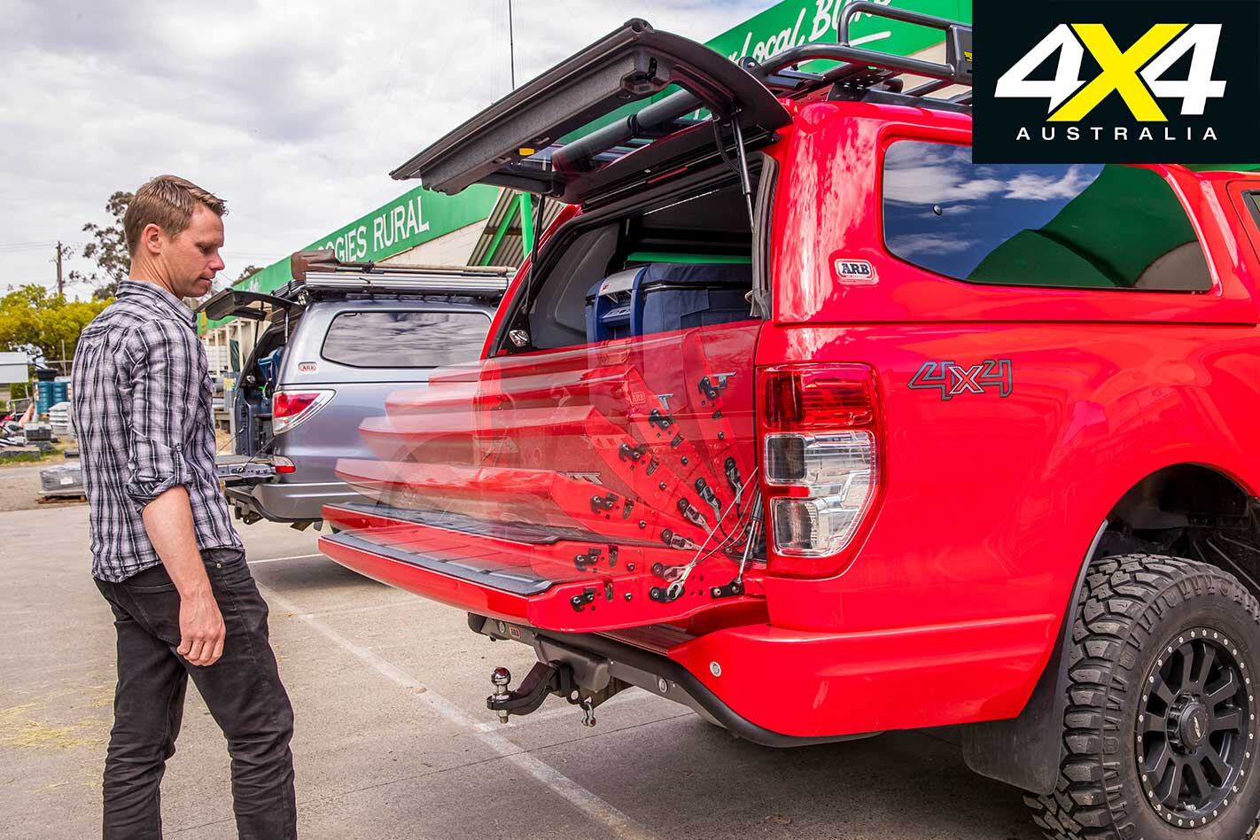
Ute owners know the feeling: hands full of gear, shopping or little ’uns and no way to lower your rig’s tailgate without letting it drop and potentially damage it. ARB’s new Tailgate Assist takes the worry out of that scenario by using two different types of struts to control the lowering of the tailgate.
A damping strut ensures that the tailgate lowers at a controlled rate, while a gas-assisted traction strut works to ensure you can easily close the tailgate with one hand if need be. ARB claims to have reduced the ‘feel’ of the tailgate by up to 50 per cent, making sure it takes minimal effort to open and close.
The kit includes all vehicle-specific hardware and brackets, plus – if needed – ARB replaces the OE cabled or scissor-strap setup. A co-development with strut manufacturer Stabilus, the Tailgate Assist is a great solution to a problem you probably thought would never be solved.
Website: www.arb.com.au
This article was first published in the December 2011 issue of 4×4 Australia.
Light rain caressed my face as I crouched beside the Turon River and scanned the rocky hill ahead for signs of life. Being typical wallaroo habitat, I knew it was only a matter of time before one came to the river to drink.
Barely 15 minutes passed before the muscular black body of a male wallaroo emerged from the bush, followed by its smaller bluish-grey mate. They paused to survey the space for potential danger before moving to the water’s edge. Feral dogs and dingoes have devastated wallaroo populations along the Great Dividing Range over the past decade; it was easy to understand why this pair seemed skittish.
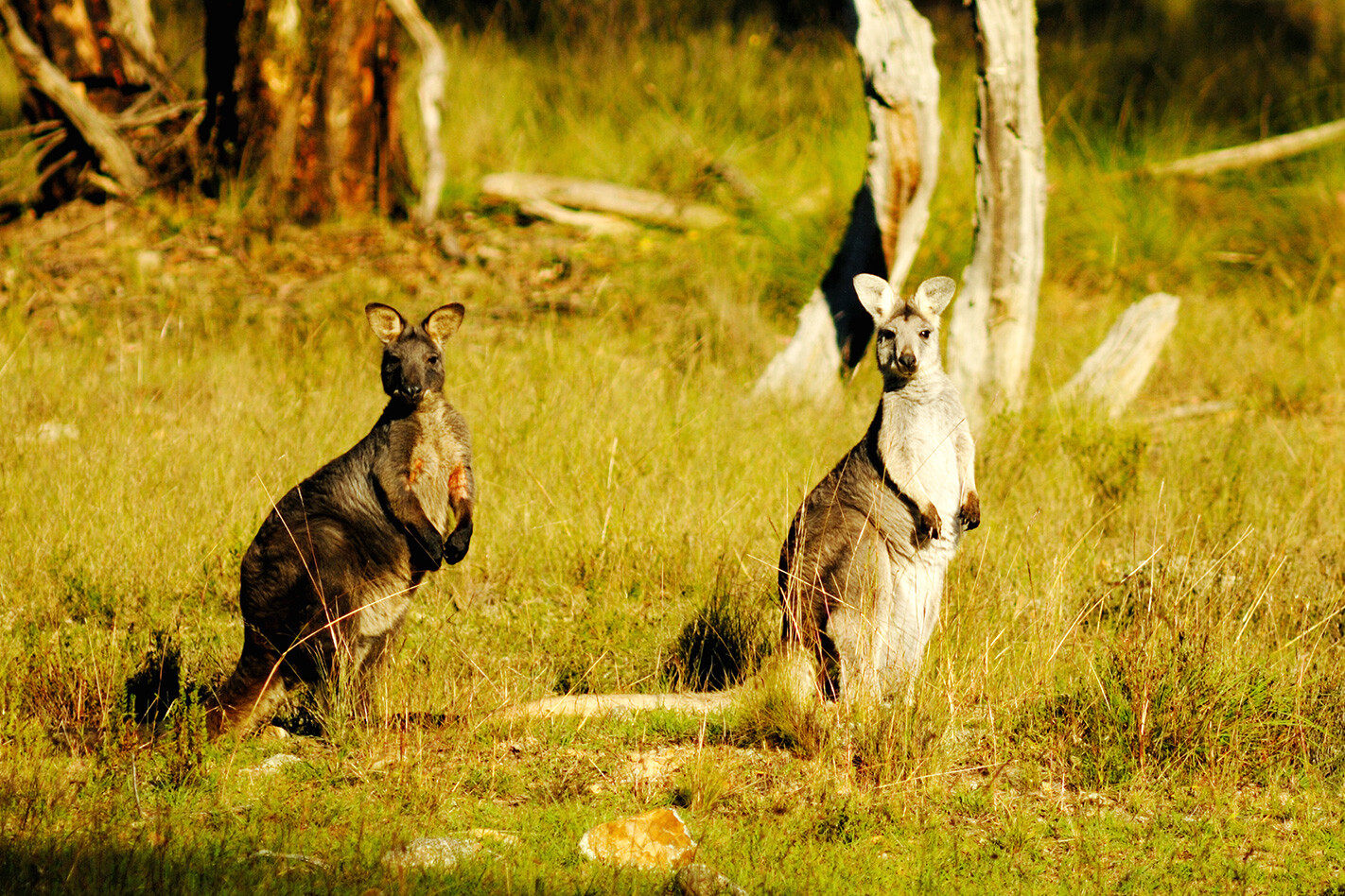
For close encounters with wallaroos, or other native wildlife, it’s hard to go past Turon National Park. Located just 186km north-west of Sydney, near the tiny village of Capertee, it is attracting an increasing number of weekend warriors from Australia’s largest city.
Covering 3060 hectares, Turon NP was established in 2002 to protect the flora and fauna of the western slopes of the Great Dividing Range. The biodiversity of the region has suffered greatly over the past 170 years, largely due to sheep grazing, and many species are now in decline.TURON GOLDFIELDS
Europeans first ventured into the Turon-Capertee region in the 1820s when James Blackman crossed the Blue Mountains and headed north towards present-day Mudgee. He was followed a few years later by wealthy grazier Sir John Jamison, who squatted in the Capertee valley and established a successful cattle station.
Immigrants fleeing the Irish potato famine began arriving in the 1840s and quickly set about clearing the land for sheep so they could cash in on the booming wool markets of Europe.
Tension between new settlers and the Wiradjuri people often resulted in deadly conflicts. These typically arose after Aborigines speared stock to eat, as most of the wildlife they traditionally hunted had been destroyed by the pastoralists.
Even access to traditional watering holes were sometimes sealed off to protect stock, forcing many Wiradjuri to fight for their survival. But spears and boomerangs weren’t a match for 19th-century weapons and, within a decade, the once proud people had been reduced to a few small family groups dotted around the valley.
Ironically, an aboriginal prospector started the gold rush in the Turon-Capertee area when he discovered a 1.36kg gold nugget near the Turon River in 1851. Word of the find spread and miners from all over NSW and Victoria soon descended on Turon in the hope of making their fortune. They were joined by prospectors from as far as the USA and China and, by the mid-1850s, nearly every small stream flowing into the river was abuzz with gold-mining activity.
STRESS LESS
If you are coming from Sydney, stock up on food and fuel in Lithgow, as Capertee (near the park turn-off, 42km to the north) only has a pub and a couple of small shops. Allow time to check out this quaint village, which was once the main centre for the Turon goldfields. Capertee’s first pub was built in 1870 and burnt down 15 years later after a dispute between the publican and a couple of gold miners. Its replacement was built of sandstone and lasted 40 years, until it too was destroyed by fire in the 1930s.
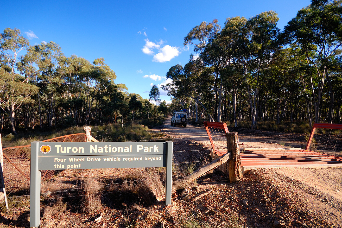
To reach Turon NP, head north from Capertee for about 1km, then turn left onto Lochaber Road and follow the signs for about 2km to the park entrance. From here it’s a further 3km to the camping area. The first kilometre is flat and easy going as you weave through a dense stand of stunted scribbly gums along the top of the range. Many of these gnarled old trees have hollowed-out limbs, making them ideal habitat for possums and gliders. The track then veers sharply left and narrows on the steep descent to the river. There are a number of sharp bends along the way, so beware of oncoming traffic.
Once you reach the track by the river you can turn left towards Woolshed Flat camping area, or right to the more popular camping ground at the Diggings, about 3km away. Both are tranquil spots with toilets, drinking water, picnic tables and a few barbecues and are ideal for family groups. For more secluded camping, there are a number of spots tucked away near the river crossings where you can pitch a tent or roll out a swag for the night.
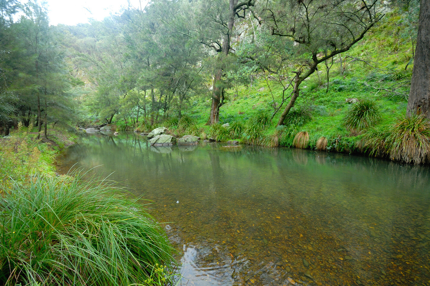
The large she-oaks lining the banks of the Turon River provide plenty of shade on even the hottest days. Birdlife is prolific with numerous species coming down to the water to drink. Crimson rosellas, scarlet honeyeaters, eastern yellow robins and golden whistlers are among the more colourful species seen along the riverbank.
Turon NP is a great spot to recover from modern life. It’s easy to spend hours by the river keeping an eye out for wildlife. With luck, you might even glimpse a platypus breaking the surface – the clear, clean waters of the Turon River are an excellent place to spot the quirky monotreme.
CAMPING
The alluvial flats around the Turon River are littered with remains of old mining shafts, some dating back to the gold rush of the 1850s. While many of the larger ones are blocked off with steel mesh to stop people and wildlife falling in, the numerous smaller shafts are often overgrown with grass or small bushes and can be a danger to the unwary, especially at night.
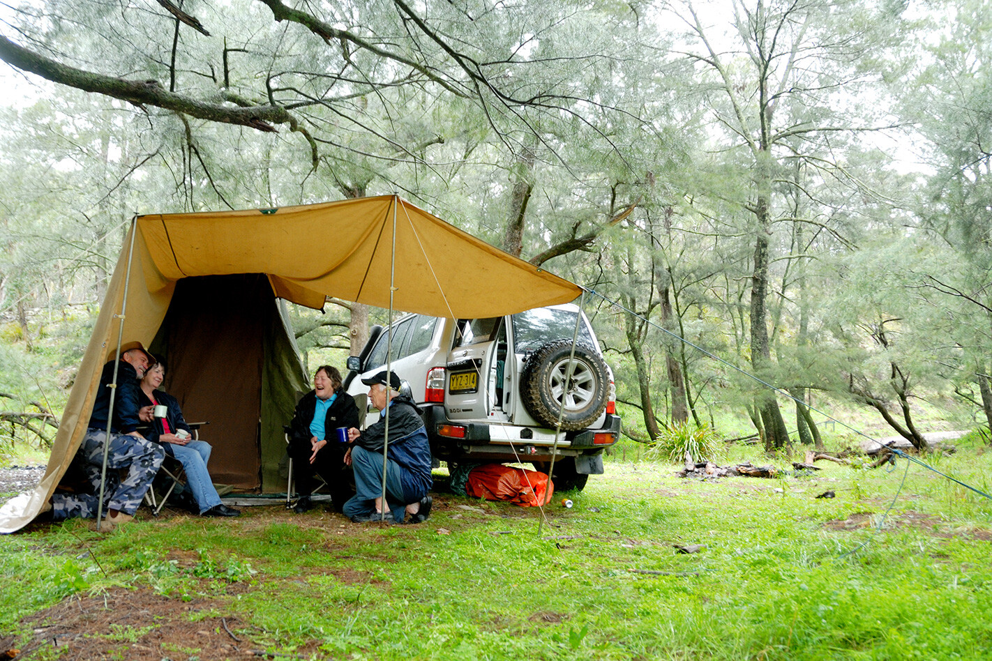
Like many other mountain streams, the Turon River can rise suddenly after heavy rain. Visitors camped close to the riverbank may have to move to higher ground if rain persists. You shouldn’t have to worry too much about rising waters if you stay at the Diggings camping area, as the 20 sites there are fairly safe from fast-rising waters. Set in a large clearing at the junction of the Turon River track and Lochaber Creek track, the Diggings is the more popular of the park’s two camping areas. Bring your own firewood – collecting fallen wood within the park is strictly prohibited, it provides homes for an array of native animals.
EXPLORING
While there are no designated hiking tracks within Turon NP, bushwalkers can easily spend many enjoyable hours meandering along the banks of the Turon River or the small creeks that flow into it.
Wombats are common in this part of NSW, as is the sight of their large burrows. Hikers could try to follow some of the animal trails that follow the steep slopes up from the river. Be sure to carry plenty of drinking water and a compass or a GPS if you try these trails, since it would be easy to become disorientated in this rough, rocky terrain.
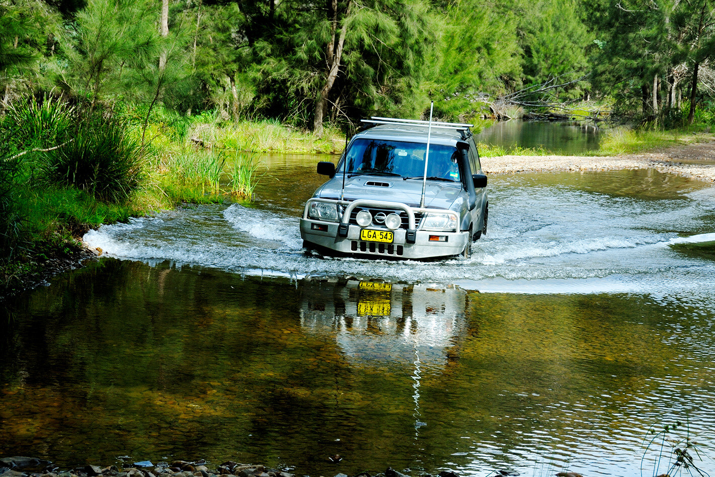
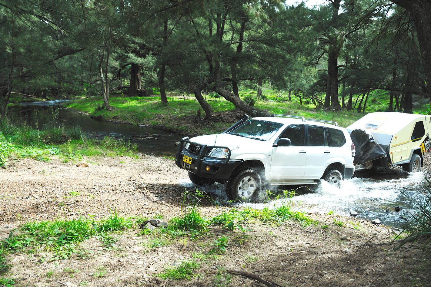
Exploring the park by vehicle is easy, with the main track following the contours of the river for about 12km, making numerous crossings along the way. Most are shallow and the approaches good, so you shouldn’t have any problems if you’re careful. During prolonged rain, avoid the minor tracks that rise up steeply from the river; they can become very slippery and dangerous.

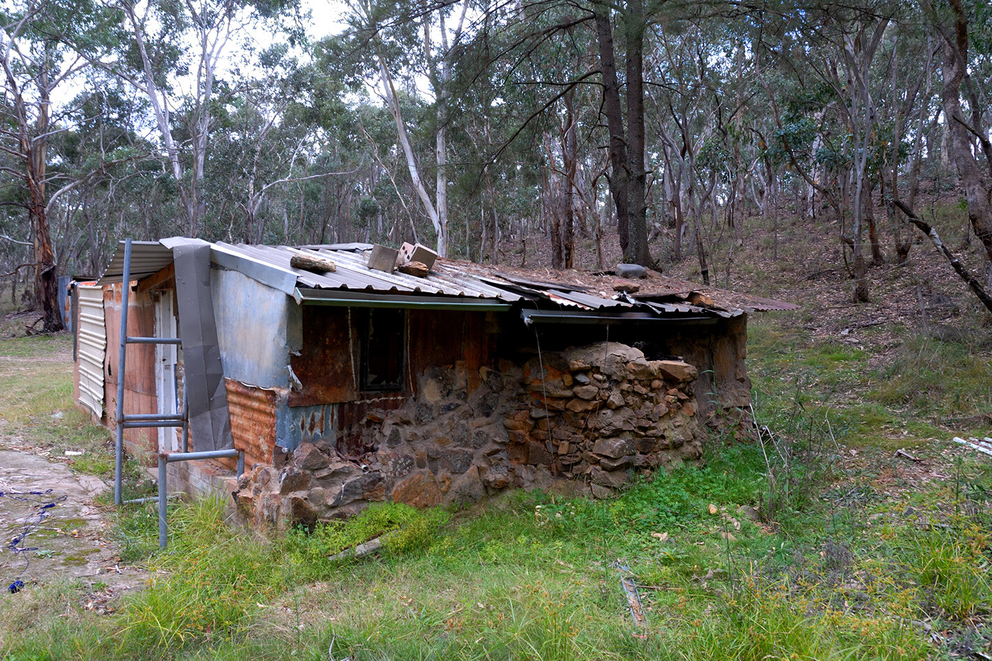
There are a few historical sites to explore as you drive through the park, such as River Ron’s hut. Ron’s hut is made almost entirely of corrugated iron and is typical of the sort of dwelling that prospectors and hermits constructed along the river. Although lacking modern conveniences such as electricity and running water, most of these old huts had a wood stove for cooking and heating in winter, when temperatures can drop below zero.
From River Ron’s hut, the track becomes steep and stony, winding through the hills for about 1.5km until it descends to the large grassy Woolshed Flat camping area. This is a lovely spot and quieter than the more popular Diggings. “It would be hard to find a more tranquil spot to stay anywhere in Australia,” reckons veteran camper Peter Thorpe, who has been coming to the Turon River regularly for the past 20 years. “Not too many people, plenty of wildlife and only a few hours’ drive from Sydney. You couldn’t ask for more.”
TRAVEL PLANNER
WHERE
Turon NP is located about two-and-a-half hours north-west of Sydney, via Lithgow and Capertee.
CAMPING:
There are two camping areas – the Diggings and Woolshed Flat. Both have toilets, barbecues and picnic tables. You can also bush camp at a number of spots along the Turon River. Bring firewood, since collecting it within the park is illegal. Currently there are no charges for camping and no need to book.
WHEN TO GO:
The park can be visited throughout the year. Early mornings in mid-winter can be very cold, with the temperature often falling below zero.
WHAT TO BRING:
Food, drinking water and firewood.
MAPS:
Hema’s Camping Atlas of NSW
This article was originally published in the August 2012 issue of 4×4 Australia.
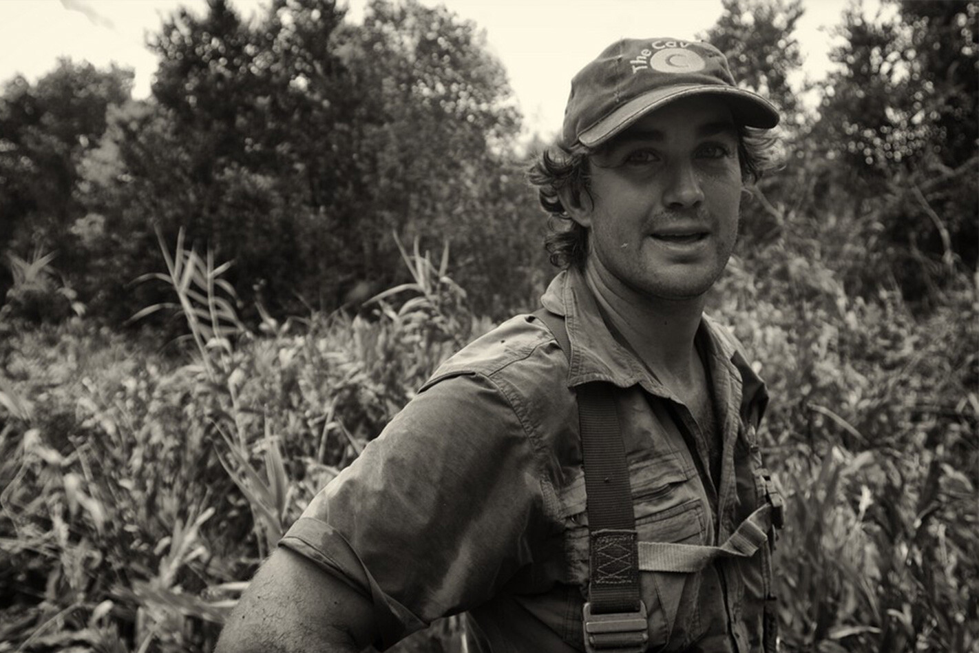
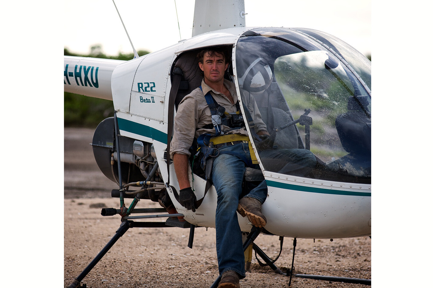
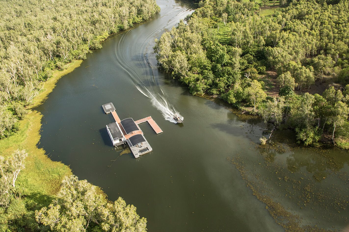
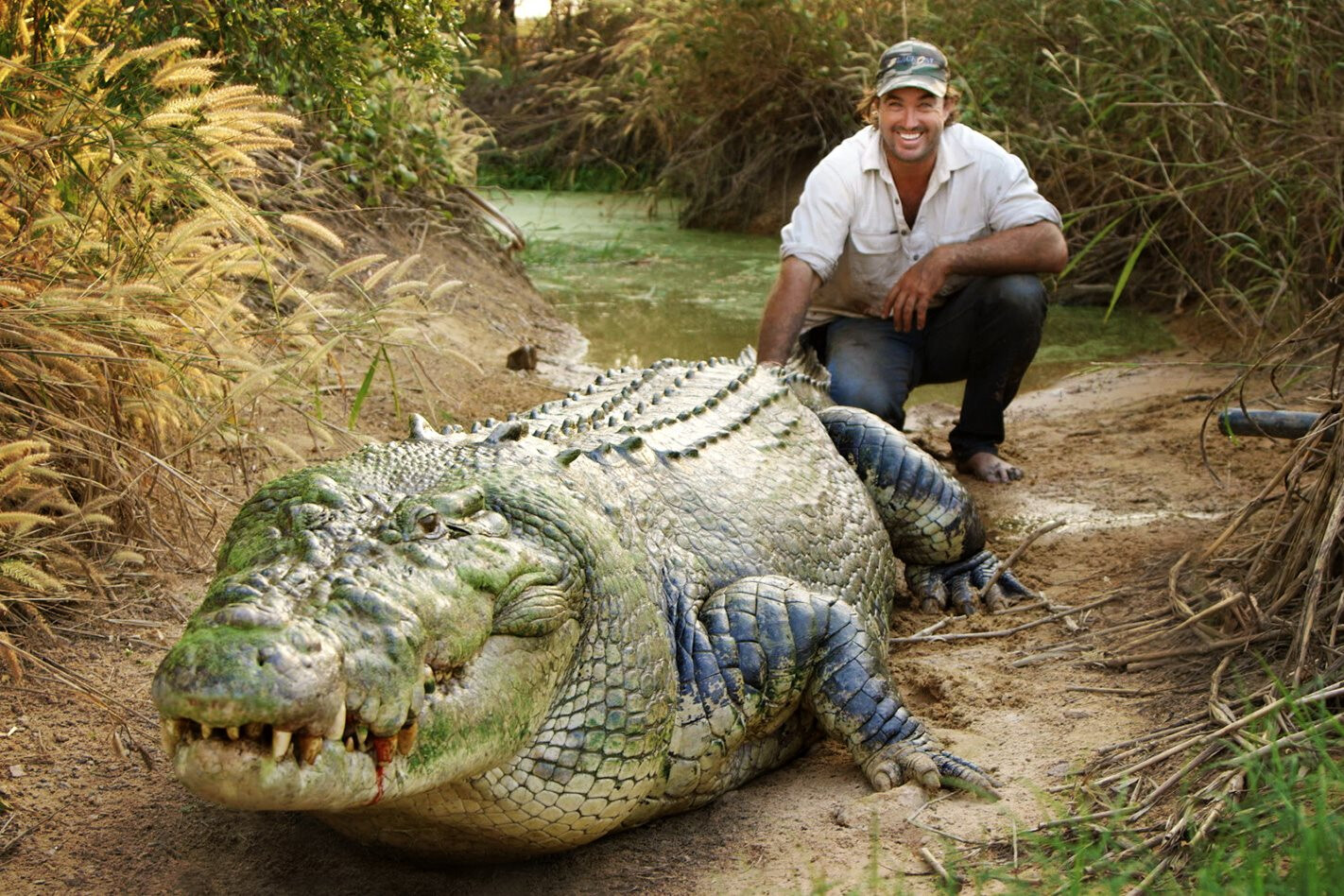
When I caught up with Matt Wright in Sydney recently, the famous adventurer and star of Nat Geo Wild’s Outback Wrangler is just back from a month in the Congo hunting a crocodile that had been eating villagers.
We don’t know how big it is but it took a well-known kayaker, Hendrik Coetzee, and that sparked a bit more interest in why this crocodile’s just coming out of the blue and grabbing people out of boats.
“So I went over there to try and find him. While we didn’t find the one we were after we caught a couple more, but the big fella, no – didn’t even sight him.
“It was the middle of the wet season, high water, tough conditions, so now we’re looking at probably going back in October, September.”
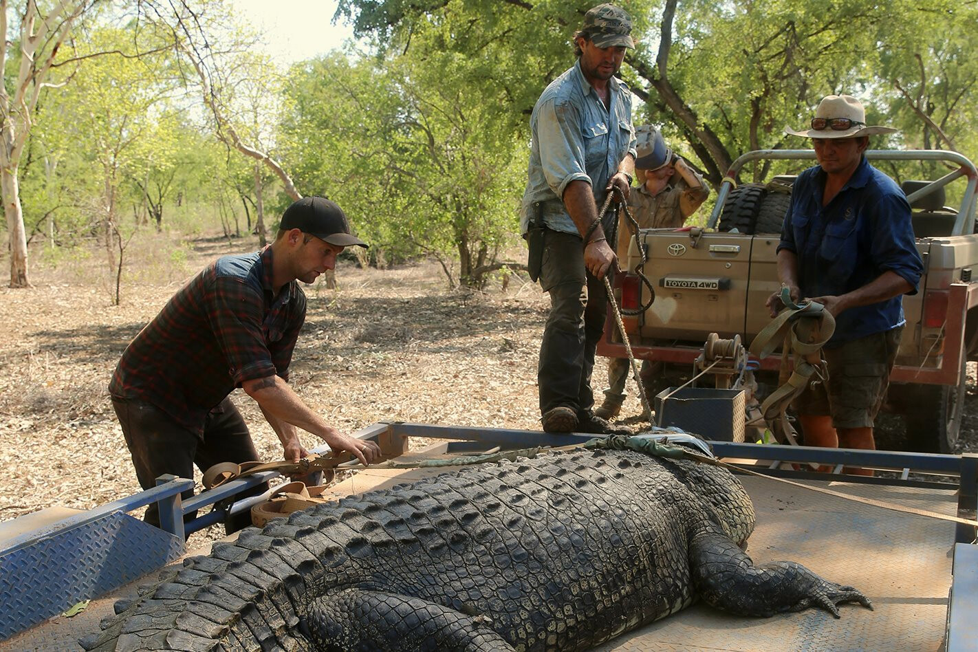
Despite crocodile attacks being much more common in the Congo than in Australia, Matt says there are a lot more crocs in Australia’s Top End.
“The numbers here in Australia are a lot higher, but what we have here are more modern boats that crocodiles can’t come in to, and no-one really goes and washes on the edge of rivers. Occasionally, a fisherman might get taken here or a crocodile might start attacking boats, but we move pretty quickly on it, and we move that crocodile out of that area.”
While crocodile numbers have increased significantly in the Top End over the past few decades, Matt disputes any claims that conservation has lead to there being too many crocs.
“I don’t think crocodile numbers are out of control, they’re just coming back to their normal numbers before they all got shot-out in the 70s.
“Now, when you have a big wet season and there are a lot of floods, crocodiles end up in places they shouldn’t be and they’ve just got to be removed and put back in their waterways. If they end up in someone’s pool, you don’t have to kill ’em, just put ’em back in a waterway, or into a park or [crocodile] farm.”
Despite being a conservationist, Matt says he has no problem with the crocodile farms that breed the animals for use in different products, and prefers this option to shooting crocodiles. “A lot of my work is collecting crocodile eggs, and those eggs go into the parks, they get incubated, they get hatched and three or four years later they get killed. It’s just like a cattle station really; you grow ’em out, you farm them.
“What [these farms] have done now is pretty much conserved the crocodile. We go out and collect the eggs, the station owners are happy because they get royalties for having crocodiles on their properties, so they don’t mind one or two cattle getting taken if they get a cheque at the end of the year for the crocodile eggs there.
“The eggs then go back to the farm, they get hatched out, they get raised and then get sold to an overseas market. Since this has all come into play, crocodile numbers are coming back and coming back quite rapidly.”
“What we don’t want is safari hunting. There’s talk about safari hunting coming in, shooting these crocodiles, but if it’s not regulated right it’s going to be a major problem. They’re going to start shooting all the wild breeding population, whereas going and collecting the eggs, it keeps a balance.”
As well as growing up in Cairns and Papua New Guinea, Matt spent much of his youth in South Australia. “I had a passion for wildlife when I was a kid,” says Matt when asked how he became a man who wrestles crocodiles and other large animals.
“I was always fishing and looking for stuff, hands-on with any sort of wildlife, more so the deadly ones – mum hated it. Then as I got older, about 11 or 12, when I was at mates’ places, on farms and that, the old farmer would want to kill any snakes and I’d say, ‘No, no, I’ll catch it and I’ll move it’.”
Matt’s conservation instinct obviously developed at a very young age and once he’d finished school he headed north from South Oz. “I got in my Toyota and headed up to Alice Springs, Arnhem Land, back to Darwin, back down to Katherine. As I headed through Central Australia, I was working with brumbies and bulls, then further north it was bigger snakes and crocodiles and fish … it just grew with me.
“Then I started flying [choppers], mustering from the air, so it was buffalo and big bulls … and then it was crocodile-egg collecting, and there was no [other] pilot that wanted to do any of that – catch and remove crocodiles. I was 22, just had my licence, green pilot, got thrown into it and I loved it. I wasn’t too worried if I was getting paid or not, I just loved doing it.”
So what are Matt’s favourite parts of Australia? “Broome, Derby, that’s just untouched wilderness, amazing country, and then you fly around the Northern Territory, you’ve got your open flood-plains, masses of crocodiles, hands-on work there, shoot across to Cairns and you’ve got the Great Barrier Reef – if I could have it all in one area it’d be perfect – the Top End of Australia really.
“But I like South Australia and WA, catch up with my mates and go for a surf.
“I spent about a year at Kings Canyon, Ayers Rock, and I loved it. Got all the scorpions, death adders, inland taipans…”
When it comes to his favourite place it really sounds like Matt can’t choose, but when it comes to vehicles he’s a one-make man.
“I started with an old LandCruiser and that stayed with me for six or seven years before it got turned into an old bull-catcher; it’s still out there catching bulls now. I still drive a LandCruiser.
“For what we do, they’re such a hardy car. I’ve had big crocodiles, just load ’em up full of crocs and they just go anywhere once you get them set-up right. It’s pretty much just the outback car the old LandCruiser.”
Having done a lot of outback travel over the years, Matt knows the importance of being prepared for all eventualities. When asked what was the most important lesson he’d learnt from his travelling experiences, he responded with “organisation”.
“Your maintenance on your vehicles – especially when you’re going out in the middle of nowhere, you don’t want to get stuck out there – so you need a good vehicle that isn’t going to break down, and then if you do break down then make sure you have all your rations there. Preparation.”
And when he’s travelling in Australia, Matt is never alone thanks to his dog, Nash, who’s always by his side.
“She’s an American bulldog. She’s on the Sunshine Coast now but she travels everywhere with me, except overseas – she flies in the helicopter, the back of the ute.
“She got bitten on the snout by a crocodile the other day. We were out at night and I had to clean up a few. It was only a little one, she’s in the boat and she gets pretty excited and, anyway, she stuck her nose over the side of the boat and it’s nipped her on the snout.”
Matt Wright really is one of those true outback characters who seem too confined in the city. When I ask him what he thought of being in town, his response is clear.
“I come down [to Sydney] to get a few things sorted out, and it’s good to catch up with a few of my mates who live by the beach. When I go to Manly I’ll go for a surf, but as far as the city goes I don’t venture out much. I’m not a big fan of shopping, I like my space and I like my freedom.”
Catching a big croc while filming a segment for Channel 7’s Sunday Night program was what got Matt noticed, not just in Australia, but around the world.
“We had Discovery, Nat Geo, a whole lot of different networks wanting to do something, but I had to make sure that what we did was not going to destroy my whole reputation in my field of work. I had to stick to my guns and say ‘No, this is how it’s going to come about, otherwise I can’t do it’.
“I wanted to show people everything about the work that I did – relocating, animal transfers – and it became bigger when I started working in Canada and Africa, so it became a pretty big project and we signed on with National Geographic, came up with the concept, agreed on the name and we did Outback Wrangler.
“It’s definitely not a cheap show to make, and it’s very hard to make one-hour shows to keep it interesting where people aren’t going to switch off. So what I’d normally do in a year had to be crammed into a month: ‘Today you need to do this, today you need to do that, catch an elephant, catch a crocodile, catch a cobra, can you do all that?’ Yeah, if I find one, of course [laughs]. But it worked and it went well, so I just think that my field of work, and the different work that I’ve done made the show– that I can work with a variety of animals makes the show.”
Outback Wrangler is a huge success and Matt plans to do more of the same in the near future.
“We’re going to make it bigger and better. Shoot half-hour shows this time [down from one hour], still global, a lot of my work’s in Canada, and back to Africa trans-locating large animals to stop them getting poached… Columbia, we’re looking at trying to work with this organisation to move these hippos… we’ll be catching and tagging a few jaguars… there’s a lot to do.”
Matt Wright is a man on a roll and it obviously looks like there’s no slowing him down just yet.
WE’VE HAD a couple of American overlanders staying with us over the last few weeks and, of course, the conversation doesn’t stray far from where we’ve all been and where we’re heading to next.
Tim and Shannon have been touring Australia for the last 10 months in their well-set-up and maintained old Range Rover; and Rick and Kathy (travelin-tortuga.com) have been touring our country for the past 11 months (they’ve been touring the world for 10 years or so). While both couples were in Tassie at the same time, they never managed to catch up until they met at our place.
The conversation eventually got to where they had both been and what area they had enjoyed the most in Australia. While both couples took different routes – clocking up miles in their respective rigs and loving the many places they visited, the people they met and the experiences they were all exposed to – the region they enjoyed the most was the Victorian High Country.
Sure, they hadn’t seen the entire continent, but they had spent plenty of time in northern or central Australia, with both parties wandering down the west coast of the country. And, unlike us, who may take much of our country for granted, they bring fresh eyes and opinions to what is often a parochial view on what is the best part of the country.
I wasn’t surprised the High Country figured so prominently in their opinions. I remember a young Queensland couple paying us a visit when I was in the Ed’s chair after their 12-month circumnavigation of Australia, where they raved about how great the High Country had been and that it was the absolute highlight of their trip.
After an absence of five years or so, recent travels have reinforced how good the Victorian High Country is as a 4WD destination. Just this year, I’ve spent at least six weeks wandering different areas of the mountains; poking my way down a track for the first time, or finding a camp spot tucked beside a mountain stream I hadn’t visited before. Then there are the great vistas and views you get when atop a mountain, such as the famous Blue Rag trig point, the Billy Goat Bluff Track, or on the not-so-well-known Mt Pinnibar.
Before you claim I must be a biased Victorian, I was born in the NT and lived most of my early life in the back blocks of South Australia’s Flinders Ranges. I’ve also done more than 40 trips to Cape York, 20-odd trips to the Kimberley, and I’ve covered the continent reasonably well. However, the Victorian High Country takes a lot of beating.
If you’ve never been there, now is the time to start planning your trip for when the tracks open again later this year – most will close after the Queen’s Birthday holiday weekend in the middle of June. You’ll be pleasantly surprised by how bloody fantastic it is.
%MCEPASTEBIN%
This article was first published in the August 2011 issue of 4×4 Australia.
INGREDIENTS- Enough to make two medium loaves:
- 1kg strong white bread flour
- 3 tspn dried yeast and 1 tspn honey
- 3 cups warm water (approx)
- 2 tspn salt
- 2 tblspn oil
- Extra flour for kneading
INSTRUCTIONS
- Dissolve the yeast in one cup of the warm water, along with the honey. Mix well.
- Place half of the flour only in a large bowl and add the yeast/water mix. Mix really well to make a thick batter.
- First rise: Cover with some cling wrap (spray the surface against the dough with a little oil – it will help stop the dough sticking) and leave the batter to double in size in a warm place.
- When the batter has risen, add the salt and oil along with the remaining half of the flour. Mix to combine and form a dough – it will be a bit sticky. Turn onto a floured board and knead for just a few minutes, adding extra flour if the dough is too sticky to handle.
- Second rise: Spray the inside of the bowl lightly with some oil and put the dough back into the bowl, cover with cling wrap (oil it again) and leave the dough in a warm place to rise until double in size.
- Third rise: Turn the dough out onto a lightly floured work surface and knead for a few minutes, then divide in two. Place into lightly oiled bread tins and leave to rise and double in size again before baking.
- Preheat your oven to 210°C (410°F). Bake for 30 to 35 minutes, then remove the bread from the tins and return to the oven for another five minutes at 180°C (350°F) to brown the bottom of the bread. Cool on wire racks.
This article was first published in the June 2011 issue of 4×4 Australia.
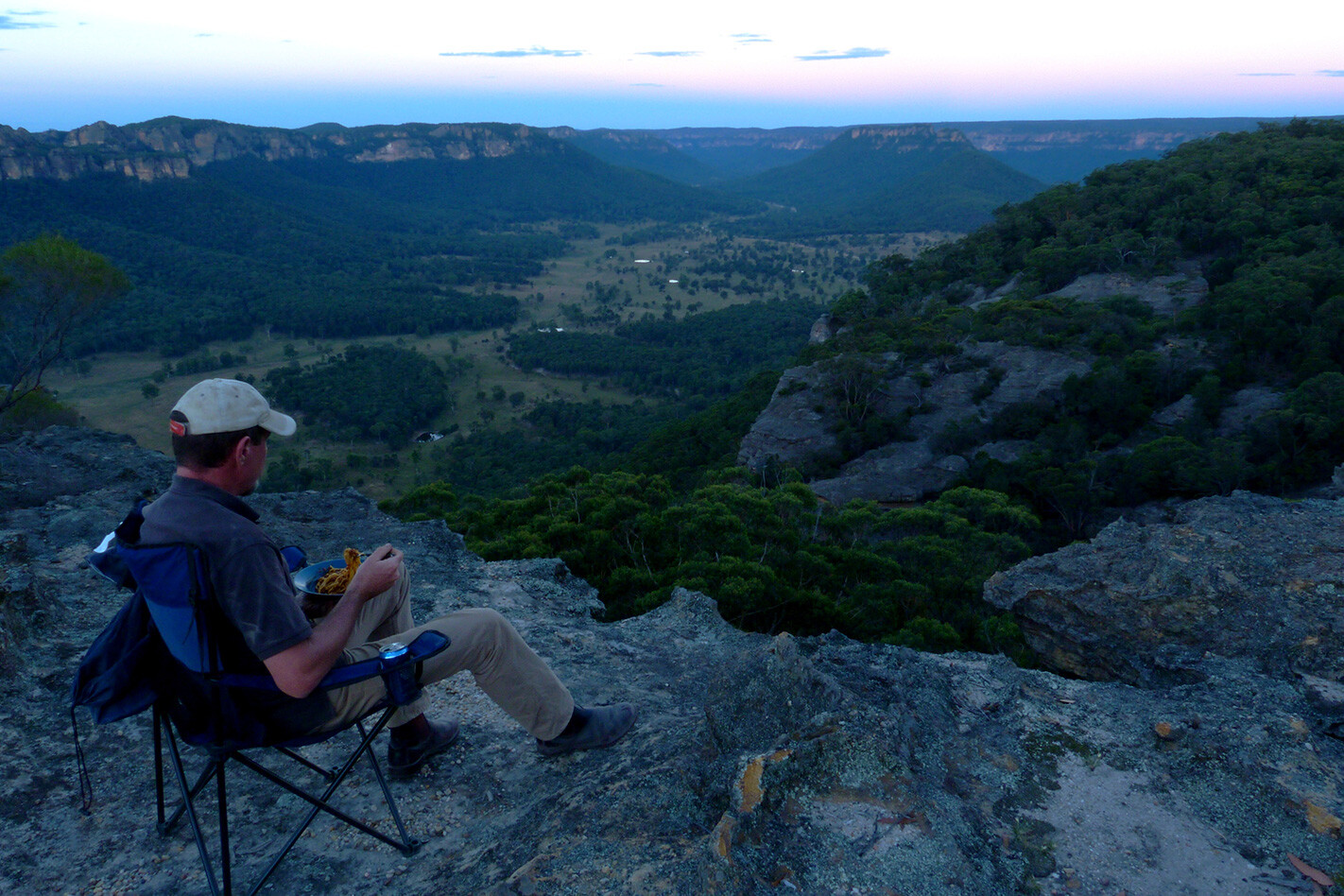
The spag bol wasn’t half bad, but the view was worth five stars.
No wonder I kept coming back here for dinner. It wasn’t a restaurant, just one of the most perfect outdoor settings you’d find anywhere. It was BYO chair, tea, beer, kitchen and bed; the only luxuries on offer being the outlook, the weather and the serenity. All within an easy drive from Sydney.
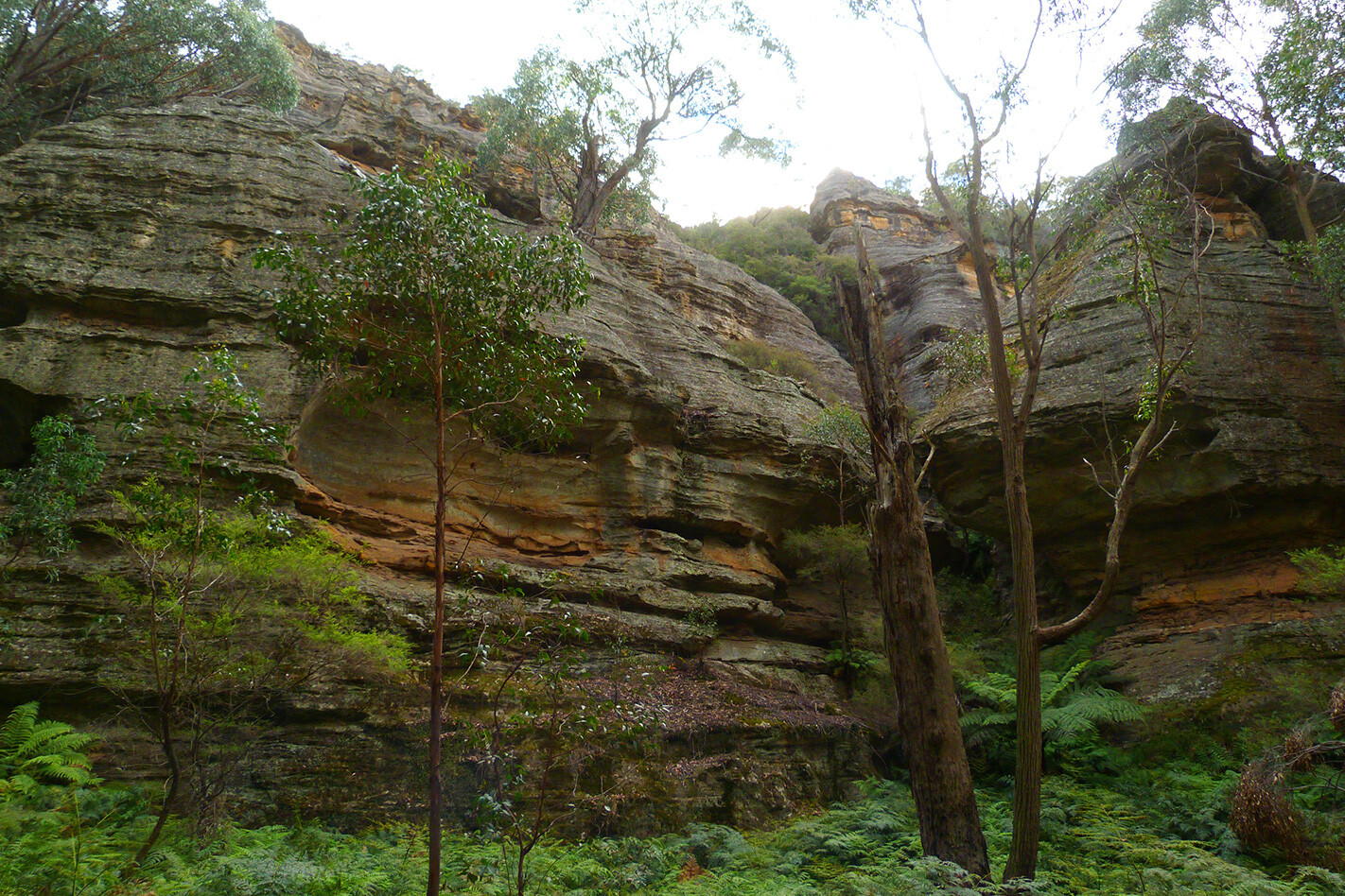
I’d set up camp along the cliff tops overlooking the Wolgan Valley. Donkey Mountain sat centre stage, its skirt of sandstone glowing in the setting sun. Somewhere on the other side was the Glow Worm Tunnel. Black dots that were cattle moved on the farmland 500 metres below. It was beautiful, yet I was so close to the city.
The forests, tracks, historic sites and rugged geography north of Lithgow, NSW, make an ideal overnight escape from Sydney’s rat-race, and you can do some of it in a single day if time’s tight.
Begin at either the Zig Zag Railway, a historic bit of track by Bells Line of Road with old trains you can ride, or in Lithgow, by going out past the State Gully Mine, which is sometimes open for visitors to explore (a few artists still use the forges in the workshop, too). Either way, the roads converge and head north past Bungleboori picnic grounds, where trail bikers congregate on weekends.
Take a right there and the road leads you to the Glow Worm Tunnel, a disused rail tunnel you can walk through – but try not to disturb the fragile little worms which dot the otherwise pitch-black walls. This road’s a dead end, so you backtrack to the picnic area and then drive west along Blackfellows Hand Rd. Don’t veer right on Sunnyside Ridge Rd, another dead end, although there is a nice view out there if you do.
Blackfellows Hand Rd descends into a magical canyon. You can turn right into it and park there, then wander up between the rock walls. Even on hot days, it’s often cool and fresh down there. This track ends when you hit Wolgan Rd’s tarmac. Newnes is up this road to the north, its remnants a reminder of the days of shale-oil mining a hundred-odd years ago. You can spend the night camped up there in pretty surrounds.
But if you dog-leg about 20m north across Wolgan Rd and head up the dirt track into the bush (it’s been moved recently, so maps and GPS units try to send you a little further south), you’ll climb up the Great Dividing Range in Ben Bullen State Forest. Earlier, you’ll have seen the towers of sandstone that give Gardens of Stone National Park its name, but now they are more common and pronounced.
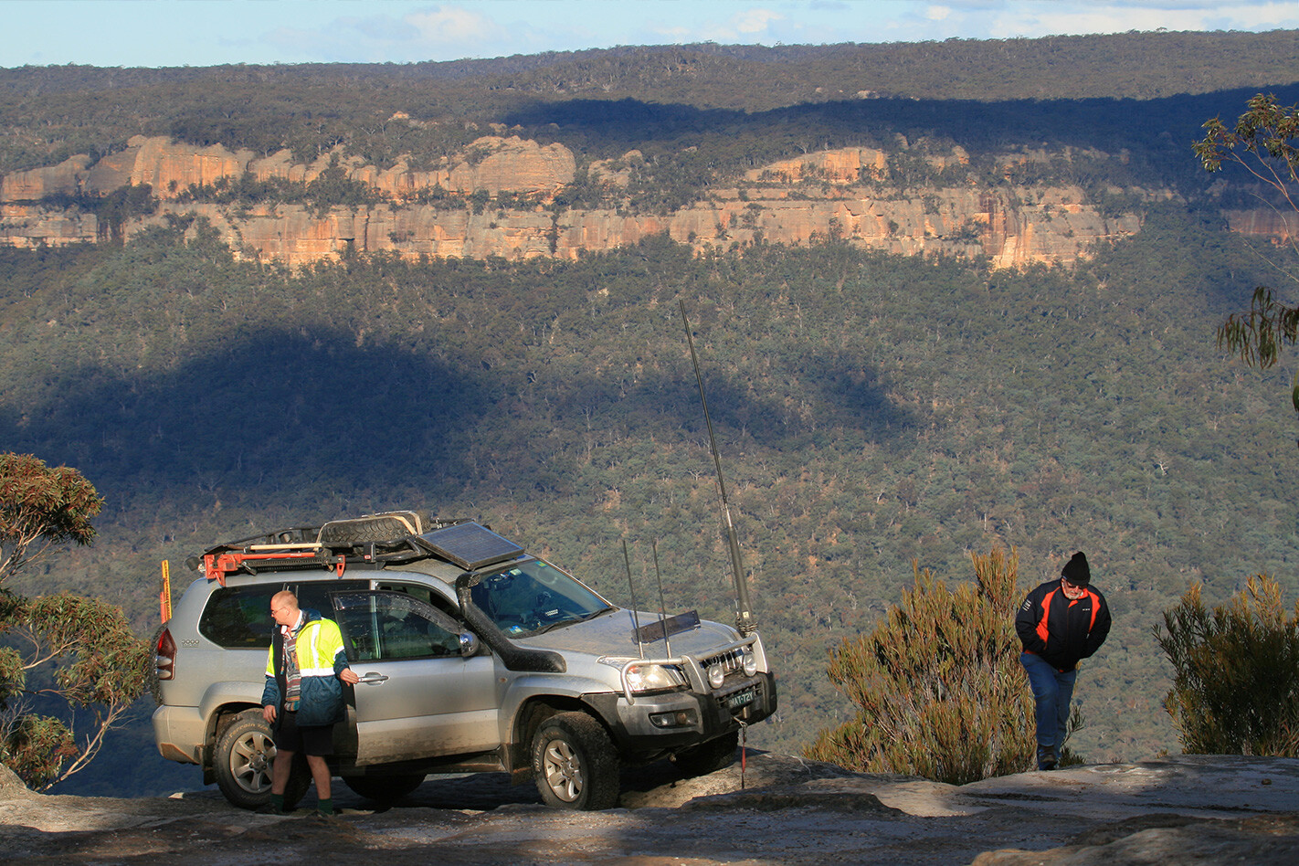
A few kays up this track, the bush suddenly opens up onto a rock platform and the cliffs overlooking Wolgan Valley. It’s worth a stop and a photo – one of the few places you can snap your fourby at an outlook without fences and barriers to spoil the happy snap.
I camped further along here, after taking an unmarked right turn that leads to a high sandstone spit (33°14.897S, 150°07.073E). It’s nice on a still evening but exposed and, at 1000m high, cold if the weather’s wrong. Then it might be best to head on to Baal Bone campground, down in a valley beside a picturesque swamp.
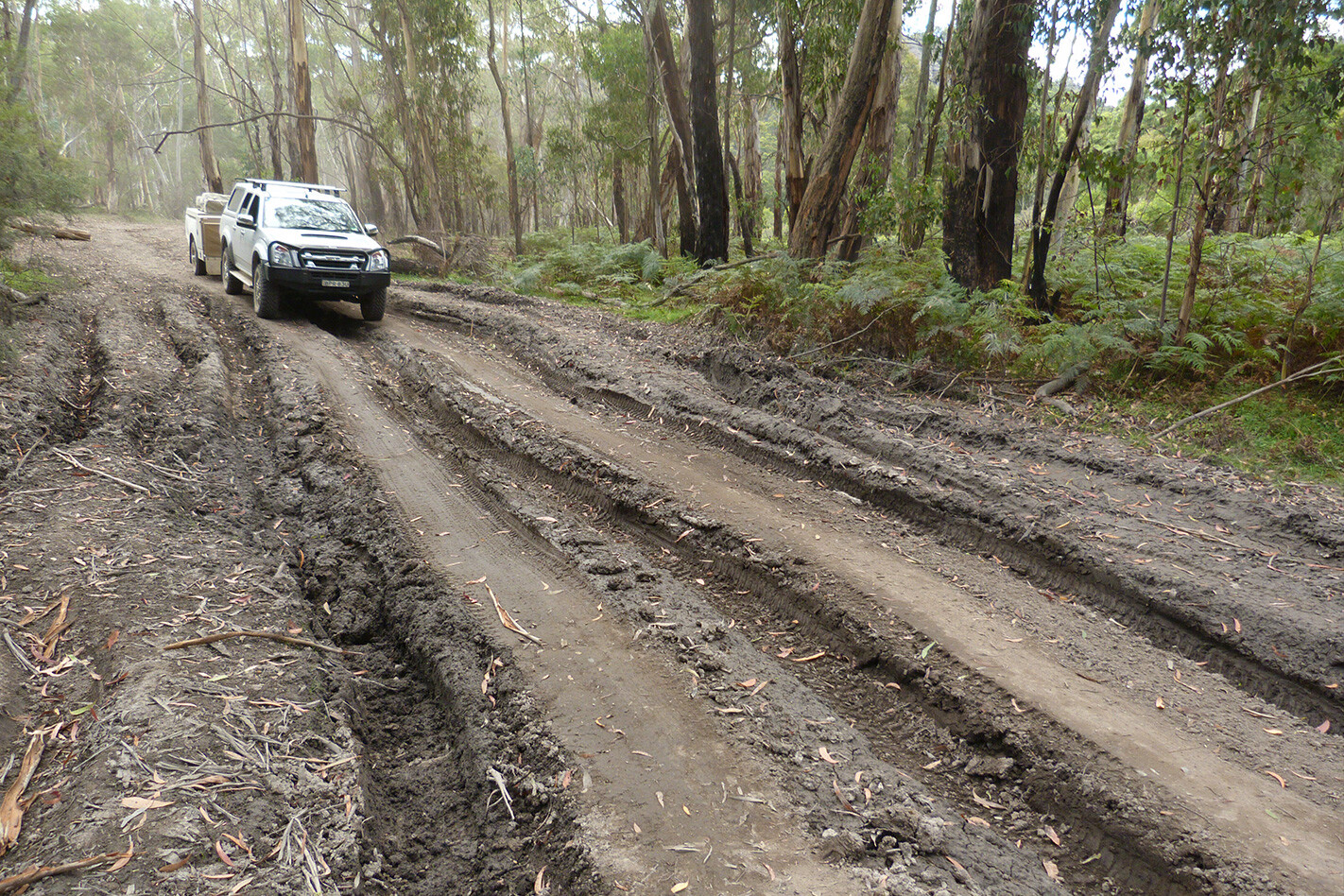
There’s a steep drop into a beautiful canyon on the way, where you’ll want to pick your line. And if you’re coming from the other end, the climb may be a challenge unless the track’s been repaired recently.
Without diff locks, and towing a camper trailer, I barely made it, and then only after a lot of struggle, thought and planning.
Just up from the camping area, the road has been closed at Baal Bone Gap and now forms a bushwalk along Crowns Creek, past Pantoney’s Crown and towards Glen Davis. To continue the drive, go north-west along Moffitt Trail. You’ll finally reach Gardens of Stone NP proper, although you’ll have seen many spectacular and interesting rock formations already.
The driving ends at the Castlereagh Hwy at Ben Bullen. Turn left and you’ll be back in Lithgow in 20 minutes or so, feeling like you’ve been a thousand miles from the big smoke.
Travel planner
GETTING THERE
From Sydney, turn off Bells Line of Road at the Zig Zag Railway, cross the lines and you’re away. From Lithgow, find State Gully Mine Rd and head into the hills. From the north, enter along Hutchinsons Rd where the Castlereagh Hwy crosses the railway at Ben Bullen. Wolgan Rd, from Lidsdale to Newnes, bisects our trip.
WHEN TO VISIT
All year, but of course walking isn’t much fun in mid-summer, and it’s below zero overnight in winter.
ROAD CONDITIONS
Mostly good tracks with some rough sections, but there are a few short, sometimes difficult climbs which require low-range. Some parts get boggy after rain. Mine subsidence in the area can make some bogholes interesting.
FACILITIES
No-frills camping at Baal Bone Campground. Camping, fireplaces, toilets and tables at Bungleboori picnic area in Newnes State Forest. Picnic tables at the Glow Worm Tunnel. Expansive camping area, toilets and fireplaces at Newnes.
SUPPLIES
Lithgow has everything, Lidsdale has a servo with basic supplies, and Newnes and Ben Bullen have nothing.
CONTACTS
Lithgow visitors information centre, 1300 760 276 or 02 6350 3230. National parks info: http://www.nationalparks.nsw.gov.au/visit-a-park/parks/gardens-of-stone-national-park
MAPS Hema’s NSW 4WD Top 50 Atlas & Guide specifically covers part of this trip in words and, in maps, all of it.
WHISPBAR has a wide range of roof bars for vehicles, as well as bike-carrying systems (and watercraft systems) to suit.
The WB201 is Whispbar’s roof-mount bike carrier for those who don’t want to remove their bike’s wheels. It promises users the capability to hold most bike shapes/sizes – 26, 27.5, 29er, roadies, etc. – up to a weight of 20kg (so heavy downhill rigs are out) to the roof bars securely, and with zero impact on the bike’s more fragile components.
Fitting or removing the WB201 is very easy, especially when fitted to a compatible set of Whispbar’s Through Bar roof bars. This ease of operation is due to Whispbar’s “QuickDock” technology. The QuickDock clamp is a swivel-based system comprising two long arms underneath the bike carrier that have a metal tab that slides into the T-slot in the roof bars; it’s then swiveled closed to ensure secure attachment to the bars. The unit is quite light (5.1kg), so fitment and removal is a doddle for any adult.
Fitting a bike to the rack is a simple process of lifting it up, aligning the wheels in the (fully adjustable via sliding) wheel/tyre holders, then lifting up the centre lever so you can move the ‘SmartHold’ frame clamp to the desired position on the bike’s downtube. You then simply push the centre lever back down and, as it closes and locks, it applies the exact amount of pressure the clamp needs to enclose the bike’s downtube securely (rather than having to dial in the pressure via a hand dial as per some other bike carrier setups).
Then you can lock the centre lever and use the ratchet straps to secure the front and rear wheels, thus securing both the bike and the bike rack to the roof of your vehicle. This means no more lock cables threading around your bike’s frame and components. It is a clean-looking setup that works brilliantly.
This bike carrier has seen regular duty on a couple of our motor vehicles in the three years I have owned it; it is testament to the design of the carrier that it hasn’t been changed at all over that period of time – get it right once, I guess, and job’s done. The first few times I used the WB201 there were the obligatory nervous glances either through the vehicle’s sunroof or over at the shadow beside the road to check there was a bike still on top. Since those initial trips I worry no longer – the bike is always there, still attached, at the end of my journey.
The WB201 is very easy (and quick) to remove from the roof bars – thanks to the QuickDock system – and this has been great as I have moved from different vehicles. Nowadays, with my Discovery 2, I am running a spare-wheel mounted bike carrier but have kept the WB201.
Once I get roof rails fitted to the Disco, I will look to purchase some of Whispbar’s low-profile roof racks and re-install the WB201; I am happy with the Yakima SpareRide carrier on there (ironically, Yakima owns Whispbar), but the Disco’s offset spare wheel means the bike is pushed over to the side of oncoming traffic a bit too far for my liking. So the WB201 may be doing plenty of bike-carrying service for a few years yet.
IN AN Australian first, Boulia, a remote outback town in western Queensland, has installed a 3D zebra crossing.
The optical illusion was painted in an attempt to slow down motorists – hopefully by not slamming on the brakes – but also to pique the interest of tourists.
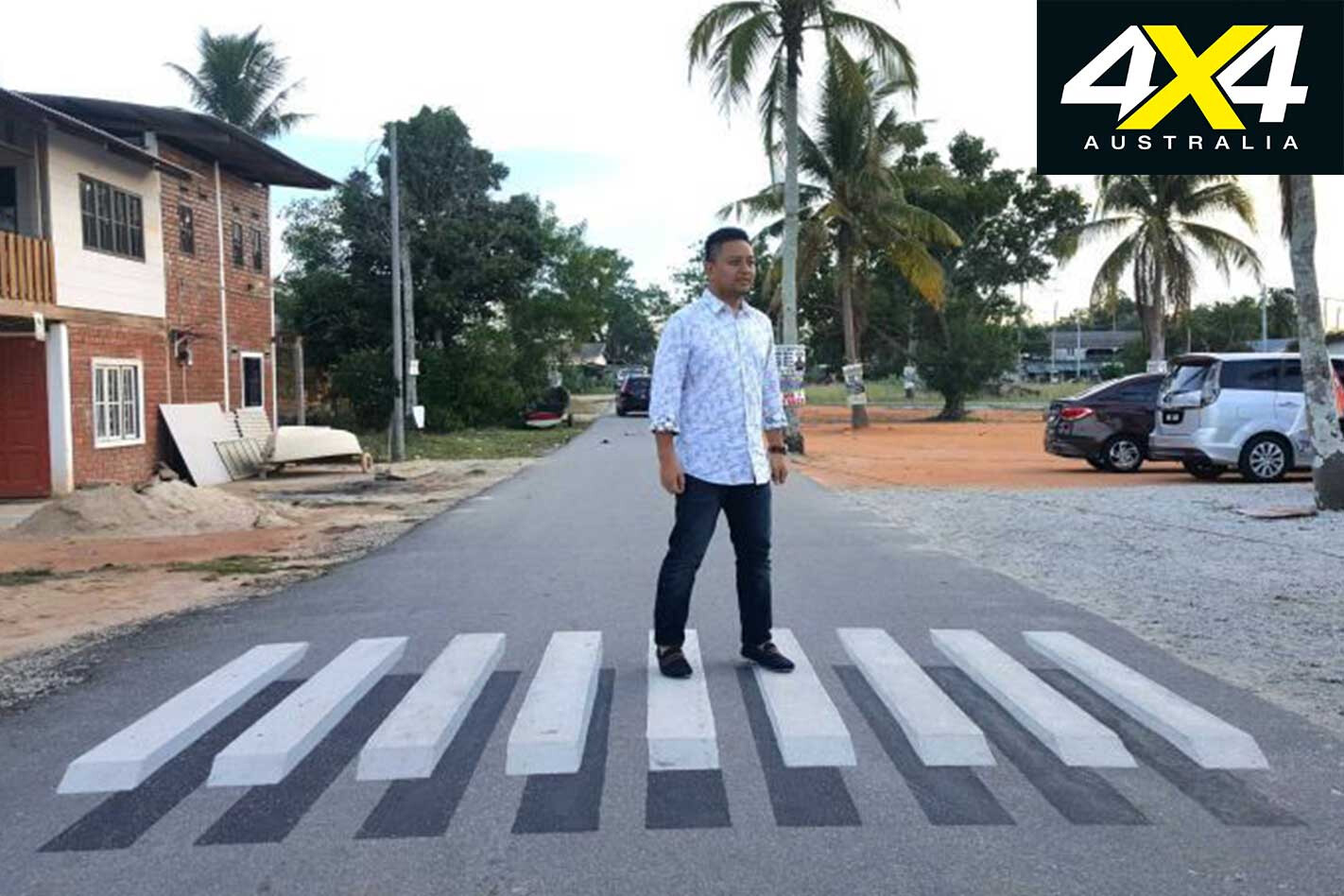
The idea was sparked when Boulia Shire Council Mayor Rick Britton spotted the crossings on social media, as Malaysia, India, New Zealand and the USA have already implemented similar crossings.
“I saw that other countries had put 3D crossings in to slow the traffic down,” Britton told the ABC. “I thought that’d be a great idea in a little outback town like ours.”
Britton also told the ABC he hoped the “optical illusion” would boost tourism in the town: “If tourists want to drive around and see our town, they’ll see this quirky zebra crossing and it’ll be a conversation piece.”
It should draw in traffic, but will it slow them down?
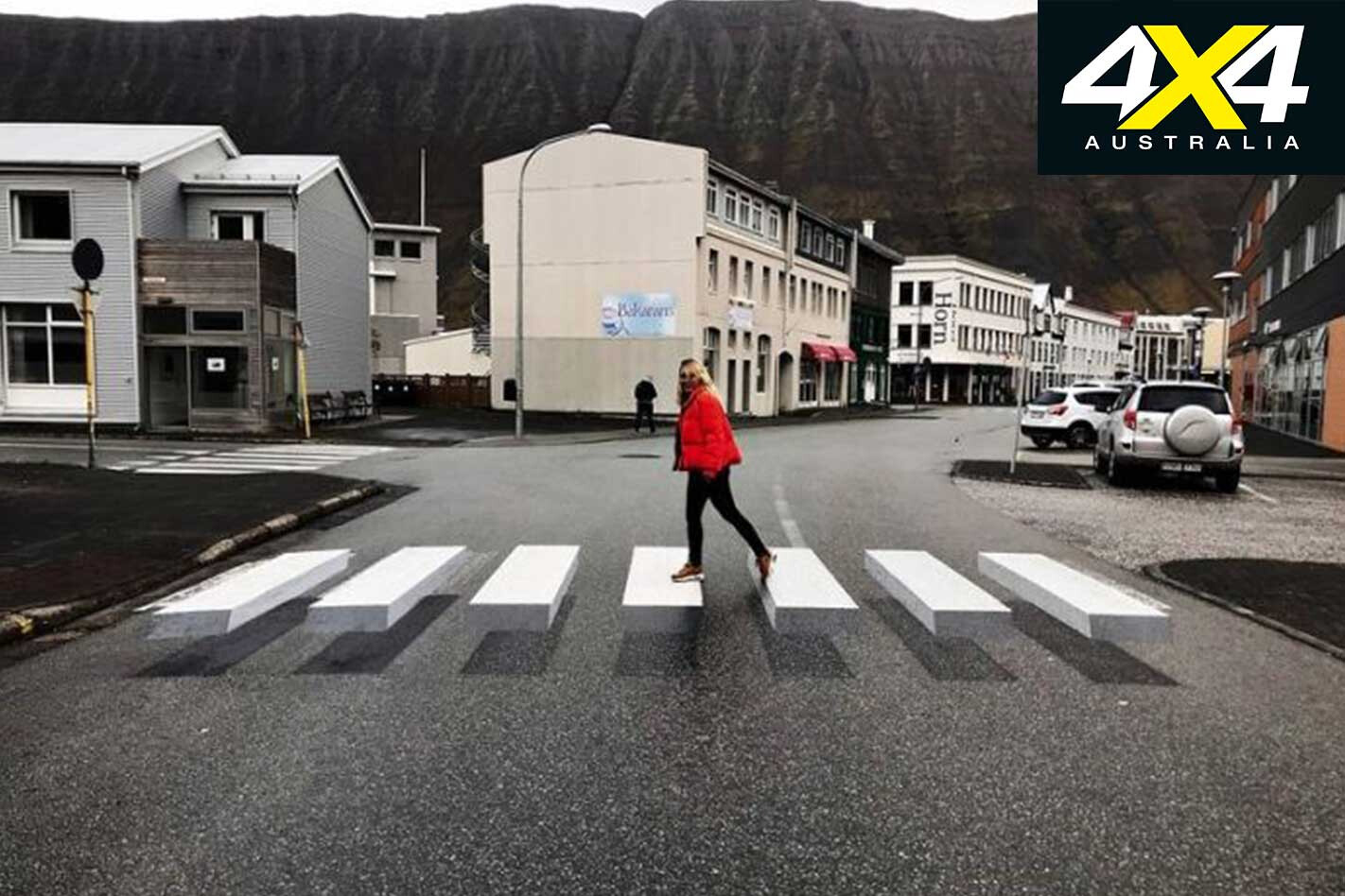
“It will be something very noticeable which can do one of two things: people might become distracted, on the other hand you’re noticing the crossing, so people may slow down,” Dr Mark King, from Queensland University of Technology’s Centre for Accident Research Road Safety Queensland, told the ABC.
“It is possible it could be distracting, but one of the things that will mitigate that a bit is that you’re looking at the pedestrian crossing, which is where the hazard is likely to lie. So at least if you are drawn by the visual image your eye is drawn in the right direction.”
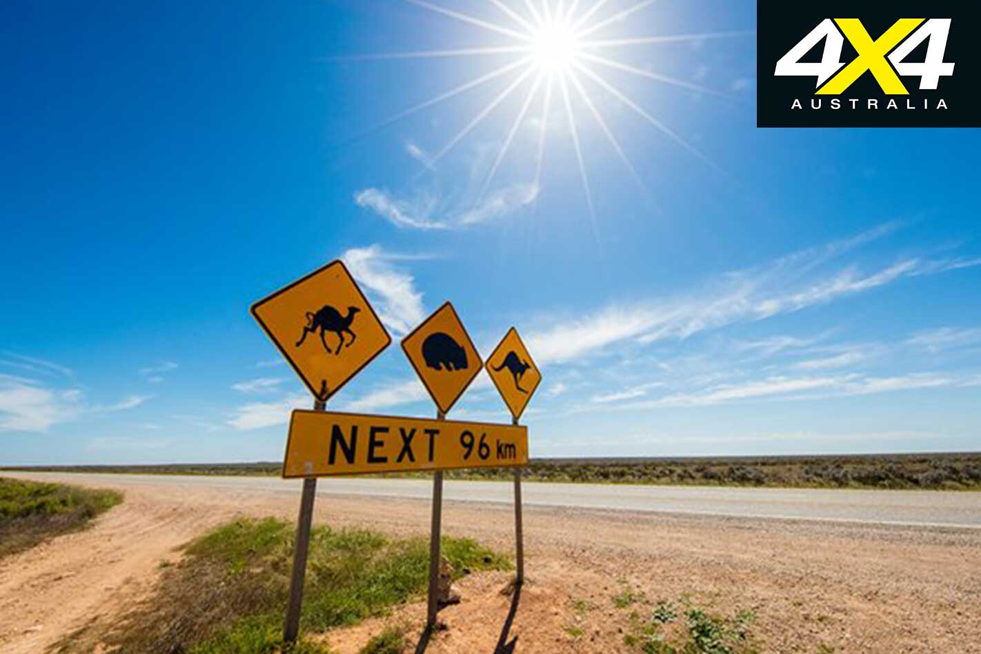
Boulia, located on the Outback Way, lies on the Burke River, which was named after Robert Burke of Burke and Wills fame, who passed through the area in 1860.
The town has a population of just 600, but many tourers chase an outback dirt pass through the town every year. Boulia is also the gateway to the Diamantina National Park, 1278km west of Brisbane.