Explore QLD
Gallery1
Anyone who has ever been to an abandoned mine site will be familiar with the scene.
There are skeletons of old buildings surrounding the mine works – smelter, brick kilns, that sort of thing. But Mount Mulligan has one big factor that sets it apart: 75 men died there in a tragedy that rocked not just the community but also the entire state of Queensland.
Mt Mulligan had been a producing coal mine since 1910. In September 1921, the entire population of working miners were ‘below’ when a massive explosion ripped through the mine and snuffed out the lives of every man underground. The cause was debated at great length, because Mulligan was noted as a ‘clean’ mine, meaning that no gas leaks had ever been detected. Eventually the explosion was blamed on the careless handling of explosives. When it blew, the ever-present coal dust caught fire and the men never had a chance. To this day it remains Queensland’s worst industrial disaster.
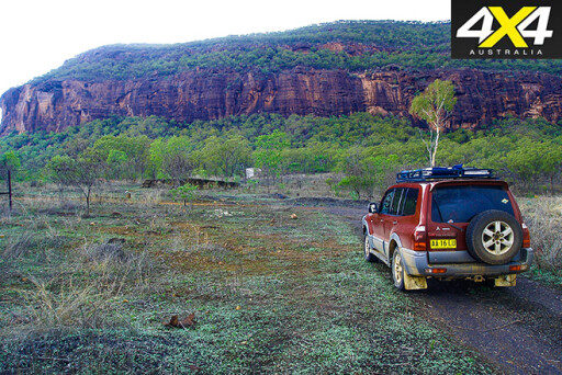
Today, as it did all those years back, the Mt Mulligan massif broods over the remains of the town. Roughly three times the size of Uluru, Mulligan is an imposing sight through anyone’s eyes. It had been known as Ngarrabullgan by the local Djungan people, then in 1874 an exploring party led by James Venture Mulligan set eyes on its magnificence. Although not the first Europeans to see the mountain, it became known as Mt Mulligan from that time on.
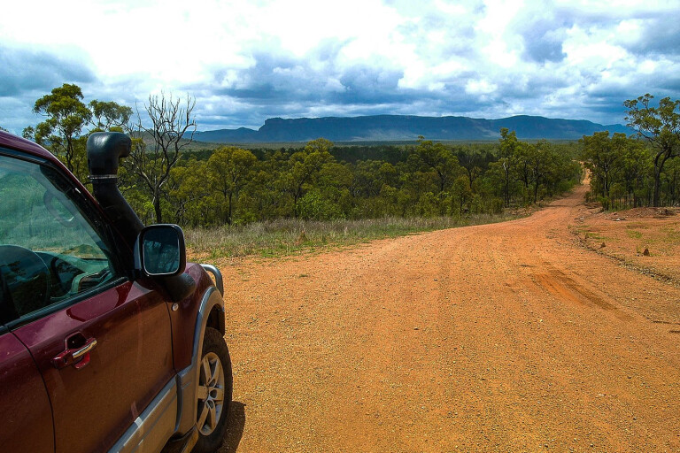
In the right sort of light the mountain’s flanks glow with a dull sheen. You usually get your first glimpse of it when you crest a rise in the track that comes in from Dimbulah. It crouches on the horizon bathed in a blue haze, standing proud above the low scrub country that surrounds it. At this point you have travelled perhaps 20km over a track that varies only in its texture. The track is corrugated for a few kilometres, then to break up that monotony some washaways are tossed into the mix along with numerous, mostly shallow creek crossings.
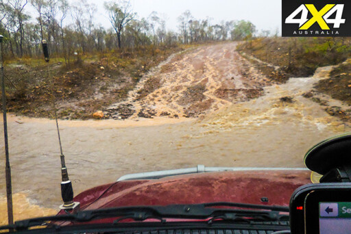
We visited the track in the very early part of the North Queensland wet season. The day was sunny and in places the track raised a modest plume of dust to mark our passing. There was of course the occasional wet patch and a few creek crossings, but they prompted little concern. The water flowed cleanly over the crossings and gave no indication that heavy rain had fallen. We marked one crossing as a possible future campsite.
 On the way in you will pass a turn-off to the old township of Thornborough. There is little left of the town these days, but its graveyard is classified by the National Trust and makes an interesting stop on your way. Thornborough was a small but thriving community and boasted an outstanding number of hotels – because mining is thirsty work. By 1924 only one pub remained, while in 1921 the post office had ceased to operate, closing finally in 1931.
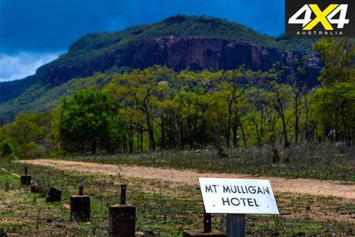
The old town-site of Mt Mulligan was reached without drama and we pulled up at the site of the old Mt Mulligan pub. The remains of the town today are mostly marked by the stumps that supported the town’s buildings. At one point some 10,000 souls lived here. Today there are a few signs that depict the buildings that had once been here, the pub being an obvious one, along with the RSL and a number of other buildings, both public and private. There was even one sign that declared the family of Denman had lived there!
 Lunch was eaten in the shade of a big tamarind tree on the site of the pub. All around us the old building stumps dotted the ground, with small termite nests competing for space, while the Mulligan massif loomed over it all. A rusting sign in the tamarind tree proclaimed that a couple of blokes called Tim and Joe had enjoyed dinner camp (lunch) there as well. We followed their example.
Most of the country around here is occupied by Mt Mulligan Station, and there used to be camping available. But that has since changed, with the station being bought out by a company intending to develop a resort here, and most of the tracks that are away from the main road in are closed. The old town site though will continue to be open to the public.
You can spend plenty of time in Mt Mulligan just wandering around looking at what remains of a once-thriving township, so it’s fortunate that the journey there is easily done as a day trip from Mareeba, or even Cairns, so you can take your time to poke around. The entrance to the old mine has long since been blasted closed, its location only marked by some old wire cable on the ground and a bit of a dent in the side of the mountain.
 Nearby and above that is the more tangible evidence of a concrete entrance to the air vent that allowed somewhat fresher air to circulate underground. Not far from there is the chimney of the smelter, in surprisingly good condition considering the ruins it presides over.
Strewn around are the constant reminders of what once was – here the remains of an old truck, there a rusted kerosene tin with a few bullet holes in it. Then there are the solid cement walls of buildings that defied those who removed most of what was moveable.
The cemetery yields further information. Many of the graves are unmarked, but others tell a story of mine mishaps and childhood illness. For many in the early days of the mine, it was clearly a tough life and old age seemed to be a fairly small factor for the majority of residents. Congratulations should go to the members of the Cairns 4WD Club who take responsibility for the upkeep on the graveyard.
 As can happen at any time in the far north, the weather changed dramatically during our visit. To the north-east, the sky had turned purple with the threat of a storm, and distant thunder reminded us that the wet was well on the way. We shelved any further exploration of the site and began to backtrack.
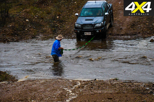
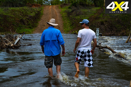
This decision turned out to be the right one. The storm had curled around on our escape route and had caused a couple of the creeks on our route to rise. One in particular needed a bit of caution, but this is all part of travel in fairly remote country. The weather often assumes control, so you must adapt. Checking out any creek or river crossing on foot is never a waste of time.
 The rain increased as we headed out along the track back to Dimbulah as rivulets of muddy water streamed into the gullies, lining the track. I spared a thought for those who had gone before, doing the same journey in much more primitive transport. A thought too for the wives and children who were left behind on the day the mine took their men.
Mission to Mulligan
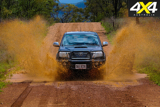
GETTING to Mt Mulligan is a fairly easy day trip out of Cairns or Mareeba. From Mareeba, it’s roughly 120km one way so, with a reasonably early start, you can be home for dinner. It should never be forgotten though that this part of Australia can throw a spanner into your plans. While the track out from Dimbulah is probably driveable in a conventional vehicle, a 4WD is a far better choice. Corrugations and the regularity of creek crossings might leave your Falcon in shreds.
For fuel, your last chance to top up is Dimbulah, while on the way back there is always the pub, should thirst be getting the better of you. Also, you should take plenty of food and water; there is nothing available at Mulligan.
 For additional info, a stop at the visitor centre in Mareeba is well worth the time. If you can, ask to talk to Mary Thompson, the local historian and absolute fund of knowledge on Mt Mulligan. Mary frequently gives talks to tour groups, but doesn’t mind a smaller audience.
The Aboriginal people of the area make up a number of clans under an overall tribal name. One group, the Wahoora, called the mountain ‘Woothakata’, which means ‘strange-shaped mountain’. White-fella names include Mt Lilly, named by William Hann in 1872. Then William Temple Clark called it, rather unimaginatively, Box Mountain in late 1873. Of course Mulligan was the only name that stuck, even though old James Venture Mulligan was said to be a little underwhelmed by the idea.
Farther on, it’s possible to travel beyond Mulligan on Kondaparinga Road to link up at Cooktown Crossing on the Mitchell River. However, there is the Hodgkinson River to cross, and both this and the Cooktown Crossing become impassable after heavy rain.
Click here to explore more of Queensland.
Please enable JavaScript to view the comments powered by Disqus.
COMMENTS