Explore NSW
Gallery19
A CHILLY wind swept up from the wide expanse of forested country stretched out below me.
This article was first published in 4x4 Australia's March 2012 issue.
I was waiting silently for the first rays of light to emerge from behind the jagged outline of Mount Warning, 15km to the east. Rich hues of red and pink painted the sky, quickly followed by vibrant shades of orange, before the sun finally rose above the mountain, spreading gentle golden rays over the eastern escarpment of the Border Ranges National Park.
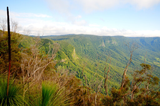
The rugged, rainforest-covered mountains that hug the NSW side of the Queensland-NSW border have been an awe-inspiring sight for train travellers on the Brisbane-Sydney line ever since the difficult pass was cut through the mountains more than 80 years ago.
 More than 1000 men toiled with picks, shovels and explosives to construct the tunnel through the mountains, resulting in the first standard-gauge rail link to join two Australian states. Situated two-and-a-half hours drive south-west of Brisbane, or a 30-minute drive north of the small NSW town of Kyogle, Border Ranges NP is one of the most spectacular wilderness regions in northern NSW.
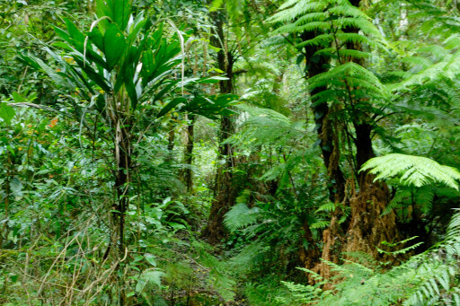
Covering an area of 31,680ha, the park protects a wide variety of habitats from low elevation sub-tropical rainforest though to cool temperate rainforest on the higher mountain slopes. In 1986, the Border Ranges was given the added protection of World Heritage status due to its wide variety of rare and endangered flora and fauna and other outstanding natural values.
European settlers arrived in the area in the early 1840s. The main attraction for these newcomers was the vast stands of timber covering the valleys in and around the mighty Richmond River. Red cedar was the prime target for these loggers who first targeted the more accessible timber growing near the river flats before turning their attention to the harder to reach cedar trees higher up the mountains.
 Small timber mills soon sprang up along the banks of the Richmond River and its tributaries to handle the massive amount of trees being felled throughout the region. The tiny communities at Grevillia and Long Creek not far from the park boundary are two of the remaining logging settlements that once dotted this remote corner of northern NSW.
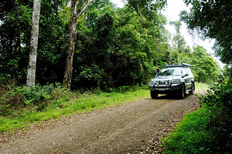
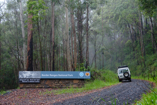
Visitors from Brisbane will generally approach from the border gate. The last kilometre of the drive up to the gate is extremely steep and provides great views over the surrounding country. The stark contrast between the almost treeless grazing country on the Queensland side and the dense rainforest of the national park just across the border gate is a reminder of the destructive land clearing that has occurred since European settlement.
Although this narrow central section of the Border Ranges NP is less than 4km wide, it gives you some idea of the diverse types of vegetation growing there. The bitumen road is narrow and very windy with many blind corners, so drive slowly and take extreme care on the bends. Make sure you stop at the Border Loop picnic area about 3km into the park.
 A track turns off to the right and heads down about 200m to a delightful picnic area that overlooks the Border Loop railway. The picnic area is equipped with picnic tables, toilets and an information board about the national park and the construction of the railway line. A short loop walk here passes through some interesting eucalypt forest.
After leaving the Border Loop picnic area the road winds down through the park for another kilometre then twists and turns through semi-cleared grazing country for a further 9km before reaching the turn-off to Symes Road and the Border Ranges NP on the left.
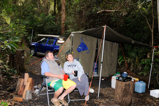
From the Symes Road turn-off, it’s a 3.2km trip through hilly terrain before reaching a junction where you turn left and drive 4.5km onto the park’s main camping area at Sheep Station Creek. Set among towering eucalypts, the camping ground is an excellent spot to base yourself for a few days while you explore the park.
 Privacy is assured in this enchanting spot as most of the 20 or so sites are well screened from each other by shrubs and small trees. Facilities include picnic tables, fireplaces, toilets, drinking water and a large shelter shed. Advance bookings aren’t necessary, as the camping ground is rarely full and operates on a first come, first served basis.
Nights at Sheep Station Creek can be very peaceful and it’s easy to be lulled to sleep by a crackling campfire while sitting back and listening to the sounds of nature all around you. During the height of summer, the din from tens of thousands of cicadas in the surrounding trees can be quite overpowering.
They in turn attract a host of predators including large huntsmen spiders, tawny frogmouths and boobook owls. The latter have an amazing haunting call that can echo through the treetops for many kilometres. Some old bushies say that the boobook owl’s mournful sound is as symbolic of the Australian bush at night as the kookaburra’s raucous laughter is during the day.
 An excellent series of bushwalking tracks through varied types of terrain is one of the main drawcards attracting visitors to the park. Tracks vary from easy, 30-minute strolls through to arduous six to seven hour walks along steep, slippery trails that are sometimes blocked by fallen trees.
Fit and experienced bushwalkers may like to venture into the remote, road-less western section of the park as many areas in here, such as Leavers Plateau, were never logged and are home to many huge ancient trees.
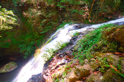
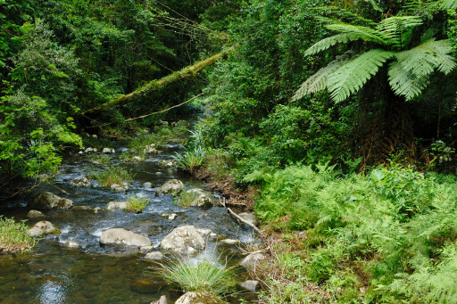
There are a couple of excellent tracks that start near Sheep Station Creek camping area, including the easy 2km return Palm Forest walk that follows an old bullock track down through eucalypt forest to Brushbox Falls. After heavy rain this waterfall is a spellbinding sight as huge torrents of water tumble down the creek and over the falls sending mist and spray in all directions.
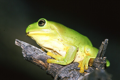
 The track continues on from the falls to a large grove of bangalow palms passing huge strangler figs and booyong trees along the way. Birdlife is prolific with eastern-yellow robins, rufous fantails, satin bowerbirds and yellow-throated scrub wrens being regularly sighted.
Reptiles are relatively common as well and you might pass a large shiny black land mullet (the world’s largest species of skink) soaking up the sun on a fallen tree, or sight a harmless carpet python slithering off into the scrub. One of the highlights of a trip to the Border Ranges is the Tweed Range Scenic Drive.
Starting at the turn-off to Sheep Station Creek, the 45km long gravel road winds up through the heart of the eastern section of the park to the ancient moss-laden forests around Antarctic Beech picnic area.
From here it follows the escarpment past a number of magnificent lookouts before plunging back down through sub-tropical rainforest finally joining up with the Kyogle-Murwillumbah road at Lillian Rock. The first point of interest along this route is Forest Tops camping area, 7km up the road and the smaller of the two camping grounds within the park.
 Set among a grassy clearing surrounded by lush forest, the site has picnic tables and a toilet and is for walk-in campers only. Drive 200m on from Forest Tops and you will come to a junction in the track. The left-hand fork up to Brindle Creek (2km away) is the better option, as it goes past a couple of small picnic areas and a lookout over the Tweed Valley before rejoining the main Tweed Range Scenic Drive about 10km further on.
This track is one-way only and can be closed (a steel gate) during prolonged wet weather. There are a couple of walking tracks and a tiny picnic area (two tables) near where the bridge crosses Brindle Creek. This enchanting crystal-clear stream cuts through luxuriant, tall rainforest full of tangled vines, birds-nest ferns, mosses and colourful fungi.
Those who are feeling energetic and have at least five or six hours to spare might like to tackle the spectacular Brindle Creek walk. This fairly arduous 10km return hike winds up through the rainforest to Antarctic Beech picnic area.
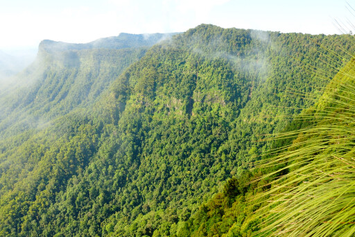
Antarctic Beech picnic area is a great spot to stop for lunch or morning tea as you can see great panoramas across the untouched wilderness of the “Lost World” and on to Lamington NP on the Queensland side of the border. Unfortunately, mist often drifts in and obscures much of the view, but it can lift just as suddenly.
 The picnic area is surrounded by a large number of gnarled, old, moss-covered Antarctic beech trees that are a magnet for nature photographers. It’s around 3km from Antarctic Beech picnic area to where the track rejoins the Tweed Range Scenic Drive again, passing by the Tweed Valley Lookout with great views over the Tweed Valley and beyond.
Another spectacular lookout is the Pinnacle. It’s a fairly steep 200m walk up through the rainforest, but the magnificent views are well worth the effort. Try and get there early in the morning if possible as, apart from taking in views almost to the coast, you can look back as the sun bathes the massive rainforest-covered cliffs that once formed part of the caldera of the long extinct Mount Warning shield volcano.
MOREdestinations
There are a few other spots that you shouldn’t miss, including Blackbutts Lookout, around 7.5km from the Pinnacle, and Bar Mountain picnic area – 10.5km away – surrounded by cool temperate rainforest, including a stand of magnificent Antarctic beech trees.
There are a couple of great walks that start near the picnic area including the Bar Mountain Circuit (3.5km) and the easy 750m Falcorostrum Loop. Lucky hikers may even catch a glimpse of the very rare Albert’s lyrebird on these tracks.
TRAVEL PLANNER
GETTING THERE
From the Pacific Highway, turn off at Murwillumbah and drive west along the Murwillumbah-Kyogle road for 38km. From Kyogle to the south, head north along Summerland Way to the village of Wiangaree (15km) then turn right and follow the signs to the park. From Brisbane, head south-west to Beaudesert then drive along the Mount Lindsay Highway for about 27km before turning left onto Lions Road.
PLACES TO STAY
There are two places to camp: Sheep Station Creek and Forest Tops. Both charge $5 per night for adults and $3 for children. There is also a vehicle entry fee of $7 per vehicle per day. Rangers regularly patrol the park. Alternatively, there are caravan parks and motels in Kyogle and Murwillumbah.
FUEL and SUPPLIES
From Brisbane it’s the Tamrookum store, 7km before you turn off the Mount Lindsay Highway. Via Kyogle, top up supplies before you leave town. From the Pacific Highway, replenish fuel and food at Murwillumbah.
MAPS
Hema’s North East New South Wales.
THINGS TO DO
Bushwalking, birdwatching, scenic drives, lookouts, waterfalls.
IMPORTANT CONTACTS
The NPWS office at Kyogle, Website: npws.nsw.gov.au Kyogle visitors information, phone 02 6632 2700. Murwillumbah visitors information, phone 02 6672 1340.
Please enable JavaScript to view the comments powered by Disqus.
COMMENTS