Explore WA
Gallery6
THE Kennedy Range National Park in Western Australia sits approximately 830km north of Perth and 150km east of Carnarvon.
The steep rubble slopes of the south-eastern side are easily accessible via formed gravel roads from Gascoyne Junction. Already well developed by WA’s Department of Parks and Wildlife (DPaW), it has a designated campground with drop toilets, while signposts lead to highlights like Honeycomb, Drapers and Temple Gorges.
.jpg ) However, the western side is a completely different story. It doesn’t have the dramatic cliffs of the eastern side, but it does have permanent springs, shady river gums, creeks and water holes. Access is on unformed tracks via Mardathuna Station to the west or by crossing the Gascoyne River from the south.
However, the western side is a completely different story. It doesn’t have the dramatic cliffs of the eastern side, but it does have permanent springs, shady river gums, creeks and water holes. Access is on unformed tracks via Mardathuna Station to the west or by crossing the Gascoyne River from the south.
There is also a rough 4WD track over the top of the range, and it’s this isolation that keeps the Kennedy Range’s western side in pristine condition.
Access to the south-west end of the range, across the Gascoyne River, can be fraught with danger and travellers should be aware that the riverbed’s sand is coarse and does not compact well when wet, so you risk your tyres sinking in the quicksand. Even when it’s dry it can be challenging.
.jpg ) Being up to 200 metres wide, if you do get stuck on the way across it could be a long reach to the nearest big tree or firm ground to winch yourself out.
Being up to 200 metres wide, if you do get stuck on the way across it could be a long reach to the nearest big tree or firm ground to winch yourself out.
Alternative access is from the west via Mardathuna Station. The Mardathuna Road passes the homestead, so it’s worth a courtesy call to the station managers to ask if it’s okay to pass through. From there, continue on to Mooka Station which will eventually lead to Pharoh Well at the base of the range.
MORE4X4 destinations
The road starts off being reasonably well-formed as far as the homestead, but from there on it varies between soft sand and rough rock, with plenty of washaways thrown into the mix.
Heading south along Mardathuna Road from Pharoh Well, travellers will find numerous permanent springs, waterholes and creeks along the base of the range waiting to be explored. The largest of these is Chaffcutters Spring, which makes a lovely, tranquil place to camp among its pools of water and towering river gums.
.jpg ) Another point of interest a bit further south is the Mookaite deposit near Mooka Spring. This is the world’s only known source of this earthy-coloured Jasper rock. While it’s well worth a fossick for this colourful gem, the rights to the mine is held by lessees, so don’t be tempted to take any samples with you.
Another point of interest a bit further south is the Mookaite deposit near Mooka Spring. This is the world’s only known source of this earthy-coloured Jasper rock. While it’s well worth a fossick for this colourful gem, the rights to the mine is held by lessees, so don’t be tempted to take any samples with you.
On paper, Mardathuna Road T-junctions with the Carnarvon-Mullewa Road, but you’ll have to cross the aforementioned Gascoyne River to reach it. If it’s too wet to cross, the area still makes a lovely spot to camp for a few days of swimming and relaxing in the shade of the huge river gums and paperbark trees.
When you’re ready to get back to exploring the Range, you’ll need to backtrack to Pharoh Well, which should take two hours, without trouble. From there, you can make the decision to travel back along the roads you came in on, or take the more adventurous route and tackle the 4WD track over the top of the range.
.jpg ) You’ll find DPaW signs along the way, advising that “the top of the Range is currently not safely accessible to visitors”, but people still attempt the crossing. It is not maintained and the runoff from any rainfall can have a significant impact on the state of the track, so a high-clearance 4WD is required, as well as lowered tyre pressures and locked diffs.
You’ll find DPaW signs along the way, advising that “the top of the Range is currently not safely accessible to visitors”, but people still attempt the crossing. It is not maintained and the runoff from any rainfall can have a significant impact on the state of the track, so a high-clearance 4WD is required, as well as lowered tyre pressures and locked diffs.
Be prepared for some track-building after recent rains, as the depth of the gullies made by runoff can make the track impassable.
It can be done, though, but it’s not for the faint-hearted. Those who are up to the challenge will be rewarded at the top of the range with a view of expansive red dunes and spinifex scrub.
.jpg ) In stark contrast to the rocky climb, once up the top it’s smooth driving along sandy wheel ruts as the track loops between the lines of dunes. Keep an eye out for the visitors’ book in its mounted metal box to make record of your crossing.
In stark contrast to the rocky climb, once up the top it’s smooth driving along sandy wheel ruts as the track loops between the lines of dunes. Keep an eye out for the visitors’ book in its mounted metal box to make record of your crossing.
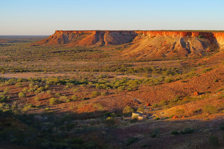
You’re not out of rocky territory yet – as you approach the eastern side, the track soon turns rough again, however, this is where you’ll find the crowning glory of the trip with the spectacular views it offers. Make sure to take it in.
The track traces right along the edge of plunging mesa cliffs, and the most difficult decision you’ll have to make is choosing which spot to set up camp so you can sit and watch the changing colours as the sun slowly sets.
It’s for moments like these, in locations like this, that you own a four-wheel drive!
Please enable JavaScript to view the comments powered by Disqus.
COMMENTS