Explore NT
Gallery30
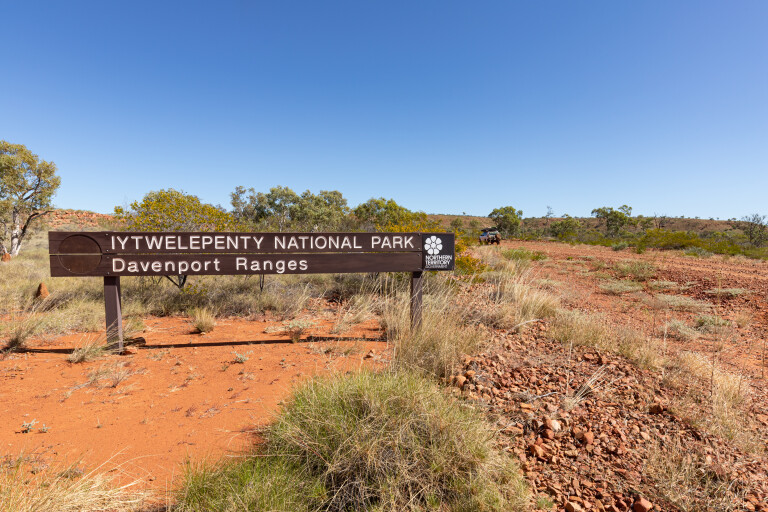
There’s a sign on the Stuart Highway, just north of Karlu Karlu (Devils Marbles), pointing to the Iytwelepenty/Davenport Ranges National Park and it’s passed by thousands of vehicles a day. Very few people take the turn-off and explore this stunning destination, which is a bonus for those of us who love remote destinations like this.
Kurundi Road leads to the scenic Iytwelepenty/Davenport Ranges NP, complete with permanent waterholes, great bush camping options and a challenging 4WD loop track. It’s also a haven for birds and fish.
The Davenport Range and nearby Murchison Range are unique to the other ranges in Central Australia because they receive relatively reliable rainfalls during summer. The Davenport Range also sits far enough north that it gets affected by the northern wet-season weather.
30
The region also enjoys warmer winters and a more humid climate than anywhere else in the Red Centre, which means there are several unique plants that include a mixture of tropical and desert species.
With its rugged beauty, Iytwelepenty is a photographer’s heaven, and its remoteness means you should be the only ones there.
Devils Marbles Hotel
I spent the night at the Devils Marbles Hotel, Davenport, where the beer was as cold as the pool, the chicken parma outstanding, and the bacon and eggs the perfect way to start the day. Hitting the road early is how I like to roll, avoiding the grey nomads towing oversized caravans slowly along the highway. There were plenty hanging out at Karlu Karlu and the Bonney Well Rest Stop.
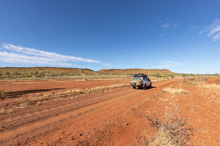
Turning on to the gravel Kurundi Road, I dropped some air out of my tyres. In these conditions, I like to start the Kumhos at around 24psi in the front and 28psi in the rear, as the ride is significantly better, especially on corrugated sections.
As the road twists through a small range, the going is slow and rough. It’s only 50km to Kurundi Station, which has a store open seven days a week from 9am to 5pm with fuel, groceries, cold drinks and more.
30
Once past the short bitumen strip through the pass, the dirt road widens as it turns east across the plains. Just 17km past Kurundi, the signpost for Whistleduck Creek Road leads to the campground and gorge. The campground is in two sections along Whistleduck Creek, with pit toilets, firepits and tables.
Remember to book a campsite online before you arrive. A day visitor area has a shelter and table, and is only a short walk to Irrmweng Rockhole, a place to enjoy the scenery and birdlife.
After spending a couple of days relaxing in the shade of the gum trees, it was time to move on. I hadn’t seen another soul in my time here, which is part of the magic.
360 lookout
Retracing my steps to Kurundi Road and turning right towards Epenarra, it was good to see the red dust billowing behind the Prado again. Just a short way before Epenarra is Cloughs Bluff Lookout, and the short, steep drive to reach the top is well worth it. The space is rather flat, with a table and chairs, but the 360-degree views make this a special place to stop.
The road from here was in the process of being graded, so whilst smooth, speed was restricted. On reaching a tight right-hand bend, the track to the left leads to Epenarra Station which offers fuel and a store with a good range of supplies, hot food and free camping.
The staff are very friendly and happy to direct you to some great bush camps next to the Frew River. Telstra 4G is available here, and you can find out what the conditions of the tracks ahead are like, as Binns Track follows this same route.
30
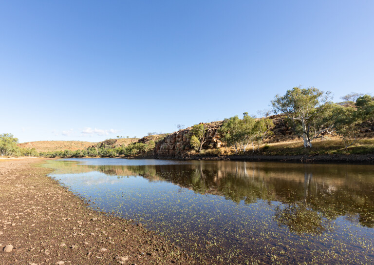
The turn-off to the Old Police Station Waterhole is approximately 33km from here and, once the Frew River had been crossed, the gravel road was in decent condition with some corrugated sections. I really enjoy the drive to the waterhole, especially in the late afternoon when the sun bounces off the rugged outcrops.
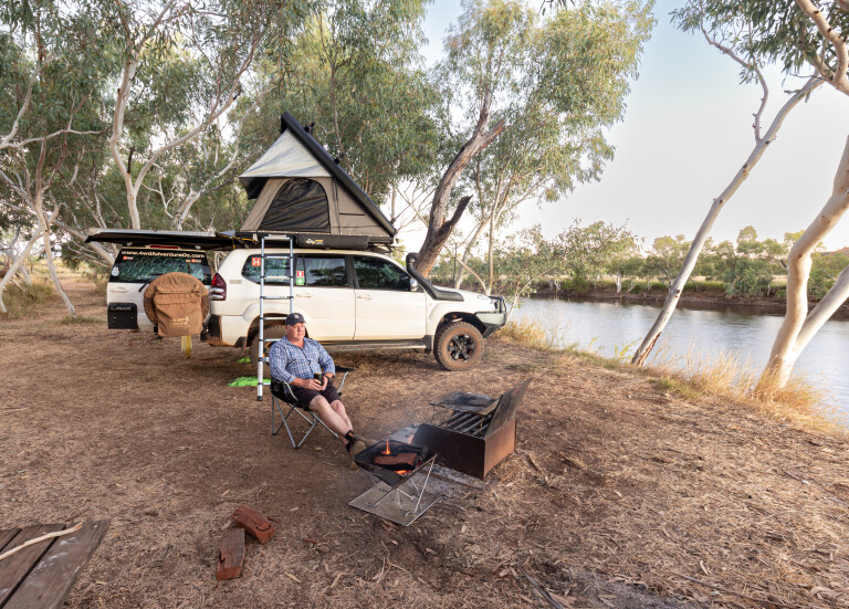
There were a couple of groups set up at the first couple of campsites, so I drove to the end of the track to find an excellent spot amongst the saplings. Each site contains a firepit and there are a couple of drop toilets a short walk from all sites. There was plenty of water in the waterhole, and I enjoyed watching a large flock of budgerigars diving in to take quick drinks as the sun began to set.
I was awoken during the night by the sound of a rogue cow trampling through the long grass along the stony riverbed, before slurping from the waterhole. By morning, it had disappeared with the only evidence of its existence being cow dung that the hordes of resident flies enjoyed.
Frew River
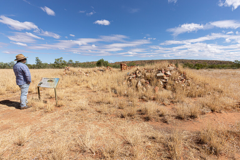
On the opposite bank and a nice walk from either end of the campground, are the ruins of the first Frew River Homestead that was abandoned in the 1890s due to continual conflicts with local Aboriginal warriors and a long drought. When cattle arrived in the Frew River area in January 1889, it changed the lives of the local Alyawarr and Wakaya people dramatically. This was an important place from which they camped, fished and hunted for thousands of years, so conflict was inevitable.
When tungsten was discovered at Hatches Creek, hundreds of miners arrived to work the fields. A police presence was proposed when troubles arose in the 1890s and a mining warden was needed for the mines.
Constable Jones arrived in December 1918 and a police station was soon built on the site of the old homestead. The police presence didn’t last long past the end of World War I, when mining at Hatches Creek petered out and on September 4, 1921, the last constable closed the station.
30
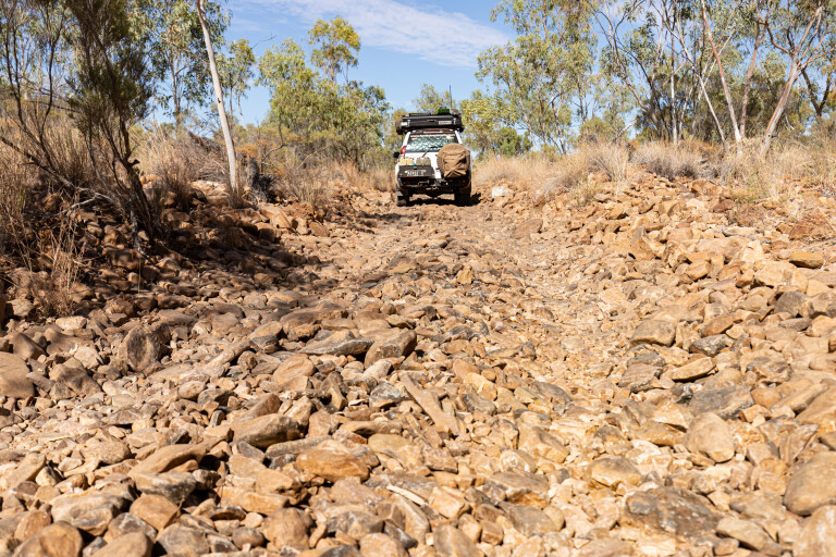
If you enjoy some 4WD action, the Frew River 4WD Track is a good challenge and trailers aren’t recommended. The loop track takes you through some dry creek beds before you reach the bush camping areas by the waterhole. There are no facilities, so leave the place better than you found it. The waterhole had receded since my last visit but the views across to the colourful cliff face on the opposite bank were still excellent.
Once past the camping area, it’s not long before you start to climb the range. One section is best to walk first to help in choosing the right line, as it’s quite steep with lots of small rocks that can increase the chance of wheel slippage. Past this section, you’re then following the ridgeline with outstanding views across the range. There are plenty of spots to stop to get a better look; don’t forget the camera.
The 4WD track may only be 17km but it is slow going, so allow at least a couple of hours to take in the epic landscape. The track ends at a gate before the junction with Kurundi Road. Take a left to head back to the Old Police Station Waterhole, around 51km away. This section of Kurundi Road is less well-maintained, with plenty of washouts, corrugations and bulldust holes to contend with.
30
There’s an old windmill at Bull Creek Bore just off the track that is worth checking out, and if you need firewood there are some good opportunities before reaching the turn-off to camp. Now that you’ve explored as much of the park as you can, why not spend a few days relaxing by the water. If you decide a swim is in order, the good advice is not to jump or dive into the water as there could be submerged rocks and logs.
When it was time to hit the road again, I ventured back to Kurundi Road and turned right towards Hatches Creek. Keep an eye out for wild donkeys, and if you don’t see them, stop and listen for them braying, especially near Hatches Creek Outstation. There is still evidence of mining activity in the area, but take care if you decide to take a walk around the ruins as there are backfilled shafts that are difficult to spot. Around the next corner, an old headframe is fenced off and looks like there has been some recent mining going on.
From here, the road becomes rougher and is hard-going on vehicles and camper trailers. You’ll cross the Frew River several times as the track follows its path and eventually reach another beautiful waterhole. Once through the rocky riverbed, you’ll reach a gate that indicates the border of the national park.
An excellent remote destination for those who love adventure and want to experience a place unique to the Territory
Once through the gate (leave it as you found it), be alert for cattle hiding amongst the trees, they are young and jumpy and ready to run in front of you. Upon reaching a second gate (the same rule applies) you’ll find yourself at the junction with Murray Downs Road. If you’re following Binns Track, turn left as the quickest way back to the Stuart Highway is via Murray Downs Road, with fuel available at Ali Curung/Warrabri if you head this way.
Iytwelepenty/Davenport Ranges National Park is an excellent remote destination for those who love adventure and want to experience a place unique to the Territory. Managed jointly by Alyawarr and Wakaya people and the NT Parks & Wildlife Commission, there is a whisper that more of the park might soon be opened up for us to explore.
Travel Planner
Where
Iytwelepenty/Davenport Ranges National Park is located south-east of Tennant Creek and can be accessed via Kurundi Road from the Stuart Highway in the north or Murray Downs Road in the south.
Camping
There are three camping areas: Whistle Duck Creek, Old Police Station Waterhole and Frew River on the 4WD loop track. All campsites must be booked and paid for online before you go: www.nt.gov.au/parks/find-a-park/iytwelepenty-davenport-ranges-national-park
Permits
No permits are required.
Fuel
Wauchope and Ali Curung provide unleaded/opal and diesel fuel. Expect to pay top dollar for fuel at the remote places, with $2/litre and more for diesel.
Best time to visit
From June to September, as the weather is generally cooler and the wet-season waters should have receded.
More info
Paper maps, with the Hema Maps range providing excellent coverage. Some form of electronic navigation/mapping hardware/software is also recommended. Wikicamps is excellent for showing where all the good campsites are.
Please enable JavaScript to view the comments powered by Disqus.
COMMENTS