Explore WA
Gallery23
DOES your holiday checklist include beach and bush, fabulous scenery, fun activities and demand interesting tracks to punt the fourby along?
This article was first published in 4x4 Australia's May 2012 issue.
Then it’s time you headed three hours south of Perth to the Margaret River wine region. Given the travel distance, the region lends itself better to a mini-break than a weekender, unless you pack light and choose a bush eco-cabin, farm-stay, B&B, hotel, motel, apartment or five-star resort – depending on your style and budget.
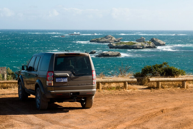
 The caravan parks here are near sensational beaches. Assuming you’re fully kitted for unassisted stays, choose a well-maintained bush camp managed by the Department of Environment and Conservation (DEC). We focused on travelling top to tail along the south-west edge of Oz, from Cape Naturaliste in the north to Cape Leeuwin in the south.
The northern cape forms a neat triangle of attractions, with the Cape Naturaliste lighthouse at the peak and two potential bases for your trip – Dunsborough and Yallingup – filling out the corners.
The bustling tourist town of Dunsborough, on Geographe Bay, guards the entrance to the beautiful and rugged Leeuwin Naturaliste National Park that stretches 120km from Bunker Bay in the north to Augusta in the south.
 The major features of the area were named in 1801 as two French ships, the Geographe and the Naturaliste, explored the southern land collecting, at the time, strange new plants and animals and seeking to make contact with the native people.
Baron Hamelin, the captain of the Naturaliste, was given much credit for the success of the trip because he was prepared to risk his vessel in stormy waters, sailing into uncharted bays and river mouths to permit surveying and scientific investigation.
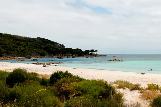
A visit to the top of the cape is a full day of activities, so head out of Dunsborough early, and drive up the right side of the cape through coastal bush scrub along Cape Naturaliste Road. Take a right-hand detour down to the clearly signposted turn-offs to Eagle or Bunker bays; both offer stunning, sheltered beaches perfect for swimming and snorkelling.
 If you’re towing a tinnie, head out for some fishing or to Point Piquet to dive on the Destroyer Escort HMAS Swan that was scuttled in 1997 after 10,000 hours of hard work by hundreds of volunteers. It now forms a spectacular artificial reef with 12 moorings.
Private boats need a dive permit, obtainable from the Busselton or Dunsborough visitors’ centres. Pick up a tourist map while at the centres for a full list of regional attractions. Since 1844, at least 12 ships have come to grief in the strong currents and dangerous reefs off the sharp tip of Cape Naturaliste.
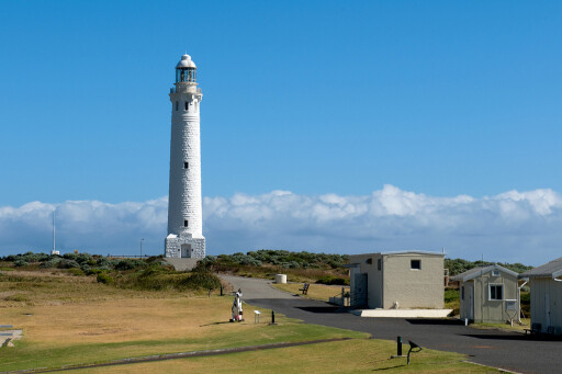
The protective guardian warding away ships was built in 1903 from limestone quarried from nearby Bunker Bay; the top of the lighthouse is 123 metres above sea level.
 It is Australia’s most accessible lighthouse with only 59 steps to the top; the views across the cape and the Indian Ocean are spectacular and the tour guides pleasant and knowledgeable, offering fascinating facts about the isolated life of the keepers who were often exposed to serious occupational hazards – such as the mercury in which the heavy lens of the light was floated to reduce friction.
Mercury vapour was the most likely cause of the madness that regularly afflicted keepers, although the insanity was originally blamed on the absence of human companions. Mercury definitely caused at least one loss of life at Cape Naturaliste. During construction, a heavy jar of mercury was lost overboard during unloading at Quindalup jetty.
A sailor dived into the rough seas to retrieve the valuable cargo but drowned in a futile attempt to find the jar in the murky depths. Stunning scenery rewards on the 1.3km walk out to the tip of the cape along flat sandy tracks. Take binoculars to view seals sunning themselves on the rocks or to watch whales frolicking in the ocean.
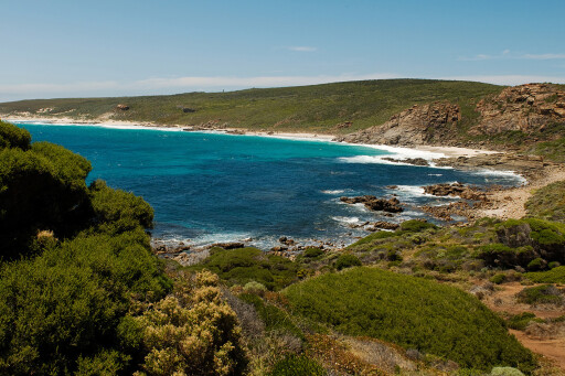 Hundreds of whales travel close to the coast from June to December. Humpbacks and southern right whales are most common, although enormous blue whales are regularly spotted. If you’re in the mood for a serious hike, start down the 135km Cape-to-Cape track that runs along the spine of the Leeuwin-Naturaliste Ridge.
It alternates between spectacular sweeping cliff-top views, stretches of pristine beach, meandering paths through sheltered bush and the breathtaking tall-tree splendour of the Boranup karri forest.
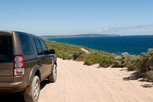
Allow at least five days to tackle the challenging track, or hike smaller stretches leaving from regular access points between Cape Naturaliste and Cape Leeuwin. For a faster trip between the capes, head back down Cape Naturaliste Road and turn right into Sugarloaf Rock Road.
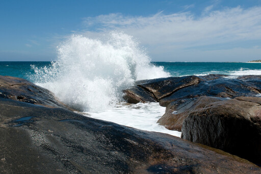
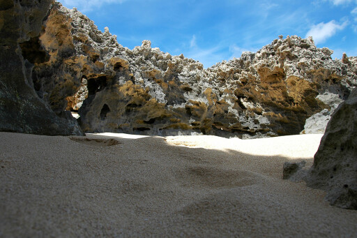
 Sugarloaf is among the most photogenic spots along the coast with impressive rock formations pounded by tumbling ocean waves spraying 30m into the air. Skilful divers will enjoy the deep narrow gully between the rock and mainland on the rare occasions when the sea is calm, with extensive reef to explore, prolific sea life and exceptional visibility.
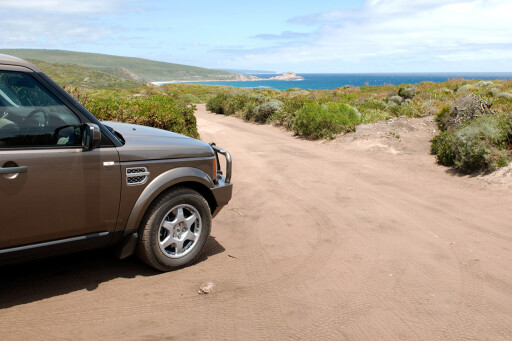
On the southern side of Sugarloaf Rock Road, 400m in from Cape Naturaliste Road is the first taste of genuine 4X4 track on the cape. Three Bears Track will defeat the most determined two-wheel driver, unless they have the skills of Mika Hakkinen. However, fourbies should have no problem on the soft sand and rocky ledges.
It offers a few challenges without any major risks – just take care on all tracks in the region for sharp limestone outcroppings that have been known to stake a tyre of the unwary or over-confident. There are no confusing side tracks that don’t show up on a map, just follow the track until you get to one of the region’s most popular surf beaches.
 Three Bears is so named because it comprises three waves of reducing size and difficulty and – you guessed it – they’re known as Papa Bear’s, Mama’s, and Baby’s. The track to the south of the beach is a longer run than off Sugarloaf Rock Road, again sandy trails with a bit of limestone.
Conveniently, the track comes out on Hemsley Road – home of the Bush Shack Brewery. This family-run microbrewery offers an array of beers to suit all tastes. Hemsley Road leads back out onto Caves Road – Dunsborough to your left and Yallingup to the right.
If the light’s not fading and the energy levels are still up, Ngilgi Cave is the first of the stunning caves open to the public along the aptly named Caves Road, which runs most of the way down the coast to Cape Leeuwin.
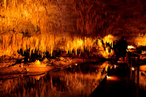 Originally known as Yallingup Cave, Ngilgi offers a range of tours from semi-guided walks through to full-on adventure crawls deeper below the surface. The most common story of the start of the mammoth tourism industry in the area is of Edward Dawson stumbling across the cave while searching for a stray horse in 1899.
He started hosting guided tours in 1900 and the cave’s popularity saw it installed with electric lights in 1903 and resulted in the establishment of the historic Yallingup Caves Hotel in 1905 to cater for the fascinated crowds travelling to the area.
Ngilgi has been the site of two world cave-sitting records, numerous weddings and local legend has it that Dame Nellie Melba gave a concert there before she went on to become a world-famous opera singer. Around the bend from Ngilgi, Caves Road continues down the coast, or you can head into Yallingup for the night.
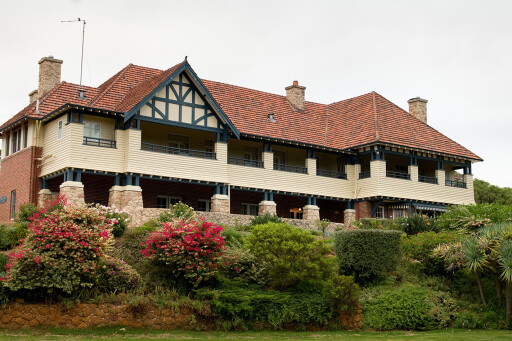 Absorb the history of the Caves Hotel and have a meal in the shady beer garden, lux out at the modern Seashells Villas, or set up at one of the two tidy caravan parks. Caves Road twists down south at a leisurely pace. During peak season, traffic is steady with few opportunities to pass, so be patient and enjoy the drive.
It’s less than 100km from Dunsborough down to Augusta, but with so many choices of things to do along the way, you’ll have to choose some highlights on each trip to the region. The Wardan Aboriginal Cultural Centre offers a fascinating insight into the culture and history of the traditional landowners of the region.
Developed and run by the local Wardandi people to promote reconciliation and community understanding, it includes an interpretive centre with traditional clothing, artefacts and weapons that permit some hands-on activities, plus an indigenous art gallery. Time to head out to the beach.
 Turn right into the clearly signposted Contos Road towards Lake Cave. With 350 steps down to the cave entrance, be prepared to catch your breath a few times on the way back up. The lake inside the cave acts as a perfect mirror, with the reflections of crystal formations doubling the beauty of the scene.
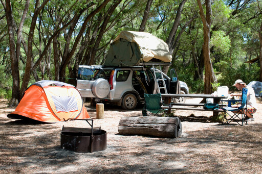
Take the left fork to head down Contos Road on 1.7km of bitumen to the excellent DEC-managed Contos Field campsite. Unfortunately, the sites can’t be booked in advance and fill up during peak holiday periods. They provide a great range of spots for tents, campers and caravans.
For the most peaceful camp zone in the area, head left off Contos Road down Point Road, about 5km in from Caves Road. It’s 2km down a narrow 4X4 track that can be rocky and require good clearance to the 10 Point Road campsites. Your most active neighbours are likely to be the local brushtail possums who become very lively at dusk.
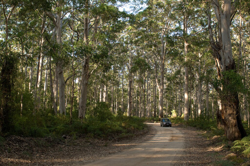 A southern brown bandicoot or two may also make an appearance to say a shy hello. No caravans, but 4X4 campervans are okay. Turn right into Georgette Road, approximately 200m south of the campsite. The narrow 4X4 tracks meander through the tranquil Boranup Forest.
Drive slowly; the single-lane tracks offer few opportunities for passing, so expect some reversing if you meet an oncoming vehicle. Boranup Drive is a well-graded tourist drive that parallels Caves Road and provides 2WD vehicles with the opportunity to access lovely picnic spots, the Boranup campsite and take in the splendour of this isolated patch of karri – the tallest-growing hardwood tree in the world.
What you see is regrowth of about 100 years – the last mill at Karridale closed in 1913. Head south down Boranup Drive to return to Caves Road. Turn right to continue the journey to Cape Leeuwin with two worthwhile detours to consider. The first is the poorly signposted Reserve Road – known to locals as Bob’s Track.
 It’s 600m north of Bushby Road and 3.9km from the Hamelin Bay-Caves Road intersection. Definitely 4X4-only, the track provides the best beach access for a fourby along the coast. The track heads up over a craggy limestone ridge with careful foot-printing essential. It becomes a sandy track as it nears the beach, 3.6km from the main road.
As the track runs due west, it’s best not tackled late afternoon when you’re heading into the setting sun. Boranup Beach is well worth the drive. It’s the longest continuous beach along this coastline, sweeping up from Hamelin Bay in the south to North Point. Hamelin Bay is a peaceful open bay renowned for its profusion of friendly stingrays.
Being surrounded by stingrays measuring up to two metres across is an amazing experience; or you can stay in the shallows as the stingrays come close to feed on scraps tossed by obliging fishermen. From Hamelin it’s a short drive down the Bussell Highway to Augusta on the Blackwood River estuary.
.jpg ) Augusta was originally settled in 1830 as a farming community. It was largely deserted when better farming lands opened up to the north in the Vasse district, and re-established on the back of the timber trade until that too faded early in the 20th century. It’s now a relaxing holiday destination for tourists, with a strong local population of retirees and weekenders.
Augusta was originally settled in 1830 as a farming community. It was largely deserted when better farming lands opened up to the north in the Vasse district, and re-established on the back of the timber trade until that too faded early in the 20th century. It’s now a relaxing holiday destination for tourists, with a strong local population of retirees and weekenders.
Flinders Bay houses the Whale Rescue memorial to commemorate Augusta’s magnificent volunteer achievement in 1986 of successfully returning to the sea 96 of 114 beached false killer whales. The Cape Leeuwin lighthouse, built where the Indian and Southern oceans crash together, marks the tail of our trip.
Top 5 fishing spots for weekend getaways
Sparkling blue under summer skies, or grey-green thumping surf spearing foam skyward in winter, fills the almost 360-degree view. While there, check out the historic water wheel. Originally built to pump fresh spring water to the lighthouse, the minerals in the still-flowing water have petrified the entire wheel into eerie stillness.
Now, time to decide which are your favourite spots to re-visit and to plan your next trip to take in all the other locations you just couldn’t fit in.
TRAVEL PLANNER
GETTING THERE
Around three hour’s drive from Perth down the Kwinana Freeway to Mandurah and efficient, but visually tedious, Forrest Highway link to Bunbury.
WHERE TO STAY
Check out regional websites for options. With short distances, it’s possible to stay at the top, bottom or middle of the region and daytrip in any direction. Tourism website margaretriver.com has great search tools to find details on accommodation and local attractions.
For information on bush campsites such as Conto’s, Point Road or Boranup, visit dec.wa.gov.au/campgrounds.
MAPS
Hema’s Western Australia 4WD Top 50
BEST TIME TO VISIT
Summer is the only time for swimming in the cool waters – with the strong prevailing winds moving inland as a natural airconditioner keeping the region much cooler than Perth. Spring is best for wildflowers. Winter can be cold and wet.
Please enable JavaScript to view the comments powered by Disqus.
COMMENTS