Explore WA
Gallery1
In fact the whole south-west corner of WA is special. Many of the coastal place names are French - a legacy of the early French explorers who bumped into the west coast of Australia in their search for new lands. It’s a reminder of how close we came to speaking French instead of English!
Perth is a long, long drive from Melbourne so, with time an issue, we flew into Perth on a warm spring afternoon, picked up a hire car and headed south. Through the roadside trees there was the occasional glimpse of a brilliant orange sunset as the setting sun dropped below the horizon of the Indian Ocean.
Our destination for two nights was Dunsborough 250km south of Perth to see if the famous Cape Naturaliste coastal scenery lived up to its reputation. Dunsborough is a quiet, laid-back, country town for most of the year, but it’s a popular summer holiday destination with many rental properties owned by absentee Perth landlords. Dunsborough has at least one famous resident.
 If you’re passing through town make sure you drop into Christian Fletcher’s gallery for THE best exhibition of landscape photography anywhere in Australia. While Christian’s name might not be well known outside photographic circles, his images are. He is arguably Australia’s top landscape photographer with a string of awards to his name including both Western Australian and Australian Landscape Photographer of the Year in 2011.
While some of Christian’s images sell for thousands of dollars and grace board rooms around the country, he’s worked hard to get where he is - including washing dishes to pay for his photography in years gone by.
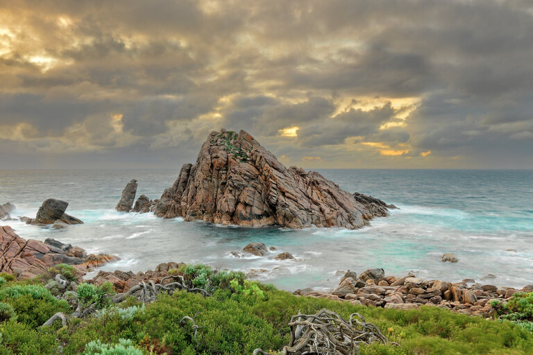
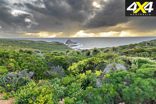
After a sumptuous breakfast in one of the local cafes we headed out to Leeuwin - Naturaliste National Park. The road to Cape Naturaliste passes a turn-off to Sugar Loaf Rock, 2km to the east on the coast. This outcrop of rock is one of the most photographed locations in WA and well worth a visit.

September to December is whale watching season as it’s this time of the year that these huge mammals come in close to shore to breed and protect their young from the predators in deeper waters.
A whale watch boat tour from Dunsborough enabled us to get up close and personal with three Southern Right Wales less than 500 metres offshore. A female and calf in the company of a male, they seemed quite unperturbed by our presence and at one stage even came in closer to have a better look at us (at 80 tonnes and the size of a bus this can be a bit worrying).
Surprisingly, there is no food for these whales in the waters off the south-west coast of WA and the adults possibly won’t have eaten for six months. Despite this the mother whale produces some 300 litres of milk a day for her calf, fattening it up in preparation for their migration further south into much colder waters. Only 10% of calves survive to maturity, although once fully grown they have no natural predators.
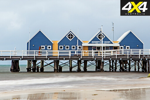 If based in Dunsborough for a few days you might also want to visit the famous Margaret River wine district 46kms south. If you are missing the bright lights, the city of Busselton, famous for its two kilometre wooden jetty, the longest in the Southern Hemisphere, is 23km to the east.
From Dunsborough our drive south-east towards the Stirling Range passed through tracts of State Forest and National Park. While heavily logged in years gone by, we saw several stands of Karri - a truly impressive tree with their huge smooth trunks reaching skywards.
It would be easy to spend several days in any number of locations in the south-west with walks, waterfalls and other points of interest in abundance. At Pemberton, roughly halfway to the Stirling Range, we took a 27km detour to the fishing village of Windy Harbour near Point D’entrecasteaux. A lookout above Windy Harbour has expansive views of the Southern Ocean and it was immediately obvious how the place got its name.
 The sound of the wind and boiling sea was truly awe inspiring - like a monster trying to tear down the cliffs that were stopping its northward journey. The wind racing up the cliff face and over the top was almost impossible to stand up against. Looking at the waves crashing over the rocks at the base of sheer cliffs it’s easy to understand why so many old sailing ships perished on these shores and why there were so few survivors.
After heading east to Denmark we turned inland and travelled through drier woodland to the small regional town of Mount Barker. Here we stocked up on supplies for the next few days and refuelled before travelling the last 20km to our destination.
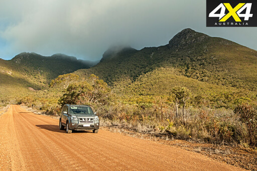
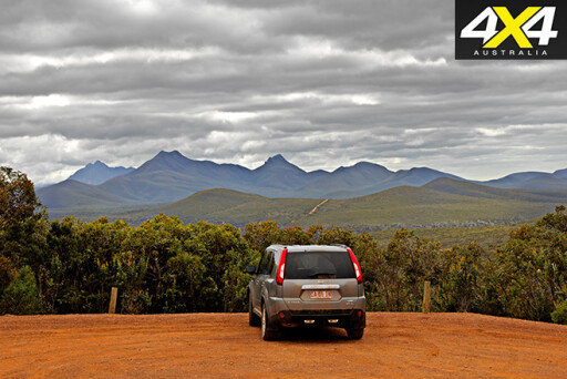
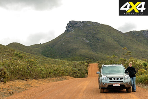 The craggy peaks of the Stirling Range rise abruptly from the surrounding plains and make an impressive sight when approaching from the south. They have a very unusual appearance, different from anything else I’ve seen in Australia. With very few taller trees to break the otherwise low dense shrubbery that hugs the valleys and ridges, from a distance the hills look as if they have been neatly clipped.
The Park has only one camping ground, Moingup Springs, in the centre of the Park on the main Chester Pass Road. Non-campers and those seeking a little more in the way of facilities generally stay at the Stirling Range Retreat 11km further north. A roadside cafe near the Retreat offers eat-in and takeaway meals.
The Retreat, owned and operated by Tony and Ayleen Sands, provides basic supplies (frozen bread etc). There is a range of accommodation options including powered and unpowered camp sites, on-site vans, motel style family rooms, and rammed earth cabins.
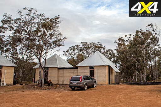 We chose one of the rammed earth cabins and found it functional and cosy with its reverse cycle air-conditioning. I was reminded of the “make do” approach required when living in the bush while recovering a book I had lost under the bed. At some time in its past one of the bed legs had broken and been replaced with suitably shaped piece of tree branch!
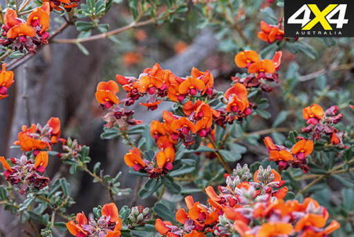
The Retreat is set on 35 acres with several easy walks that allow visitors to explore the surrounding bush. While the wildflowers steal the show many of the eucalypts and other native trees also sport showy masses of flowers. There’s no shortage of bird life seeking either insects or nectar from the abundant flowers. Almost every day a flock of the endangered short-billed black cockatoos would descend on the Retreat raucously arguing with each other at every opportunity.
We’ve all heard stories about the beauty of the WA wildflowers, but nothing prepares you for the reality. Wherever you look something is flowering and every step taken uncovers another unfamiliar bloom. It is hard to believe the kaleidoscope of colour as wildflowers seem to try to outdo each other for the showiest bloom.
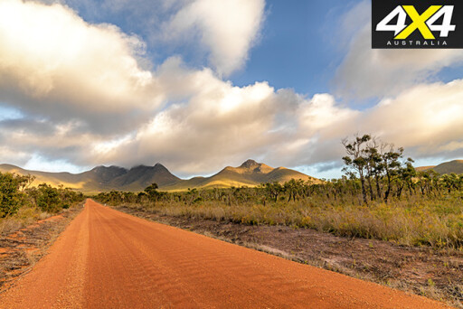 To protect the delicate environment and sandy soils there is little public vehicle access to tracks in the Park. The main sightseeing road is the 115 km Stirling Range Drive that loops through the Park. This two-wheel drive gravel road runs east-west through the centre of the Park and then back along the northern boundary. Every corner brings amazing scenery with rocky ranges, some cloaked in mist, rising steeply on either side of the wildflower fringed road.
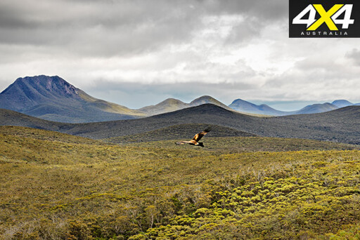
In the centre of the Park on the Stirling Range Drive there is a small car park with a walking track that follows the ridge 400 metres to a lookout. While taking in the view, the tranquillity of the moment was suddenly lost as a wedge-tailed eagle silently glided up over the lip of the ridge only metres away. With a wingspan of more than two metres these are truly impressive birds.
It took me a few seconds to have the presence of mind to point my camera in the general direction of the bird and grab one quick shot as it continued slowly on its way. While I wish I’d reacted more quickly, with the distinctive Stirling Range in the background this photograph is probably my favourite from the entire trip.
 From the main road near the Stirling Range Retreat a bitumen road runs to Bluff Knoll 7km to the east. At 1099 metres is the third highest peak in WA and the walk to the summit is one of the major attractions of the Park. There are well marked walks to several other peaks within the Park, but as they are all rated Class 4 or harder a modest degree of fitness is required.
Shortly before our arrival the weather had taken a turn for the worse with mid-day temperatures of 5 degrees and heavy showers threatening to sleet. While approaching storms only permitted a couple of kilometres of the 5km Bluff Knoll walk the views were spectacular.
Our time in the Stirling Range passed quickly and it wasn’t long before we found ourselves on the bitumen for a five hour drive back to Perth. Of course, after a week of very ordinary weather, the clouds parted and the sun came out as we made our way into Perth airport for our flight back to Melbourne.
 The south-west corner of WA and particularly the Stirling Range is such a delight that even the less than perfect weather conditions couldn’t dampen our plans for a return visit soon.
TRAVEL PLANNER
WHERE
The Stirling Range National Park in the south-west of Western Australia is located 100km north of Albany and 340km south-east of Perth.
WHEN TO GO
Summer months can be very hot. September to October is “wildflower season” and is regarded as the best time to see the Park at its colourful best.
 WHAT TO BRING
If camping, plan to be totally self-reliant while staying in the area. The weather can very changeable and a range of clothing from shorts to jumpers is advisable.
FOOD AND FUEL
There are no fuel outlets in the Park. Some basic food supplies can be purchased from the Stirling Range Retreat and a nearby roadside cafe provides eat-in and takeaway meals. The nearest major centre is Mount Barker 75km south-west by road.
ACCOMODATION
Moingup Springs camp ground in the centre of the Park on the main Chester Pass Road has toilets and gas barbeques but no water. Stirling Range Retreat 11km further north offers a full range of facilities with powered and unpowered camp sites, on-site vans, motel style family rooms, and rammed earth cabins.
 DRIVING CONDITIONS
The road from Mt Barker in the south is bitumen while the western access from Cranbrook has some gravel sections. The main Stirling Range Drive through the centre of the Park is a wide well formed gravel road suitable for all types of vehicles.
MAPS
Hema maps (paper and GPS) are recommended for travel in this area.
IMPORTANT CONTACTS
Department of Parks and Wildlife, phone 08 9842 4500.
Stirling Range Retreat, phone 08 8088 2389.
Please enable JavaScript to view the comments powered by Disqus.
COMMENTS