Explore WA
Gallery13
Ron and Viv Moon battle dusty tracks and flood waters to explore the Gascoyne and the Ashburton Rivers of north-western Australia.
Our camp on the bank of the creek is pleasant even if there isn’t a drop of water in it. The mulga and acacia scrub crowds around us but the red soil has a mosaic covering of rich green where new grasses and small bushes were sprouting with new life and vigour. The dawn chorus of a multitude of different bird species greets us as we wake each morning and in the cool of the early hours and in the late afternoon and early evening the bush is alive with birds.
Australian rivers
The creek, a minor tributary of the much greater Ashburton River which it joins some distance to the north, drains a line of rugged rocky ranges just a couple of kilometres away. We’ve spent time exploring the mouth of the wide gorge, the caves that dot the cliff faces high on the peaks above the creek and have wandered deep into the labyrinth of hills looking for more permanent water along the narrowing creek. We’ve found signs of old Aboriginal habitation in one of the bigger caves, and a few small water holes, but it’s obvious that the headwaters of this creek have missed out on the recent rains over the surrounding area.
We’ve been poking along the Gascoyne and the Ashburton Rivers for a while now, having left Carnarvon at the mouth of the Gascoyne a few weeks ago and headed inland away from the coast and the crowds. It’s incredible what a difference just a few dusty dirt kays can make: It thins the throngs of travellers no end.
Gascoyne Junction
We stop at the permanent stretch of water that is Rocky Pool (my first visit since 1978) on the Gascoyne River and then head east on what is the designated tourist route of the Kingsford Smith Mail Run to Gascoyne Junction. This small hamlet is slowly recovering from its inundation by the river back in 2010 with most of the new facilities being built higher than the old town site. It can be hard to believe that the river rose so high when you visit this small outpost in the more normal dry times as the river is quite a distance away. Further east, near Dairy Creek homestead, the route swings north, paralleling the great stream before the river again swings southeast. The road north crosses it at Yinnetharra homestead. This property is fairly well known by gem seekers as the area has produced tourmaline, beryl and aquamarine, and other minerals, from a number of mining areas in the surrounding hills.
Cobra Bangemail Inn
We stopped at the historic Cobra Bangemail Inn which was, and still is to a much lesser degree, in the heart of the surrounding Bangemail Goldfields. Established in 1896 as the Euranna Hotel, it was renamed the Bangemail Inn in 1910 and today it offers accommodation and camping. But I’m not sure for how much longer, going by the comments of the leaseholder. A few modern maps show this whole area has now been taken over by the Western Australia Department of Parks and Wildlife (DPaW) like a number of former pastoral properties through this region. Heaven knows what will become of them as it seems the DPaW lacks the manpower to manage the parks it has already.
The next few days we spend exploring in and around the Mt Augustus National Park with our camp at the pleasant Mt Augustus Tourist Park homestead area, the only place you can camp close to the park.
Francis Gregory
This region of Western Australia was first explored by Francis Gregory in a couple of expeditions during the 1850s. He followed the Gascoyne River (named by George Grey in 1839) down from his meeting point west of present day Landor homestead to the sea. From the coast he headed back inland and followed the Lyon’s River upstream, naming the river, the Kennedy Range and then Mount Augustus before turning south and naming Mount Gould. The latter, about 160km northwest of Meekatharra, is now the site of the renovated Mt Gould lock-up while nearby Mt Gould itself wears the scars of modern day mining.
Milgun homestead
Our much easier and quicker travels take us south too, crossing the Gascoyne once more near Landor homestead before swinging east to parallel the river as we head to Milgun homestead. Travelling along these back roads we rarely see anyone else, pulling up for the night just off the track in absolute peace and quiet. And for the most part, the roads are in pretty good nick with little to disrupt the easy drive.
However, for the next week we are plagued by rain and spend a couple of days waiting for tracks to dry out before visiting the ruins of the old gold town of Peak Hill and its surrounding mines. As we drop off the high ground and head towards yet another crossing of the Gascoyne River, we encounter plenty of water oozing slowly towards the river on its quest to the sea. After tackling one flooded section of 500 metres or so, we happen upon another longer, more intimidating stretch. We turn back, not wanting to become bogged in a long stretch of water or to chew up the road too much. We spend the night camped not far from the abandoned Bryah homestead.
Mulgul homestead
Forced out onto the blacktop, we cross the southern and middle branches of the Gascoyne south of the Kumarina Roadhouse, before taking a good dirt road west towards Mulgul homestead and camping on the edge of the Gascoyne, close to Tibingoona Pool, which surprisingly has little water in it. In fact, there is more water on the surrounding flat plains and in the small creeks than in the river itself and while I’m not sure how that works, we nearly get bogged on a side track while looking for a camp.
Crossing the watershed that divides the Gascoyne and its tributaries from the Ashburton River (somewhere between Mingah Springs HS and Mulgul HS) we head north and find our way to Bamboo Springs, a great little camping spot on the Ethel River, itself a tributary of the mighty Ashburton.
Collier Range National Park
Nearby the Collier Range National Park grabs our attention. There’s very little info available on this national park that sprawls across 240,000ha of semi desert country. The low hills that the park takes its name from forms the catchment of a number of creeks; those on the northern and western sides flowing towards the Ashburton while those that flow from the eastern and southern sides flow into the Gascoyne.
Only a couple of little used tracks access the park, the easiest for travellers to use being the track that leads to Tangadee homestead, which lies north of the park. This track enters the park on its western boundary, crosses the Ethel River and heads across a vast sand plain; burnt bare shortly before our visit. Isolated hills stand proud of the red sand while in the distance a line of low hills marks the Collier Range. There is little wildlife in the burnt areas or the spinifex and mulga covered plains, the most common animal being feral cattle. However we spot a lone dingo trotting up one of the rare creeks.
Ashburton River
Heading north on the main dirt road that first parallels the Ethel River and then the bigger Ashburton River, the route swings further around to the west. Past the Mt Vernon homestead the route begins to wind through some rugged range country and crosses Glen Ross Creek and Gorge Creek before zigging and zagging through a more prominent gorge-like valley, while off to our right, visible on the screen of the Hema but out of sight of our straining eyes, is Glen Ross. Immediately my inquisitive nature was prickled, the name Glen Ross harking back to an early explorer who I enjoy following up.
Later I found that my initial guess had been right. Ernest Giles had come this way in May 1876 as he pushed north to find a route east across the desert to the Overland Telegraph Line at Oodnadatta. A year earlier, he had set out from the historic station of Beltana in the northern Flinders Ranges, crossed the vast Great Victoria Desert, which he had named, and arrived in Perth after one of the greatest desert crossings in Australian history. Not satisfied with his success he headed north from Perth, exploring country missed by earlier explorers before turning east once more. His story is told in his very readable and many times reprinted book, Australia Twice Traversed. The names he sprinkled across the deserts he explored are like sparkling jewels compared to the many other drab names bestowed by other explorers. ‘Glen Ross’ had Giles’ undeniable stamp on it!
Ashburton Downs homestead
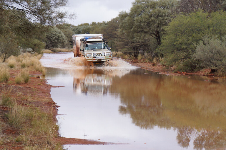
From Bamboo Springs we cruise north on a near deserted road to Ashburton Downs homestead only to find the river there to be in flood and flowing across the wide causeway.
Walking the crossing to make sure the concrete is still in one piece, we come across a tangle of wire and star pickets, remains of a fence washed away in the flood. We clear the route but with the sun sinking to the horizon we decide to wait overnight and let the river level drop even more.
In the morning the Ashburton is an easy crossing and with little to slow us we head north, taking to the bitumen for a short while before ducking into the Cane River Conservation Park. Once again there is little info available on this large park of around 186,000ha which straddles the Cane River, south east of Onslow. Rolling stony hills and gravelly sandy plains, both covered in spinifex and dotted with scrub, make up the majority of the park. The property was once part of a much bigger Peedamulla station with Cane River being established in its own right in 1949. The homestead, the ruins of which can be seen today, was built seven years later. After a number of owners, the property was taken over by the DPaW in 1996.
Cane River homestead
Few maps show any roads into this park but an old shire road leaves the Paraburdoo Road about 31km from the Nanutarra Roadhouse and cuts right through the park meeting with the NW Coastal Highway near the junction of the Onslow Road. A few kilometres east of the coastal highway a track (junction at GPS 22°10’32.4”S 115°33’48.8”E), heads north and crosses the Cane River at a wide sandy crossing a few kilometres south of the ruins of the Cane River homestead.
There is a trickle of water between long shallow waterholes in the river bed when we arrive and prop for a couple of nights to explore the area. The recent rain has also triggered an explosion of flowers and we find many carpets of Sturt Desert Pea, surely one of the most spectacular flowers of our semi arid and desert country.
3-Mile Pool
However, rain is often a double-edged sword in these areas. The effects of the recent rain prevent us from heading to Old Onslow and the mouth of the Ashburton, while at the popular camps along the river at 3-Mile Pool, people are unable to move for a couple of weeks, with no one allowed in or out!
Stymied by the flood waters we head south, crossing the Ashburton on the blacktop and turning onto a little used station track to follow the course of the river east. With permission from the land owners we find our way to our isolated creek-side camp and spend a few days exploring the gorge and the caves in the nearby cliffs, but our efforts to follow the river further upstream are in vain. Time and the amount of water washing around the country side have foiled us, but we’ll be back to explore and enjoy this vast area between these two great rivers once more.
Please enable JavaScript to view the comments powered by Disqus.
COMMENTS