Explore VIC
Gallery1
Not much more than an hour north of Melbourne, via Bacchus Marsh, this 201.8km² state park is popular with off-road tourers, campers, anglers, rock-climbers and bushwalkers.
The Lerderderg River cuts a path through the main section of the park, with the gorge it has created up to 300m deep in places, showcasing just how powerful flowing water is over many years. The terrain is rugged in parts, with heavily forested areas that contain a mix of ironbark, dry stringybark and peppermint-gum trees and, as well as the Lerderderg River, there are many other smaller waterways throughout the park. As the park is close to the city it can get crowded on weekends, but it is still worth checking out. Of course, if you can visit mid-week, it’s quieter.
The majority of 4x4-only tracks are in the park’s main northern section (where the park boundary abuts Wombat State Forest, another great off-roading destination) and the eastern side (note: some tracks in the park are closed from mid-June to October, including Ambler Lane Track, XL Track, Lloyd Track and West No. 5 Track. For all track closures, see parks.vic.gov.au).
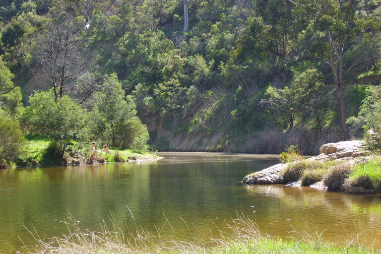
When open, these tracks make for great off-roading – steep, muddy when wet, with plenty of water crossings – and you can use them to link the park’s major roads and scenic highlights; O’Briens Road offers some brilliant views of the gorge itself. For this adventure, we’d recommend accessing the park via its southern entry point of Lerderderg Gorge Road, not far out of Bacchus Marsh. This also means you can stop for lunch/morning tea at Mackenzies Flat Picnic Area, which has excellent facilities (toilets, picnic tables and electric barbecues). The picnic area is next to the Lerderderg River, so bring your swimmers for a dip in warmer weather. Be warned, however, this location is (understandably) hugely popular with day-visitors and can get crowded.
Look at a map and you will also see a separate part of the park – dubbed Pyrete Range Lerderderg State Park – with it and the main part divided by the Bacchus Marsh-Gisborne Road. This area is strictly no-vehicle access, but if you’re a bushwalker or mountain biker you can walk/ride the access trails here; however, camping is not allowed.
MOREExplore VIC
In the western part of the park, vehicle-based camping can be found at O’Briens Crossing (it’s a small site next to the river with barbecue pits and a toilet nearby). You’ll need to either bring your own water or treat what you draw from the river. From this campground there are a number of bushwalks easily accessed, ranging in length from a one-hour stroll down to Grahams Dam (a top swimming spot); the six-hour medium-grade East Walk that follows the river before a climb up Cowans Track and then back again via the road itself; and then Short Cut Track.
For the super-keen, there’s an overnight trek that follows the gorge and river from O’Briens down to Mackenzies Flat. Camping at O’Briens Crossing you will also (hopefully) spot some of the native fauna that reside in the park: swamp wallabies, echidna, powerful owls and greater gliders are some examples. For anglers, it is worth an amble along the riverbanks to try your hand at catching the brown trout found in the river.
A more remote, 4x4-access-only campsite can be found at Amblers Crossing, accessed via Amblers Lane Track in the park’s northern section. This is a small campsite that offers an escape from the relative hustle and bustle of Mackenzies Flat and O’Briens Crossing, plus it is right next to a water crossing so ideal if you’re camping in summer and need to cool off. The walk to The Tunnel, a natural rock formation, can be accessed from camp. Amblers Lane Track also goes into Wombat State Forest if you’re keen for cross-border exploration; the state forest’s tracks offer everything from a laidback cruise to seriously challenging terrain. There is one other remote campsite near the northern state park/state forest boundary meeting point on the Upper Chadwick Track.
A night at Amblers Crossing is our tip, followed by a leisurely morning exploring this area before jumping in the rig and turning northwest toward the park boundary near the town of Blackwood (making sure you stop at Shaws Lake for another dip) and back to the bitumen. Alternatively, you could head east and wind in and out of the state park and Wombat State Forest, before finishing off your visit by tackling the steep, rutted Ratcliffe Track (check conditions first – don’t attempt this track after heavy rain) and then rejoining the bitumen at Bacchus Marsh-Gisborne Road. It may be small, but Lerderderg State Park promises a couple of days of big fun.
Want more Melbourne City 4x4 Escapes?
Please enable JavaScript to view the comments powered by Disqus.
COMMENTS