Explore VIC
Gallery2
THE TRACK dipped and climbed along the ridgeline, rising steeply to a trig point before descending in a rush to a saddle, where you could grab a breath before another long climb began.
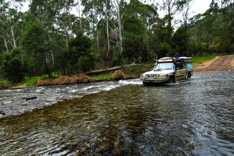
For most of the time the Cruiser coped easily in third low. The track was in pretty good condition, with a firm and even surface, though it was bloody steep and narrow in places. Perhaps not as exposed or dramatic as Billy Goat Bluff or the Blue Rag Range tracks, but still challenging, with impressive views all around.
Only on the short scramble to the crest of Mt Selwyn did I slap the gearbox into second and floor the accelerator. The V8 responded, the Cooper STT Pros scrabbled for grip on the pot-holed, shaly rock, and the suspension bucked and jostled the wagon to the top.
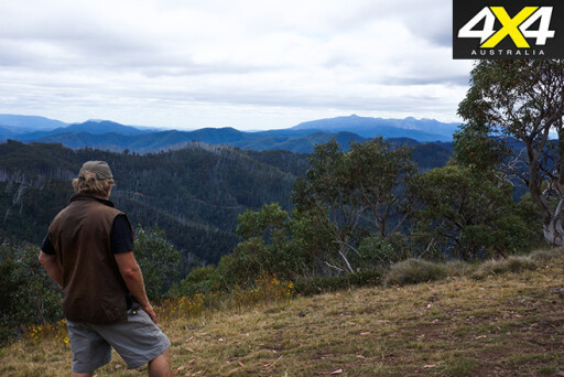 The view from the crest of Mt Selwyn was dazzling. To the north the indented skyline of The Horn on the plateau of Mt Buffalo could be seen, while to the west were the jagged outlines of Mt Cobbler and Mt Speculation. To the south Mt Howitt stood proud, while to the east were the high snow plains of Hotham Heights and Falls Creek. In between and all around the ridges, peaks and valleys of the Australian Alps and the Victorian High Country filled the scene from horizon to horizon. It was a grand view.
We had been coming to this area of north-east Victoria for more years than I care to recount, but we had never taken the Yarrabuck Track that joins the Buffalo Range Track along the high ridge that borders the Buckland Valley to the west. That was a crazy oversight.
On this trip we were mapping the next edition of Hema Maps’ The High Country Atlas & Guide, so we were looking for new 4WD routes that hadn’t been ‘discovered’ and would inspire travellers to leave home, get away from the norm and breathe some clear mountain air. On this route we found all that in spades.
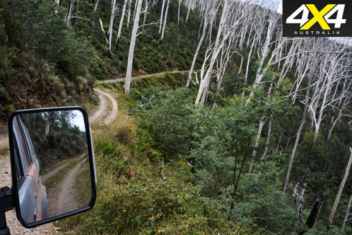 From Mt Selwyn, our route dropped down the narrow Great Divide Track through a forest of dead giants that tower overhead until Selwyn Creek Road meets the Twins Jeep Track. From here you can follow the high ridges and cut across to Mt Murray and Mt St Bernard on the Great Alpine Road, just below the glitz and glamour of Mt Hotham Resort.
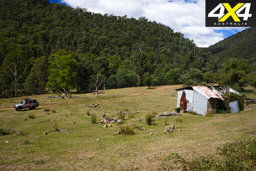
We opted for less fancy fare and headed north, winding downhill and meeting with the east branch of the Buckland River before arriving at the large clearing of Beveridges Station.
The station is named after the first pioneers here, the Beveridge brothers. In the mid-1800s the brothers had some large parcels of land in the High Country, including this long delightful clearing beside the river. Today, a section of the cleared land is in the Alpine National Park, while downstream the area is still private grazing land and is marked by the ruins of an old shack that’s slowly succumbing to the elements.
 The Buckland Valley is more famous for being one of the richest alluvial goldfields in Victoria. The fields were discovered in the winter of 1853 when a small party of men led by Henry Pardoe obtained 360oz of gold in just a couple of days. By spring of that year, 3000 diggers were in the valley, with another 3000 arriving by January 1854.
However, disaster soon struck as typhoid disease swept through the rough camps and the Buckland gained the reputation of having the highest mortality rate of any Victorian goldfield. It was said by those who were there that the valley was so thickly dotted with graves the river seemed to wind through a churchyard.
In July 1857 the infamous Buckland riots occurred. European diggers violently attacked and expelled the Chinese gold-seekers who had arrived there in the thousands. Many were killed before the police, led by Superintendent Robert O’Hara Burke, arrived from Beechworth. Burke was to later find lasting fame by dying on the banks of a distant Cooper Creek, leading what became known as the Burke and Wills expedition.
 By the early 1900s hydraulic sluicing and bucket dredges had turned the worn and torn river flats along the valley into seemingly one big gravel pit. The dredges worked the complete length of the river, including both branches of the Buckland upstream from Buckland Junction. Meanwhile on the steep ridges, hard rock miners sorted the gold-bearing quartz reefs, with dozens of mines, including the Band of Hope, Comet, and the Rip and Tear, extracting the wealth that lay beneath the rocky soil.
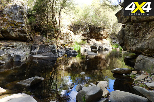
Today the valley is quiet, peaceful and surprisingly green, with grassy flats between the dense stands of native forest. All the effort and toil of the past can still be seen, though. There are piles of rocks along the river, there are the low cliffs formed by the hydraulic sluices, and there are channels and races that cut across the landscape.
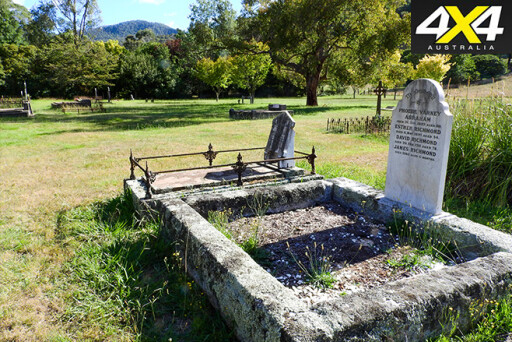 At the old cemetery beside the main road, poignant headstones testify to the tough past. While nearby is a monument to the Chinese who died during and after the riots. Little remains of the machinery that helped work these mines, apart from some scattered and torn metal fragments of boilers and furnaces. Flecks of gold can still be recovered from the river, and occasionally a rich pocket of alluvium missed by those early miners can be discovered by the lucky fossicker.
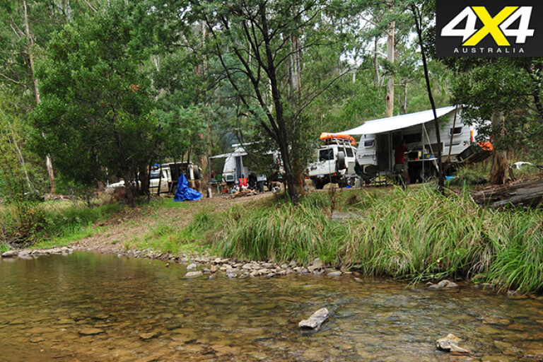
Most people come to the Buckland these days for the tranquillity of the valley, as well as the chance of catching trout, finding a fleck of gold, hunting a deer, or enjoying a 4WD track. We enjoyed our survey trip so much we went back again a few weeks later with friends, to camp on the Buckland and to drive Buffalo Range once more. It was even better the second time around!
2
TRAVEL PLANNER
WHERE
Buckland Valley – 380km north of Melbourne.
WHEN TO GO
Spring to autumn.
DRIVING CONDITIONS
Most tracks are easy to moderate.
CAMPING
Numerous sites; most have fireplaces, but just one has a toilet.
PERMITS/RESTRICTIONS
No permits required. Some tracks (not the main access to valley) are subject to seasonal closure.
FACILITIES
Normal travel facilities, campsites and accommodation at nearby Porepunkah, Myrtleford and Bright.
MORE INFO
Bright Victoria website
Please enable JavaScript to view the comments powered by Disqus.
COMMENTS