Explore VIC
Gallery5
Off-road exploration, remote river canoeing, and plenty of hiking are all on offer when you visit Victoria’s south-west coast.
Victoria’s far south-west corner hides two of the prettiest national parks in the region. Lower Glenelg National Park is dominated by the Glenelg River, which stretches from Dartmoor in the north to Nelson near the Vic/SA border on Discovery Bay. The Glenelg is regarded as one of in Australia’s best flatwater canoe trips. Here, visitors can admire an abundance of wildlife, including platypuses, ducks, koalas, wallabies, wombats, emus and kingfishers. Then there’s neighbouring Cobboboonee NP, offering recreational activities such as bushwalking, horse-riding and vehicle-based touring through eucalypt forests. Our adventure kicked off from Cobboboonee NP. We entered from the north, turning off the Princes Highway at T and W Road (37 59.942’S, 141 26.267’E) between Heywood and Mt Gambier. The turn wasn’t particularly well signposted and if we weren’t following our progress on the GPS we would have missed it. The unsealed road is the main passage through the park and, although well-formed, it’s single lane all the way, so scan ahead for oncoming traffic. Initially, it passes pastoral and cleared land before entering the forest.
The map in the Cobboboonee National Park Visitors Guide is the best track network resource. You can print it online or grab one of these guides from any of the tourism centres in the area. The popular Rose, Wine and Wood tour (90km) is a highlight, stretching from Portland to Heywood via a forest track. You can tackle this from either direction, although most of the signs favour a south-north run; travelling north-south from Heywood may result in some geographically challenging moments if you’re trying to wing it without the map. In addition to the beautiful forest drive, the touring route passes several local wineries, as well as Treloar Roses, Australia’s leading supplier of bush roses. Acres of rose gardens provide ample opportunity for you to get out and, er, smell the roses.
Portland is a bustling seaside town. There’s a big Visitor Information Centre down near the water that is well signed from the main road, with all the information you will need on the neighbouring national parks and services. Fishing is also popular and catches of snapper, flathead, whiting, trevally, salmon and sweep are likely. Sharks, such as blue, mako, thresher, bronze whaler, school and gummies, can be targeted in Portland Bay during the mating season from October to December.
Cape Nelson Lighthouse is worth a look, even just to drive past the massive rotors of the neighbouring wind farm, or to cast an eye out to sea in the hope of spotting a passing whale. Lighthouse tours are available and you can grab a bite to eat at the cafe or even stay a night at the luxurious restored Light Keepers’ cottages.
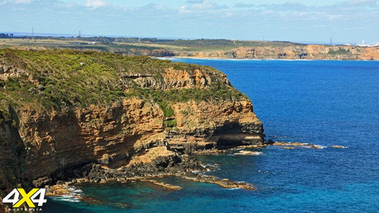
Not far away at Cape Bridgewater, the Discovery Bay Coastal Park arches its way to beyond Nelson. There are few opportunities to lock the hubs in around these parts, the exception being the Portland Dune Buggy Club. Accessed from the Swan Lake campground, the area contains 1800ha of tall, bare sand dunes. The club has been working with authorities since 1969 and now manages the area. Bylaws prevent driving on the beach or vegetated dunes. A four-day temporary membership ($50) gets you onto the property, which includes camping at Swan Lake.
Back in the national park, there’s the 250km Great South West Walk. This walk is broken up into four sections, covering Cobboboonee Forest, the Glenelg River gorge, Discovery Bay beach and the Capes and Bays. Check the walk’s website – see Travel Planner, page 120 for all the details.
There are a few other intersecting walks. The Heath Nature Walk, on Cobboboonee Road, has plenty of wildflowers on display during the season and interesting animal diggings along the way; so much so, you need watch your foot placement to avoid rolling an ankle. Apparently, most of the diggings are from potoroos, which forage around in the sandy tracks for food.
While travelling through the park, keep an eye peeled for swamp wallabies. It is easy to pick up speed on the transport legs running back to camp at the end of the day and these dark-furred critters blend very well into the charred landscape. Vehicle-based camps are restricted to the Jackass Fern Gully Picnic and Camping Area in the north and Surry Ridge Picnic Area to the south. Each has pit toilet facilities, picnic tables and fireplaces – and best of all, everything is new. We were the only ones camped at the former. The ground wasn’t as flat as it could have been, but easily remedied with levelling planks and more than compensated for by the pristine surroundings. The forest environment is a soothing place to be, sitting around listening to the birds and other animals foraging in the undergrowth.
The camping area at Surry Ridge Picnic Area offers a more open layout and a predominantly flat base, which suits the grey nomad crowd a little better; evidenced by the three large vans during our visit. Like other campgrounds in the area, ant nests can be a problem, so be wary of them relative to where you make camp.
North of the Jackass camping area, Inkpot Road joins the neighbouring Lower Glenelg NP towards the eastern perimeter. The Glenelg River is the hero attraction, with camps scattered along its banks. It’s aboaties’ paradise and popular for fishing, water skiing, pleasure cruising and the aforementioned paddle craft, in addition to those seeking just to prop and enjoy the surroundings. We camped at Pritchards, a large camp with boat launching facilities near the eastern boundary. Pritchards is one of the few campgrounds recommended for vans, with sites 11-20 cut into the bank, and many offering an elevated view of the river (some also have shade). The other 10 sites are more open. We had a school camp not far from us for a few days as part of a canoe skills course. If you are looking for a wilderness escape, chances are you’ll be a lot better off at one of the smaller, intimate sites.
The Glenelg River Canoe Trail provides seven additional camps, with most accessible only by water. Like the other campsites, these must be booked online, but are only available for one night, such is the popularity of the area for canoeing. Toilets, fire pits, picnic tables and rain water are available at each camp. Authorities warn downstream travellers of the impact of the tides and wind as the trail nears Nelson. The upper reaches beyond Pines Landing can also be impacted by submerged obstacles and shallow sections. If you don’t have your own canoe, you can hire one from Nelson, leave your car at the hire shop and organise a drop off at your designated location, leaving you to paddle downstream. Adventures range from half a day to five days, camping overnight in the specialist canoe camps. Alternatively, you can hire a fishing boat, party pontoon or even a houseboat.
Glenelg Drive is a couple of kilometres west from the turn-off to Pritchards camp. This unsealed track follows the river west, providing access to the remaining southern riverside campsites. In contrast to Pritchards, Battersby is a more intimate camp, a few kilometres downstream with two allocated sites. The Forest Camp was another delightful smaller camp with a slightly elevated position and four sites.
All vehicle-based campsites include a toilet, picnic table and fire pit to help manage the masses. The Sapling Creek Picnic Area provides another boat launching ramp and jetty on a bend in the river. The track here eventually regresses to deep soft sand, mandating reduced tyre pressures and four-wheel drive to maintain forward progress. The Gorge Walk (10km) steps off near the intersection of the North Nelson Track, offering views of the towering limestone cliffs. Alternatively, take a boat cruise from Nelson to admire the cliffs from a different perspective. Camping is also available on the northern side of the river, accessed via Wanwin Road.
If the comforts of hot showers and flushing toilets are too great, the Princess Margaret Rose Caves north of Nelson offer an alternative, with a pretty camp ground in a bush setting. Although set back from the river, the powered and unpowered sites offer at least some shade, picnic tables and fire pits. There are also basic cabins that sleep four in twin bunks, with limited cooking facilities and an external fire pit.
The guided caves tour is informative and scenic, revealing formations created from the slow drip of rainwater through the limestone over thousands of years. There are plenty of other good touring options in the area. A volcanic landscape stretches across western Victoria into South Australia. Mount Eccles NP and the surrounding Mt Napier State Park in Victoria provide evidence of a volcanic past, with dormant volcanoes and a landscape scarred by past lava flows. The crater lake of Lake Surprise, the Tumuli lava blisters, Byaduk Caves and pioneering stone walls provide a hint of the area’s history. The dramatic landscape continues across the border in Mt Gambier, with crater lakes and sinkholes; the Blue Lakes and Umpherston sinkhole being the most popular.
TRAVEL PLANNER
Where: Cobboboonee and Lower Glenelg national parks are in south-western Victoria, between Portland and Mt Gambier, 400km west of Melbourne or 500km east of Adelaide.
Camping: Cobboboonee National Park: pit toilets, fire pits, picnic tables. No fees.
Lower Glenelg National Park: pit toilets, fire pits, picnic tables. $16.40-$21.20 per site/night, max six persons.
Glenelg River Canoe Trail: pit toilets, fire pits, picnic tables. $4.60 per person/night, max two persons/site.
Princess Margaret Rose Caves: hot showers, toilets, $21-25 per site/night, cabins $65-70/night, max four persons.
What to take
GPS, fishing rods, walking shoes, binoculars, canoe, firewood and drinking water.
Supplies: Nelson and Dartmoor will have basic supplies but Heywood, or in particular, Portland, will have all services and repairers.
Trip standard: Easy.
Maps and guides
Cobboboonee National Park Visitors Guide, Lower Glenelg National Park Visitors Guide, Glenelg River Guide www.parkweb.vic.gov.au
Contacts and information
Parks Victoria: 131963 www.parkweb.vic.gov.au
http://parkweb.vic.gov.au/visit/book-your-stay
Nelson Boat and Canoe Hire: 08 8738 4048
www.nelsonboatandcanoehire.com.au canoes from $65/day.
Princess Margaret Rose Caves & Campground: 08 8738 4171
www.princessmargaretrosecave.com, Cave tours $16 adult, $10 child, $37 family (2A,3C)
Portland Dune Buggy Club: 03 5529 2468
www.portlanddunebuggyclub.com.au
Great South West Walk: www.greatsouthwestwalk.com
Check the Parks Victoria website before travelling. At the time of writing, the fires from February 2013 had caused some tracks to close, mandating large detours if travelling through to neighbouring parks. Also check the CFA website for any fires currently burning or any planned burns.
Permits and access
A temporary membership is required to access the Portland Dune Buggy Club.
Please enable JavaScript to view the comments powered by Disqus.
COMMENTS