Explore SA
.jpg )
Gallery1
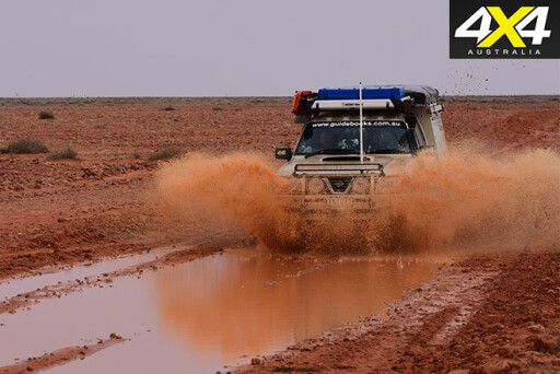
"Bugger," I thought as the Patrol ploughed to a halt in the thick, glutinous mud of the claypan.
Slipping out of the cab, my boots and I quickly became a few centimetres taller as the wet, clammy clay clung to everything. The front end of the Patrol was down, with the diff no doubt resting on the crust of mud. Meanwhile the tyres looked like slicks, caked in a thick coating of red-brown muck.
Luckily, the back end of the truck was just a short distance from terra firma, as all our momentum had been washed away in just a few metres of the fulvous-coloured, gummy earth.
 Still, we were bogged – really and truly bogged – in the middle of the Simpson Desert, late in the season, with not a traveller in sight, and we weren’t within UHF radio-calling range. Apart from the new owners at the Mount Dare Hotel, we hadn’t seen a vehicle or another person since leaving Oodnadatta three days earlier.
If travelling with another vehicle, such a bogging wouldn’t be a huge problem; with the dexterous use of a snatch strap, we’d be back out on dry, firm ground, ready to push on in just a few minutes. But on our own, as we were, this was a major undertaking and there was no way out other than to get the MaxTrax off the roof rack and the shovel down from its holder to do some serious digging and lifting.
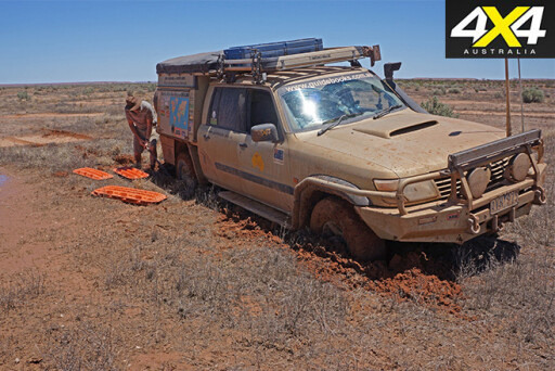 After an hour and four uses of the MaxTrax, we were back on hard ground, panting and sweating and covered in mud from head to foot. Then, back in the moving Patrol, we edged around the flooded-out country of the Spring Creek Delta, re-joining the main track near Freeth Junction.
While much of the main track east of Dalhousie Springs has been re-aligned in recent years to avoid the worst of the delta area, it seems not all of it has been bypassed. Later that afternoon, Purni Bore was an early but welcome stop that was made even better by the new shower that adorns the dune near the camping area. Mud-free, away from the delta and with the dunes still moist from the rains, the drive had been easy and we were looking forward to getting to the start of the Colson Track – our destination for the trip – the next day.
Our adventure had begun a few days earlier, when we’d left William Creek on the Oodnadatta Track rather hurriedly after being told rain was on its way. That night, we threw down our swags under a tin shack’s shelter and watched one of the most impressive thunder and lightning shows I’ve ever seen. Still, there wasn’t much rain in it and next morning we drove in to Oodnadatta, fuelled up and, with no roads officially closed, pushed on.
 North of Hamilton Station we began to run into more and more water across the road, but nothing that was too long, deep or intimidating. Still, I thought, if it stays like this, we’ll stop at Eringa Waterhole – a favoured campsite – and wait for the roads to dry out a little. However, by the time we got to Eringa, the surrounding country had received much less rain and the tracks were almost dusty (at least for a short time), and we pushed on – luckily, as it turned out.
We spent that evening at the Mt Dare Hotel, yarning to one of the new lessees, Tony, about his short time at the remote pub, which is an important service centre for the west of the Simpson Desert. Just as the sun was setting, the thunder and lightning began, followed by a torrential rainstorm that in 10 minutes dumped 18mm of rain on the property, followed by another more leisurely 7mm in the next hour. The campground was awash!
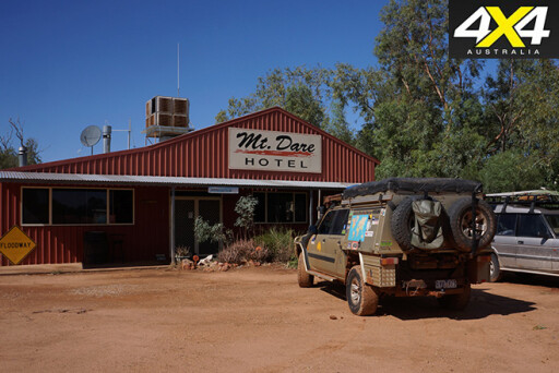 The next morning we checked the road report and rang a few of the surrounding station properties. Most had received a similar amount of rain but no roads in the immediate area or within the desert were closed, so we said our goodbyes and headed off. That foray didn’t last long. While we could have pushed through the long, deep stretches of water that had appeared on the tracks, we didn’t want to chop the tracks up too much (or get stuck somewhere). So we returned to Mt Dare, set up the swags and had a yarn, a beer and a meal at the bar.
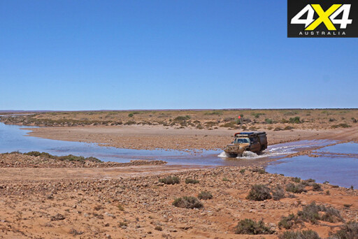
Our travels the next morning were a little more successful. While there was still water over the track in many places, it had dried back quite a lot and we easily ploughed through it. Where there was a side track, we simply dodged around the water. The last three kilometres into Dalhousie were the stickiest and slipperiest. We almost got stuck permanently in one section when the thick mud, much of it now clinging to the underside of the Patrol, stopped the transfer-box lever from selecting low range.
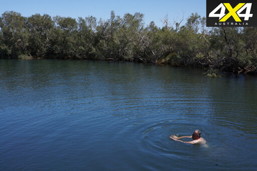
We sorted out the transfer selection at Dalhousie and had a swim in the spring to celebrate. My mate and I were the only two people at the oasis, a place usually popular with many travellers. Even the rangers had gone.
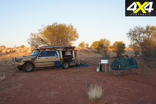
 A short time later we crossed the rarely flowing Spring Creek then, less than 20km on, while trying to dodge a wide and long section of water-filled, muddy delta country, we got ourselves into the previously detailed pickle (we got bogged). Still, camped at Purni that evening, with magical birdlife tweeting around us and firm sandhills in front of us, we saw that things were starting to look up.
Nearly four hours of relatively easy driving across the dunes the next morning saw us at the intersection with the Colson Track. The route east follows the French Line, the first west-east route cut across the desert in the early 1960s. Initially it is a pretty good, sandy track, but where the ‘Rig Road’ swings south about 30km east of Purni, the French Line becomes a snakier and sandier route with steeper dunes. I hadn’t been on this western section of the line for about 15 years, so it was good to be back, but I reckon it twists and turns, to get around the sand blows and wind-eroded dune crests, more than it used to
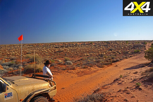 At the crossroads we stopped for a brew and looked north along the wheel marks that are the Colson Track. This north-south route was named after the first European to cross the Simpson Desert in 1936, Ted Colson. It was constructed, like most of these desert roads, in the early 1960s to give access from Alice Springs to the oil exploration leases that existed around the Northern Territory/South Australian border. The route north actually begins on the more southerly east-west track across the desert, the WAA Line at Lynnies Junction. It crosses the French Line, where we met it, at Colson Junction, 22km north of the WAA.
The Colson passes through some sensitive Aboriginal areas and for much of the past 20 years, getting a permit to traverse this track has been near impossible. But in October of 2015, I heard that the Central Land Council (CLC) was occasionally issuing permits, so I rang them and got told to apply online. Two weeks later I had a 'transit permit'. But while I thought I had a permit for the whole length of the route, I only had permission to head as far north from the border as Madigan's Camp 5. That had repercussions!
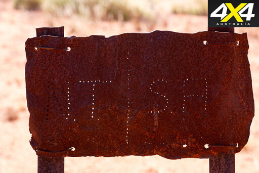 Unaware that we were heading into forbidden territory we cruised north, crossing the NT border 19km later at a small rusting sign before coming to the remains of the Colson Oil Well. Like most of the wells in the desert they never hit payable oil, but they have certainly left a legacy of tracks for us to use.
North of the old well, the track momentarily deteriorated to a sandy blaze twisting across the low dunes. It started to improve on its way north and we passed a number of old mining tracks heading east. A faint, sandy blaze on a western dune, about 140km north of the border, marked where most Madigan Line travellers cross from Madigan's Camp 1a (for cultural reasons, Traditional Owners ask people not to visit Madigan's Camp 2) to the Colson where they can access Madigan's Camp 5.
Cecil Madigan had crossed the desert through this area on his west-east crossing of the northern Simpson in 1939. It was after this trip that he named the Simpson Desert. Owen Correa, a desert tour operator, marked Madigan’s camps in 1994. It’s this route that today’s Madigan travellers follow, although access to Camps 3 and 4 is not permitted.
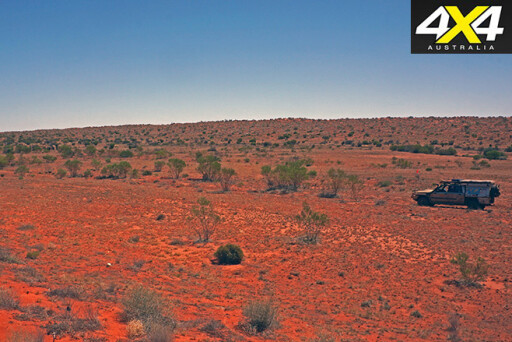 As we drove through this section, the country began to change and there were more shrubs and spindly trees to be seen. We’d passed through the driest section of the desert and had now come on to the ephemeral flood-out country of the farthest reaches of the Hale River and the small streams originating in the Allitra Tablelands. We could see just a few low, blue hills off to the far north-west.
As we got closer to Madigan’s Camp 5, there were signs of more recent mining exploration. Just north of a well-used but now abandoned crossroads we found the star picket and marker for Madigan’s camp, about 100 metres west of the main Colson Track.
Through here there were some pretty tempting spots where we could throw down our swags. If we had known we were now pushing into no-go territory we would have stopped, but blissfully unaware that we were doing anything wrong we pushed on, and the track quickly became little-used and badly eroded. The main access for the exploration company had been a newer track that had been pushed in from the west. We crossed an un-named sandy creek shaded by red gums and were again very tempted to stop. Still, we continued on, the day cooling after several hours of glaring heat.
 After what turned out to be a bloody good run in just eight hours’ driving, we stopped for the night in the shade of some tallish acacias some 230km north of French Line.
The next day, we passed out of the Aboriginal lands and through the eastern boundary of the 485,000ha Numery Station. The route again improved to a well-marked but little-used track. The dunes, which had hemmed us in at the start, were now no more than long sand humps with a wide, flat interdunal valley between them. Ahead of us, there was a proud dome of rock. Like a beacon, it drew us towards it.
Strangely, the peak hasn’t got a name on any map I’ve found. However, a nearby mountain – one of numerous crests of the low, rugged range just to the north – wears the moniker of Mt Aralka. When we got closer we stopped to admire the surrounding country and the peak, which is just off the track.
 The route then wound through the escarpment range country surrounding Mt Aralka, before heading directly east, skirting the northern bank of the Hale River and passing the sprawling estate of the Numery homestead. We stopped for a yarn with property’s caretakers, discovering that its new owners had removed most of its cattle, and the many camel skeletons we had seen were the result of a previous cull – all this to allow the country to regenerate.
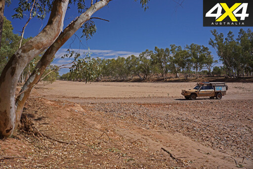
A short time later we crossed the wide sandy bed of the Hale River, its bank lined with a wide border of tall, thick and healthy red gums. Now it was just a good dirt road through delightful range country for 180km to the heart of Australia, Alice Springs... wow, it was good to be back.
But that's when the shit hit the proverbial fan! I found out I had gone where I shouldn't have, which meant a few phone calls and emails to sort that not-so-small issue out. The result: I won’t be doing it again!
Travel Planner
The Colson runs approximately 335km from the WAA Line to Numery Station. It is a remote, little-used track that gives access to the Madigan Line at Camp 5. While it actually continues north, it is in poor condition and access is not allowed by the Aboriginal Traditional Owners
Permits and Passes
You’re only permitted to travel the Colson Track north through the NT to Madigan's Camp 5, and for this you need a permit from the CLC (www.clc.org.au; (08) 8952 4566). You’re not allowed to go any farther north than Camp 5, but with a permit you may head east or west along the Madigan Line, as detailed in the map CLC supplies.
As part of any future permit for the Colson Track, it seems driving on any claypan off a marked track will be banned, as even when the claypans are dry, the resultant wheel marks are visible for many years.
A Desert Parks Pass from Environment SA is also required to access the Simpson Desert from the SA side.
Please enable JavaScript to view the comments powered by Disqus.
COMMENTS