Explore QLD
Gallery1
We’ve snuck south across the border (excuse the pun) for our final Brisbane weekend destination, and with good reason: the 31,680-hectare Border Ranges NP.
Located just 2.5 hours from Brisbane, is World Heritage-listed for its range of rare and endangered wildlife and flora, has one road (Lions Road) that takes visitors through landscapes ranging from Australia’s largest area of protected sub-tropical rainforest to truly mountainous alpine terrain, and offers brilliant camping.
Accessed from the north via the hamlet of Tamrookum (south of Beaudesert), Lions Road initially crosses the narrow ‘join’ of the park’s west and east sections. It is well-worth checking out the short track branching off the right-hand side just inside this narrow section, as it leads 200m down to a picnic area that offers views over the Border Loop railway line.
This was an engineering marvel in itself; crews of workers shovelled, dug and exploded their way through the mountains, building a tunnel to join the NSW and Queensland ends of the rail line together more than 80 years ago.
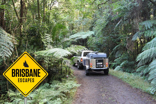 Once back on Lions Road, you continue south parallel to the western border of the eastern section of the park, before turning left onto Wiangaree Forest Road and entering the park proper, where you pay your vehicle/visitor registration fees (visit the NSW National Parks website for all fees and other info).
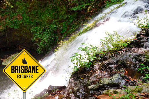
The popular Sheepstation Creek campground is just to the north of the entrance and provides access to a number of short bushwalks including the must-do Palm Forest Walk, a 2km loop along a long-disused bullock track to Brushbox Falls and then onto a large grove of the walk’s namesake bangalow palms. This campground’s sites are well away from each other and screened by natural vegetation, making it a great ‘base camp’ for maximising the weekend’s exploration of this park.
 Speaking of exploration – and for those super-keen bushwalkers – there is the much longer and more challenging Booyong Walking Track. This 9km one-way haul will see you finish at the park’s other campground – Forest Tops, a much smaller, walk-in camping area – so you’ll have to organise a pick-up at that end. Brindle Creek walk, from Forest Tops, is another longish loop that takes walkers through to Antarctic Beech Picnic Area, via some creek swimming spots.
Of course, if you cannot walk that far, you can still reach this beautiful picnic area – take the vehicular side track just east of Forest Tops. This is a one-way loop that leads to the picnic area.
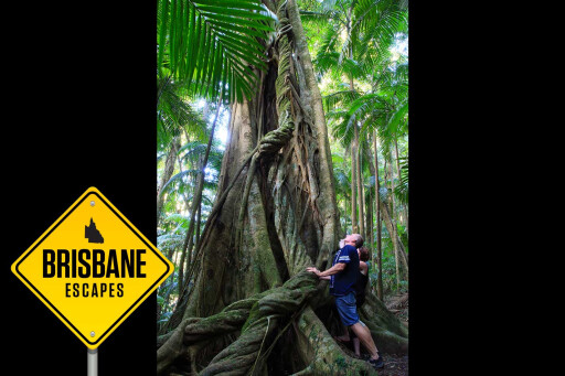
One last and much shorter walk worth your effort is the Red Cedar Loop, a 750-metre stroll to see one of the few – and massive – red cedar trees that escaped the timber industry. It is impressive.
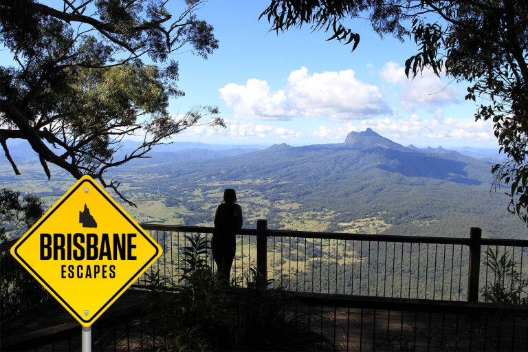
 The main track through the park – dubbed the Tweed Range Scenic Drive – is brilliant and joins Sheepstation Creek campground to Forest Tops before following the ever-higher escarpment as it winds eastward toward the aptly named Lookout Point. This is the first of a number of escarpment-based lookouts – others include The Pinnacle (reached via a short bushwalk) and, farther south, Blackbutt Lookout.
If you can, try and spend an early morning sunrise at The Pinnacle. This will give you what NSW National Parks rates as “the best views of the crater escarpment, Wollumbin-Mount Warning and the coast”. It sounds pretty epic to us.
MOREBrisbane Escapes
.jpg ) Continuing south and out of the park, don’t rush; a stopover at Bar Mountain Picnic Area will see you eating at the highest accessible area of the park, at 1140m. In fact, this picnic area is the same elevation as neighbouring Mt Warning’s summit. It is also a great place to check out some more ancient Antarctic beech trees (some of these are estimated to be more than 2000 years old) as well as its namesake mountain, just to the west.
Continuing south and out of the park, don’t rush; a stopover at Bar Mountain Picnic Area will see you eating at the highest accessible area of the park, at 1140m. In fact, this picnic area is the same elevation as neighbouring Mt Warning’s summit. It is also a great place to check out some more ancient Antarctic beech trees (some of these are estimated to be more than 2000 years old) as well as its namesake mountain, just to the west.
There’s also one last short bushwalk here – the 4km Bar Mountain Circuit – that drops down to the escarpment edge, with views over Collins Creek, Mount Barney and Mount Lindesay.
Between the huge diversity of landscapes – including the ancient rainforest and steep escarpment – and plethora of wildlife to view (quolls, koalas, boobooks, Albert’s lyrebirds, tawny frogmouths, numerous reptiles and the black land mullet – actually a skink) plus a couple of great campgrounds, Border Ranges NP makes for a true ‘escape’ into its Lost World, and it is all only a few hours’ drive from the city.
Please enable JavaScript to view the comments powered by Disqus.
COMMENTS