Explore NSW
Gallery1
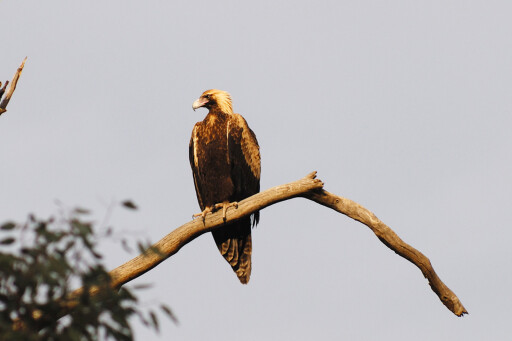
ROUNDING a bend on the track I braked to a sudden halt as the sight of a large wedge-tailed eagle perched on a dead tree less than 20m in front of me.
This article was first published in 4x4 Australia magazine's January 2011 issue.
The freshly killed remains of a large rabbit hung from its razor-sharp talons as the wedgie went through the motions of stripping the meat from the bone. Reaching over to the seat beside me for the binoculars, I slowly raised them to my eyes and began examining the feeding methods of this magnificent bird of prey.
Apparently unperturbed by my presence, the massive golden-brown raptor gorged itself for another 15 minutes before alighting from the branch with rabbit carcass and flying off towards the nearby hills.
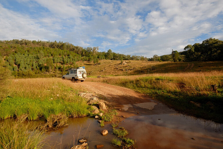
 Nangar National Park in central west NSW is one of those magic spots where you can be fairly sure of having close encounters with native wildlife during your stay. For me, the place was much nicer than I had originally expected after reading the park brochure before I went there.
Maybe that was partially due to lucky timing, as I visited Nangar a few weeks after recent heavy rain had transformed the normally dry brown landscape around the base of the hills into a carpet of green.
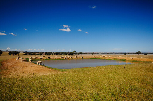
Situated between the wheat and sheep towns of Canowindra and Forbes about 340km west of Sydney, the park protects remnant stands of dense vegetation that was once common throughout this area before land clearing began.
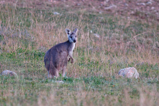
Nangar also supports an amazing array of wildlife including wallaroos, eastern grey kangaroos, swamp wallabies and red-necked wallabies. You may even be lucky enough to spot a koala as they have supposedly been sighted in the park, although I must admit after many hours of neck straining looking for those iconic tree dwelling marsupials I didn’t see one.
 Birdlife is also reasonably prolific in this rugged inland wilderness and includes brilliant songsters such as the Gilbert’s Whistler, colourful eastern rosellas and red-rump parrots and the swift flying peregrine falcon.
If you scan the hills you might even see an endangered glossy black cockatoo feeding on the large seeds of the black cypress tree. Nangar is at the western edge of the birds known range and provides an important refuge for the protection of this species.
Encounters with outback wildlife
The tiny town of Eugowra midway between Canowindra and Forbes is the starting point and the nearest place to stock up with food, fuel and water before heading out to the park. Situated on the banks of Mandagery Creek, Eugowra has population of around 700 and services grazing properties in the surrounding district.
First settled around 1860 by gold miners heading out to the Lachlan goldfields, this pretty little village has some lovely old buildings that are worth a look at including the courthouse and the Central Hotel.
 From Eugowra, head out of town along the road to Orange for 10km to the park turn-off, which is very well signed and hard to miss. About 3km along the way you will see a small roadside picnic area on the right near Escort Rock which was site of one of Australia’s most audacious robberies.
It was 1862 and gold fever had gripped the district with many miners making their fortunes in the fields. Their hard-earned wealth was normally put on specially escorted gold coaches for the fast dash to secure banks in bigger towns.
But bushrangers Ben Hall and Frank Gardiner and the other six men in their gang had got wind that a very large shipment of the precious metal was on its way and were waiting for the coach as it thundered along the road near Escort Rock.
The gang used two stolen bullock teams to block the road then opened fire on the helpless occupants of the coach when it was forced to stop. Two troopers in the police escort were wounded but managed to escape, allowing the gang to make off with all the loot.
 The gang got away with of 2,719 ounces of gold 3,700 pounds in cash, which at today’s gold price is more than $3 million. From the Nangar turn-off, it’s about 2.5km along a gravel road to the national park boundary then another 2km up to the information sign near the site of the old homestead.
Due to the scarcity of water and harsh nature of the terrain, Nangar was never totally cleared like other properties in the surrounding district and much of the original vegetation such as mugga ironbark and black cypress still covers a lot of the park.
Aboriginal people lived and hunted throughout the Nangar region for thousands of years and anthropologists are still finding stone implements and scar trees where bark was removed for shields and food containers.
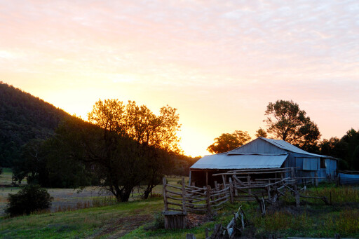
The first settlers to arrive in Nangar were the Cassey family who came there during the Great Depression in 1928. After constructing a house, small shearing shed and holding yards, this pioneering family used axes and crosscut saws to clear trees along the valleys and creek lines.
 A couple of dams were constructed to supply water for the livestock and a small orchard near the homestead, but the general harsh nature of the environment meant the Cassey’s were constantly battling the elements to try and make a living. Drought was a constant problem with the few small creeks on the property often running dry due to lack of rain.
Stock losses were also high due to sheep becoming lost in the thick bush or being taken by dingoes. By the mid 1940’s the family had had enough and moved off the block leaving the property to a succession of other owners until the NPWS purchased the land in 1994. With the addition of Nangar State Forest two years later the park now covers an area of 9196ha.
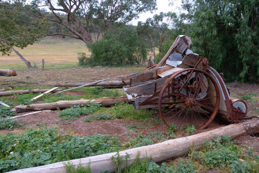
It’s worth spending an hour or so checking out the hand-hewn timber stockyards and the rusting remains of old vehicles and farm machinery that are scattered around near the old homestead site. Unfortunately some bonehead arsonists burnt the homestead down in September 2009 destroying an irreplaceable part of Australia’s history.
Once you leave the old homestead site the valley starts to become narrower as the track twists and turns for about 3.2km up to Terarra Creek Picnic and Camping Area. The country that you pass through is extremely picturesque with the track crossing Terarra Creek a number of times before it finally reaches the camping ground.
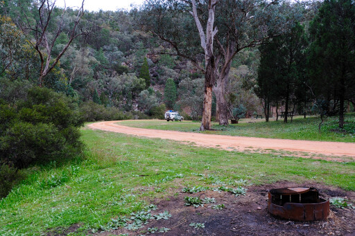 Set in a well grassed shaded area near Terarra Creek, the camping area would be an excellent place to spend a few days if you were looking for peace and quiet as it gets very few visitors.
If you were thinking about going for a swim, however, forget it, as the creek in this area is nothing more than a narrow stream about a metre wide meandering through dense stands of bottlebrush. Rugged, thickly vegetated hills covered with mugga ironbark and Black cypress rise up steeply from the creek making it an excellent place to scan the trees for birds and other wildlife.
The newly constructed camping ground has toilets, picnic tables and fireplaces. If you really feel the need for a small fire make sure that you bring in your own wood from outside the park since fallen timber provides shelter for many native animals.
It is essential that you are carrying adequate drinking water for the length of your stay as Terarra Creek is sometimes bone dry and there are no other water sources in the park. The weather at Nangar can often be extreme, with daily temperatures during the height of summer nudging 40 degrees while nights in mid winter can often drop to zero and below.
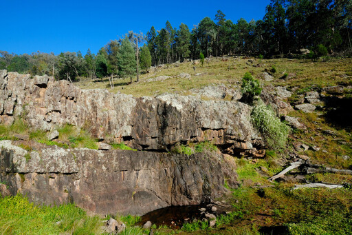 From the camping ground it’s only a short 10 minute drive up to Dripping Rock, one of the geological highlights in the park. This stunning rock wall, over which water streams during heavy rain, was formed over countless millions of years by the action of water slowly eroding away the rock.
Even in drier times there is usually a trickle of water dripping down the rock into a pool below. This lovely little waterhole is a magnet for kangaroos, wallaroos, birds and other surrounding wildlife.
Much of the area around Dripping Rock was cleared for grazing prior to the area being gazetted a national park, but nature is slowly coming back with the conical shapes of both white and black cypress trees along with tumbledown gum and red box covering the surrounding hills.
One distinctive looking tree with bright green leaves that dots the clearings around Dripping Rock is the kurrajong. Farmers left these trees as emergency food for stock and only cut them down in times of severe drought so they could be used as sheep fodder. There is a small picnic area with two tables near Dripping Rock where you can relax and take in the scenery.
The real four-wheel driving in Nangar National Park begins after you leave Dripping Rock and start heading up though the former state forest to Mount Nangar Lookout. The first 4km of the 10km long drive to the lookout is relatively tame as the narrow track weaves its way gently up trough dense stands of white and black cypress.
There is a dramatic change in the vegetation as the track becomes rougher and begins to climb steeply past large specimens of ironbark and grey box. Birdlife through here is prolific and if you stop your car and be quiet for a few minutes you will hear the melodious calls from noisy friar-birds and other nectar-eating birds feasting on the flowers of the surrounding eucalypts.
Just on 5.8km after leaving Dripping Rock you come to Y-junction in the track. The left-hand fork climbs steadily upwards for 4km to the lookout while the right-hand fork continues on towards the national park boundary 3.8km away.
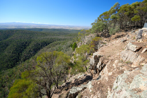 The panorama stretching before you from the lookout can be spellbinding with magnificent views along the jagged cliffs of the Nangar Range and the cleared grazing country to the north of the park. The lookout is an excellent place to spot birds of prey such as the wedge-tailed eagle and spotter harrier and if you are extremely lucky the endangered peregrine falcon.
Once you return to the Y junction it’s a relatively easy drive down to the gate at the park boundary—remember to close it, then another 5.7km on through state forest and cleared farming land to the road that runs between Long Pocket and Canowindra. Here you can either turn left and head back to Eugowra – about 34km, or go right to Canowindra about 15km away.
Please enable JavaScript to view the comments powered by Disqus.
COMMENTS