Explore NSW
Gallery23
GLEN Innes, located on the granite belt in northern NSW, is known for its wineries, Celtic culture and cool, crisp air. But did you know there is a great drive where you can explore several historical mines, spectacular scenery and check out some bushranger hide-outs, all with a great campsite tucked away?
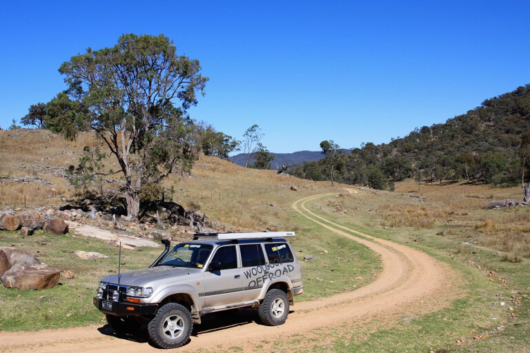
With very cool winters up on the tablelands and stifling summers, I decided to explore the region north-west of Glen Innes in early spring, hoping for a little colour and to miss the extreme temps that frequent this area. Glen Innes is a funky little town with boutique gift shop and some great bakeries, but it has most of the services that you would find in larger towns. There are several tourist drives that run around the town, but a great drive is tourist drive number 11, but with a twist.
After restocking supplies and fuel at Glen Innes, the road north-west towards Emmaville is a nice introduction to the area’s wonderful grazing land. It is a typical English-looking area, with tree-lined wind breaks lining the fences and sheep-filled paddocks with the odd boutique winery hidden here and there. The road to Emmaville is tar for its 40km length, but as it leaves the flat, fertile grazing land it will twist and weave its way over several ranges where you need to be on the lookout for feral goats and the odd ’roo.
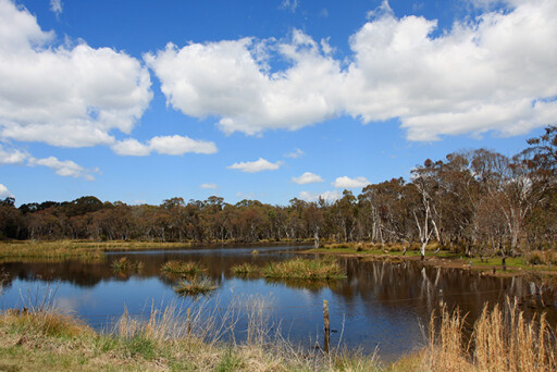
Closer to Emmaville you will come across the Y waterholes that grace both sides of the road. These waterholes are from the (now-closed) nearby Lead mine. Over time the water has become safe for birdlife to inhabit its waters and shore – from swans, ibis and a host of other birdlife, it was a nice change from the dry forests nearby.
Further down the road you come into the once booming town of Emmaville. Several places are worth checking out here: the mining museum (only open mid-week), the Emmaville lookout, and several old graveyards where some headstones date back to the late-1800s. A general store has limited fuel, if you really need to top-up.
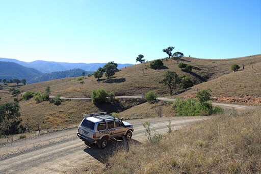
Following the tourist drive out of town for just 5km, a turn-off will appear to your left towards Torrington. This is where we leave the tourist drive and the adventure begins. The landscape out here is harsh and is scattered dry timber, while granite boulders dot the landscape without much undergrowth. It's pretty hard to miss, but after 6km the road narrows and passes through a gate and across a grid. It’s not signposted, but this is where you need to turn left to explore the old Ottery mine. The formed track will lead you to an open area where there is plenty of parking for several 4WDs. Adhering to the warning signs at the beginning of the track (no collecting rocks or going past the fences) it is an easy stroll into the old Arsenic mine and historic Ottery Tin mine site.
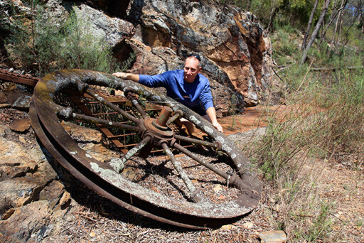
This historic tin mine was one of the first underground base metal deposits in the area and worked continuously from 1882 until 1905. During this period, it produced an estimated 2500 tonnes of tin concentrate and 2000 tonnes of white arsenic.
Several attempts to reopen the mine failed, and mining operations ceased in 1957. You can wander around freely, viewing old relics, such as mine buckets, an 80-metre-deep main shaft, the large flue, cooling chambers and furnaces. The white arsenic still leeching from the workings is one interesting sight. When the mine closed, it was left in an extremely damaged and dangerous state with open mine shafts and waste dumps – obviously posing a few health and safety risks.
The Department of Conservation and Land Management and Department of Mineral Resources carried out rehabilitation work in 1993. Thanks to these efforts, the site is now safe to visit, albeit from behind fences. This is a fun place to spend an hour or so, following the path around the mine, reading information boards and imagining what the toil was like here more than 100 years ago. We have to leave. Back through the gate, the tar winds for about 5km, then onto dirt that leads to an easy 30km drive towards Torrington.
You can’t help but notice the huge granite formations and cliffs that line the road. There are several bitumen sections over the steep ranges too – probably to prevent erosion occurring following the huge storms that rake this area from time to time. And to ease vehicle access it’s best to keep your travelling speed to a minimum. The roads here are granite-based, which means they can be very slippery due to the small ball-bearing type coverage on the surface. Turning your lights on for added safety is a good idea.
On the outskirts of Torrington, watch for the signposted Dutchmans Road on the left – this leads to Dutchmans camping and barbecue area. While ideal for setting up a tent or two, Dutchmans is really designed for a stopover rather than an extended stay. There are several pit toilets here as well as a great shelter if the weather turns nasty. It’s a pleasant area to kick back for a barbecue although a greater reason is to follow a short walking track to what was once a hide-out of the infamous 19th century bushranger, Frederick Ward (aka Captain Thunderbolt).
Thunderbolt was known to have roamed the area from Uralla in the south to Tenterfield in the north. A medium level of fitness is necessary for the 1km walk along the well-maintained track from the picnic area into the boulder area. This path leads to steps that wind their way around rocks and disappear into chasms between boulders that are as large as houses.
As you sneak between the rocks, it’s easy to see why bushrangers chose this area – it would have been a great spot to hide and use a higher peak from which to spy any approaching authorities. The walk passes through several dark sections between the rocks and eventually ends at a steel ladder. This 10-metre ladder is almost vertical and allows you to stand safely on a platform that provides 360-degree views. While the steep ladder might pose a worry for some, the views from the top are definitely well-worth the small fear factor that may come with the climb to get there.
Head back into the near-deserted town of Torrington, and you’ll find there’s only a handful of houses still occupied. In the 1920s, Torrington and the surrounding areas attracted a lot of mining activity; about 600 miners lived there at its peak. In that period, Torrington was a more lively place and provided facilities such as five general stores, two churches, a butcher, baker, courthouse, police station, post office and a hotel. These days, there are no such services. Surprisingly, however, there is limited mobile phone reception.
After leaving Torrington via Silent Grove Road, it’s a 15-minute drive to a great campground. As you enter Torrington State Conservation Area, a sign points towards Blatherarm campgrounds, 2km away. This spot has great facilities; each camp area has its own pit toilet and tables while a water tank is also available, offering unfiltered water for washing up or maybe even a quick scrub.
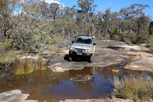
There are three camping areas here, aptly named ‘one’, ‘two’ and ‘three’. The first two have easy access but number three is across a creek, meaning you’ll need a 4x4, especially if towing a camper-trailer. The creek doesn’t contain a strong flow but, with a bit of traffic, it can be a bit rough.
No bins are provided so you’ll need to take all rubbish with you to keep the vermin away and the camp areas clean. An information board details interesting local history and wildlife and provides an insight into the area’s fossicking. If you’re lucky, you may stumble across gems, minerals or crystals in the dedicated fossicking site. Make sure you pay camping fees via the honesty system.
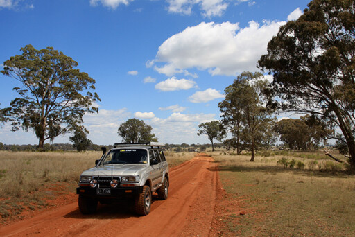
Leaving camp is as simple as heading back to the turn-off for a right-hand turn onto Silent Creek Road, where there’s 10km of granite cliffs and some interesting grunge sculptures along the roadside – it’s an eerie feeling as they watch you trundle towards your next destination.
Soon the landscape starts to open up, giving way to sheep and cattle stations where several mountain peaks and ranges in front of you rise to 1100m. The roads are narrow and sometimes faint as they twist towards Mole River. With the steep terrain, Mole River can at times suffer serious flooding – check out the amount of debris high in the trees and the curved tree trunks from recent deluges.
A further 3km along, two options appear: continue straight on to the Bruxner Highway, or turn right onto Upper Mole River Road. I choose the latter. This road passes more farms as you wind your way around granite tors and over easy creek causeways. And, the awesome backdrop of views towards the ranges means you won’t tire of the scenery.
Continuing through Gunya Station, there are more amazing granite outcrops, and it’s still hard to believe we’re 1000m above sea level. In winter, it can receive a covering of snow, so be prepared. In spring, though, it seems everything blooms out here with the odd prickly pear cactus and grass trees scattered among the rocks.
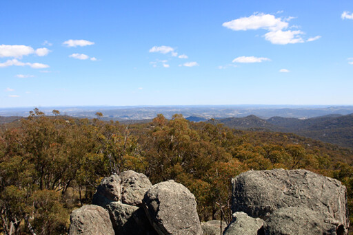
One last surprise awaits before we return to bitumen – a turn up to 1300m Mt Mackenzie affords stunning views over the Tenterfield area. It’s a great way to end a drive on the Granite Belt.
Please enable JavaScript to view the comments powered by Disqus.
COMMENTS