Explore
Gallery1
The sound of thunder crashed around us, echoing off the great cliffs of Fiftymile Mountain to our south and the natural rock amphitheatre of Dance Hall Rock behind us. Lightening flashed in a coruscation of blinding light and pulsating natural power as the leading edge of the thunderstorm rolled over the cliffs and rocky hills around us.
This article was originally published in the October 2014 issue of 4x4 Australia.
A splattering of raindrops followed, but the storm was more a light and sound show than a downpour. The few drops that did fall hardly unsettled the dust and only occasionally gathered in small pools on the sea of rock that surrounded us.
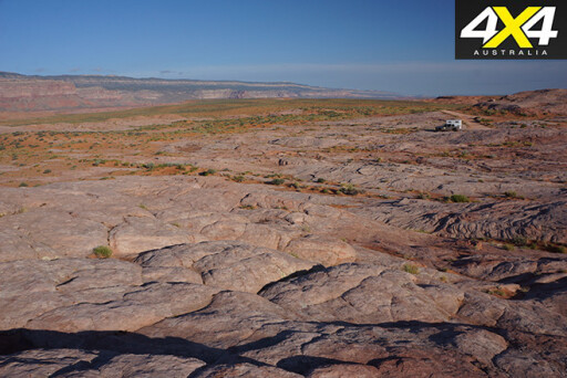
The rocks that swept away from us in all directions were ‘petrified dunes’ – once mobile sand dunes that have fused together over the years, but are now even more impressive in their harsh starkness. The four-wheel drive trail we were following dipped and climbed, curled and wandered among these low rock swells, the waves of rock becoming more pronounced and dominant the further we progressed.
 We were following in the footsteps of one of the most incredible settlement endeavours of America’s wild west. In the late 1870s, a group of Mormon pioneers set off to establish a community in the south-east of Utah. Their train of 80-odd wagons, 250 people and hundreds of livestock blazed the trail east from the small community of Escalante – when they came to the 600-metre sheer cliffs that bordered the Colorado River, in an area now called Glen Canyon, they simply pushed on.
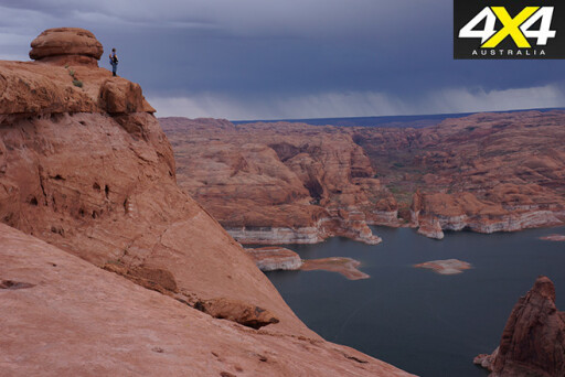
The group discovered a crack in the defile. Here they widened and suspended a road out from its edge in order to lower their wagons, livestock and people down the scary slope – this hole is now known as: ‘Hole in the Rock’. Once at the bottom, they built a ferry to get across the raging river. Then true hardship began as they tried to find a route up the other side. Talk about pioneer grit and fortitude – backed up by a big dose of religious fervour, no doubt.
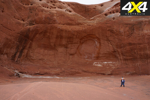
Still, until you stand on the edge of that high cliff at Hole in the Rock and look down to the waters – what was the Colorado River, and is now the backwaters of the man-made Lake Powell – the full enormity of what they did is impossible to comprehend. Most people are in complete and utter awe as to what the pioneers achieved and that is reflected in the visitors’ book that is found nearby – unbelievable, crazy, stupendous, stupid, awesome and terrifying were just some of the words listed.
 We wandered the cliff edge and climbed a short distance down the defile, shaking our heads in wonderment. Then, with nobody around, we set up camp nearby, our surrounds and view identical to what those early, hardy and resourceful pioneers had experienced.
Our travels in the south-west of America started a few weeks previously when we bought a second-hand Dodge Ram, fitted it with a Four Wheel Camper slide-on and headed for the remote parts of this extremely populated country.
In a country roughly the same size as Australia but with a population of more than 300 million it’s a little harder to find remoteness, but it’s still possible.
 Another camping spot that is more famous and on everyone’s bucket list is the Grand Canyon. This incredible place sees more than four and half million visitors each year, and while the popular spots on the South Rim are crowded much of the time, the North Rim is less congested.
If you head east or west from Bridle Veil Lodge, at the heart of the North Rim, you will end up on a series of forest trails that take you to the very lip of the canyon. Here, you can find a camping spot all to yourself.
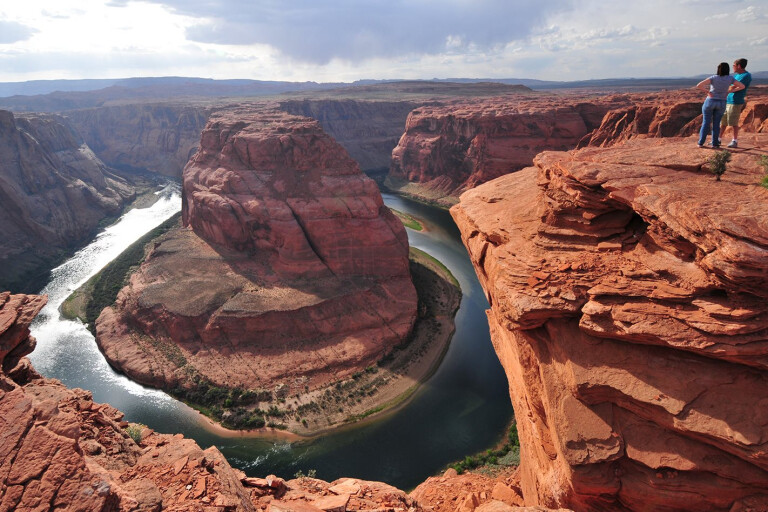
From the North Rim, we headed to Page where the mighty Colorado River has carved another canyon. Here, amongst an incredible range of vistas, there’s Horseshoe Bend and Antelope Canyon, the latter only spoilt by the number of people that wander through it.
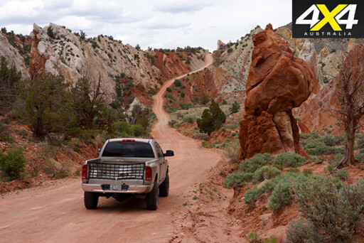
 From Page, we travelled west and crossed the border into (what has only recently become) our favourite state – Utah. Slipping off the blacktop, or ‘pavement’ as the Yanks call it, we entered the Grand Staircase-Escalante National Monument, a vast area that links many of the nation’s finest national parks and national recreational areas into a contiguous 1.4 million hectares of protected lands – that doesn’t include the huge areas of national forest that border these parks and reserves.
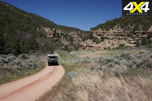
Our route through the national monument took us along the Cottonwood Canyon Trail, and some isolated camps along Cottonwood Creek, before coming to the rock formation of Grosvenor Arch and then the multi-hued Kodachrome Basin State Park.
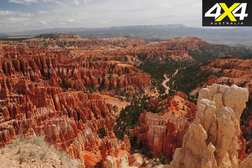
Nearby is the popular and impressive Bryce Canyon National Park. We took in some of the views and wandered the walking trails for a short distance, but it was way too crowded so we headed for the adjoining Dixie National Forest and picked up the Great Western Trail.
 This trail runs from the Mexico border in Arizona to the Canadian border in Montana and passes mainly through national forest and BLM (Bureau of Land Management) land. It would make a great trip and one we are planning to do in the future.
We camped in the heart of a small verdant meadow at an altitude of 2500 metres and just below a great white and red bluff dotted with pine and fir trees. A spring babbled from the ground just a few metres from our camp, and deer eyed us warily from the surrounding cover of trees and scrub. It was a magical spot.
The next day we rolled into the small hamlet of Escalante and then, after finding out about the endeavours of the early pioneers, we took to the Hole in the Rock track, which took us to the edge of the mighty Glen Canyon. Being of weaker mind and aptitude than the early Mormons, we turned our backs on this dead-end track and wound our way up into the higher country to the west of Escalante.
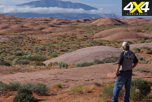
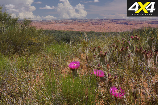
 One of the things I love about touring the west of America is the incredible variety of scenery you witness in just an hours’ drive. One minute we were in raw red rock country more akin to Australian desert country; next we were travelling through verdant pine covered mountains dotted with lakes cut by cool trickling streams.
Again we found a choice of campsites – the Forestry Service provided some fabulous camping areas while, with just a bit more flexibility and effort, we could find a more isolated spot on a pine fringed meadow, all to ourselves.
From our mountain top camp, we headed east along Hells Backbone and then onto the Burr Trail, left the Grand Staircase-Escalante National Monument and passed through the bottom section of the Capitol Reef National Park. We traversed an impressive series of switchbacks as the trail dropped over the edge of the Waterpocket Fold: the dominating 150-kilometre long feature of the national park.
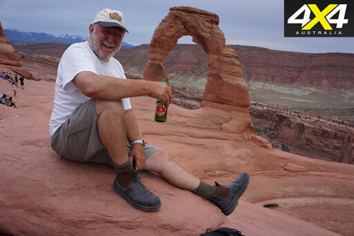
 For the next few days, we wandered the back roads, mainly through BLM land, leading to Moab, the mind-blowing vistas of Canyonlands National Park and the gravity defying rock formations of Arches National Park. We had been to both parks previously, and while there were always a few people around, these two parks and the surrounding country offer some of the best scenery, walks and four-wheel drive trails in all of the USA.
From Moab you can partake in a variety of adventures; hire a rock crawler or ATV, go rafting on the Colorado, climb or abseil some of the many sheer rock faces in the surrounding area, and horse ride or mountain bike on some of the high desert country trails from town.
After a somewhat disjointed wander through this four-wheel drive and adventure mecca we slipped into Colorado and headed into some fabulously rugged mountain country. Trouble was, while the main roads and highways were open, we were too early to travel the high mountain trails, which were still closed in early June due to snow.
 We contented ourselves wandering the more beaten paths as we made our way south into New Mexico. Where, once more, we took to rarely used trails in the wake of some of the wild west’s most famous characters; like Billy the Kid and Kit Carson. But that’s a story for another day.
TRAVEL PLANNER
GETTING THERE
Numerous airlines fly from Australia direct to Los Angeles in the USA and if you keep an eye on their websites you can get some great bargains.
 GETTING SOME WHEELS
Hire or buy? For hiring a fully setup RV start with Cruise America. There are plenty of others, including Tonto Trails who hire fully setup 4WD pick-ups with slide-on campers fitted or fully setup 4WD sportsmobile rigs.
If you are planning on touring for longer than a couple of months, buying a second hand rig is definitely a good choice. You’ll be surprised at what you can get for $10-20 grand.
BEST TIME
Spring (April-May) is good for touring the desert country of the SW and is less crowded. Summer comes late in a lot of the high country, so access can be restricted due to deep snow off the main roads and highways, so it’s best to be flexible.
 MORE INFO
All the parks, reserves and forests have great websites where you’ll find a heap of info. For the national parks/monuments, start at: www.nps.gov or for the national forests visit: www.fs.fed.us
In addition, the Bureau of Land Management (BLM) controls nearly 107 million hectares of land in the west and much of this is available for touring and recreation – see:
www.blm.gov
We always buy a state atlas of each new state we visit in the west – with their detail on tracks and reserves it will open up a new world to the US traveller. HEMA also does an excellent USA Road Atlas.
Please enable JavaScript to view the comments powered by Disqus.
COMMENTS