Explore
Gallery1
Whatever you want to call it, the jaunt to raise money for the Royal Flying Doctor Service and, for us, to satisfy the desire to travel to ‘every corner of the country’ was a very rough, but thoroughly enjoyable affair. However, this time around the remaining corners visited all come with some form of controversy caused by surveying mistakes.
This article was originally published in 4x4 Australia’s June 2011 issue
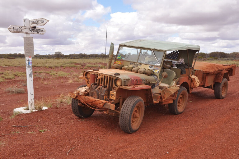
Roaring Meg, the 1943 WWII Jeep, was again accompanied by the shineysides [modern 4X4s] of the previous trip, with a couple more thrown in, as well as another 1942 WWII Jeep, so at least the modern-to-classic ratio was maintained.
.jpg ) It doesn’t matter how much research you undertake, it does not prepare you for the relentless corrugations that you will experience out there. Sections of the Anne Beadell Highway, most of the Connie Sue Highway that we travelled from Neale Junction north, and some of the abandoned section of the Gunbarrel Highway were abysmal, to say the least. The shineysides with current technology suspensions handled the conditions a bit better than our leaf springs of yesteryear.
It doesn’t matter how much research you undertake, it does not prepare you for the relentless corrugations that you will experience out there. Sections of the Anne Beadell Highway, most of the Connie Sue Highway that we travelled from Neale Junction north, and some of the abandoned section of the Gunbarrel Highway were abysmal, to say the least. The shineysides with current technology suspensions handled the conditions a bit better than our leaf springs of yesteryear.
Our primary group objective was to reach Surveyor Generals Corner, via some of Len Beadell’s famous highways. Some individuals within the group, however, simply wanted to find the best meat pie!
We set off in late August to travel quiet back roads due west from Sydney to Mungo National Park, then to access the corners of New South Wales, Victoria and South Australia via old mail routes along the north of the mighty Murray River. Due to border disputes and surveying errors, we have two corners here. Both are marked by simple signs on the river banks and are best accessed by boat from the old Customs House, via Renmark. You can hire a boat for the purpose – or a houseboat, for that matter – and camp in pleasant surroundings.
.jpg ) That scenic journey to the north of the river revealed a story of controversy on plaques attached to Todds Obelisk, which is located on the corrected position of the boundary between NSW and SA. It was determined in 1868 by Charles Todd, the SA Observer and Superintendant of Telegraphs. Briefly, this line of the 141st meridian should have continued south through Victoria, however Victoria would not recognise this and claimed the earlier determination, which is up to two miles (3.2km) further west. More than 40 years of SA’s legal challenges ended with a High Court decision in favour of the erroneous boundary. The dismissal of the 1914 appeal was the final nail. Hence, the border dogleg!
That scenic journey to the north of the river revealed a story of controversy on plaques attached to Todds Obelisk, which is located on the corrected position of the boundary between NSW and SA. It was determined in 1868 by Charles Todd, the SA Observer and Superintendant of Telegraphs. Briefly, this line of the 141st meridian should have continued south through Victoria, however Victoria would not recognise this and claimed the earlier determination, which is up to two miles (3.2km) further west. More than 40 years of SA’s legal challenges ended with a High Court decision in favour of the erroneous boundary. The dismissal of the 1914 appeal was the final nail. Hence, the border dogleg!
MORESimpson Desert
With that objective ticked off, we continued across the SA Riverland, (trying the pies, of course), and ran into some serious rain and storms at Port Augusta. So serious, in fact, that the Birdsville Races were cancelled, and the outback in general a little further to the north was closed for weeks. We eventually reached Coober Pedy after battling a severe headwind that knocked the consumption figures of all vehicles, but visited Roxby Downs, Andamooka and Woomera on the way. A rest day allowed some sightseeing and final preparations for the desert adventure. We received more track condition advice from the local towie. Allegedly, on a recent trip along the Anne Beadell, a mate of his had left his false teeth in the glove box and “they munched their way out!” As it’s not a declared road, there were no reports on the Anne Beadell, or closures either, so we set off as planned and accordingly heeded the advice and left the false teeth in.
.jpg ) A thunderstorm on the first night out ensured that we were not going to miss what many others experienced in other areas; water, water everywhere. It didn’t prove a problem, unless you deviated from the track. Lesson number one to all those who find themselves in a similar situation: Stick to the track!
A thunderstorm on the first night out ensured that we were not going to miss what many others experienced in other areas; water, water everywhere. It didn’t prove a problem, unless you deviated from the track. Lesson number one to all those who find themselves in a similar situation: Stick to the track!
For the first four days we did not see anyone. Not a soul. The track was described as good, but only between Emu and Vokes Hill Corner. The rest was corrugated and taking its toll on the 65-year-old, ex-army trailer with cracks appearing in its pressed-metal chassis. All is not lost out there, however, with plenty of spares available to salvage from the many other modern trailers abandoned by the roadside and, with a few bolts and the ever trusty cockies’ cotton, it was maintained in a serviceable condition.
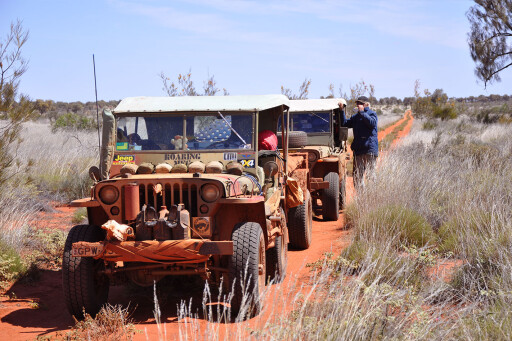
After seven long, slow days’ travel, we arrived at Ilkurlka in WA to a welcome shower and restock of fuel and supplies. But alas – no pies! The track west of here was described by a member of the party as ‘fabulous’, until we hit Neale Junction and headed north – to the tune of Mental as Anything, The corrugations were getting bigger. With the Jeeps in low-first at idle speed, it was possible to go for short walks, scratch the naval and smell the flowers, without even stopping before a small jog to catch up with the continuing Jeep. The same member amended his word of the day to ‘gruelling’.
.jpg ) We encountered another wet night and day, which ensured a very wet end to the Connie Sue, but a chance meeting with Connie Sue herself, and husband Mick, gave us the rare opportunity to let her know personally what we thought of her highway! Warburton Roadhouse on the Great Central Road, afforded us a well-earned opportunity for a warm shower and to clean and dry soggy clothing and, rejoice, a hot pie!
We encountered another wet night and day, which ensured a very wet end to the Connie Sue, but a chance meeting with Connie Sue herself, and husband Mick, gave us the rare opportunity to let her know personally what we thought of her highway! Warburton Roadhouse on the Great Central Road, afforded us a well-earned opportunity for a warm shower and to clean and dry soggy clothing and, rejoice, a hot pie!
We departed with better weather on the so-called abandoned section of the Gunbarrel, which was a breeze and not at all what we were expecting; corrugated yes, but very scenic and no wash outs. A few days later, the signs at the eastern end near Warakurna indicated otherwise. Upon arrival, the crafty ones headed for the roadhouse to secure the meat and pastry trophies, while the others made off to the Giles Weather Station for the afternoon balloon launch. The Met Station tour was a great experience, and the museum is a brilliant testament to the great man that Len Beadell was. Our primary objective was now very close. We headed off on the near perfect Mulga Park Road (original Gunbarrel Highway) to Wingellina to meet our prearranged local guide. We were surprised to find not one, but two corner posts separated by about 100 metres. A second dogleg and another controversy? Perhaps it should be renamed Surveyor Generals Corners!
.jpg ) A subsequent search on Wikipedia revealed that from a discussion in 1911, ending in an agreement by the State Premiers in 1922, that the 129th meridian, as defined by lines from the north at Argyle and from the south at Deakin, be surveyed. This was not undertaken until 1963 and it was soon realised that they would not meet as envisaged. After more years of discussion, it was not until a ceremony in 1968, that two monuments, set 127 metres apart, were named in honour of the three Surveyor Generals of WA, SA, and NT at the time.
A subsequent search on Wikipedia revealed that from a discussion in 1911, ending in an agreement by the State Premiers in 1922, that the 129th meridian, as defined by lines from the north at Argyle and from the south at Deakin, be surveyed. This was not undertaken until 1963 and it was soon realised that they would not meet as envisaged. After more years of discussion, it was not until a ceremony in 1968, that two monuments, set 127 metres apart, were named in honour of the three Surveyor Generals of WA, SA, and NT at the time.
Another little-known fact: apparently this site is visited by less people than the South Pole.
.jpg ) Moving on, we had the pleasure of meeting the modern day Gunbarrel Road Construction Party, in Alan and Greg, who, with others in rotation, tour the West Australian outback, each with a grader pulling a road train of fuel, spares and accommodation trailers in shifts of five or six weeks. We could have used them in our route. They would travel as fast as the Jeeps and do everyone a favour to boot! In conversation, they gave us the heads up on a couple of great sights not normally seen, and camp spots further along. One, called Gills Pinnacle, looked very promising, except we were visited by the Constabulary of WA, SA and NT, travelling on a familiarity junket, who saw our tracks in. “Allo allo, what ’ave we ’ere then?”
Moving on, we had the pleasure of meeting the modern day Gunbarrel Road Construction Party, in Alan and Greg, who, with others in rotation, tour the West Australian outback, each with a grader pulling a road train of fuel, spares and accommodation trailers in shifts of five or six weeks. We could have used them in our route. They would travel as fast as the Jeeps and do everyone a favour to boot! In conversation, they gave us the heads up on a couple of great sights not normally seen, and camp spots further along. One, called Gills Pinnacle, looked very promising, except we were visited by the Constabulary of WA, SA and NT, travelling on a familiarity junket, who saw our tracks in. “Allo allo, what ’ave we ’ere then?”
MOREdestinations
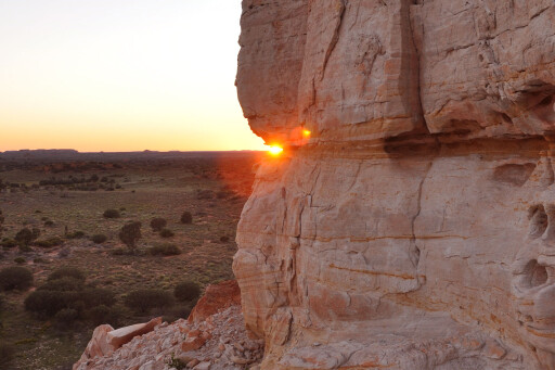
Onwards to the official campground. The next morning it was a case of the early bird gets the hot pie, with all meeting again at the nearby Docker River store. The final day of the desert stage was setting like the sun over the Olgas. We admired the spectacle of changing colours of the rocks and the sky, and eventually arrived at Ayres Rock campground a day early for the big meeting with family flying in for the return journey. Grand Final time saw plenty of refreshments; warm sunny days saw plenty of washing and visiting sights all Australians and, it seemed, a squillion overseas tourists,
strive for.
 We were lucky to strike the Rock on a ‘climb open’ day, so those that had not previously attempted it achieved their desires. We eventually departed on schedule for Kings Canyon and the Mereenie Loop Road and all the sights that afforded – Redbank and Ormiston gorges are the pick. We nipped off for a brief overnighter in the Alice, before heading down the Old Ghan Railway to Chambers Pillar and Lamberts Centre. Then it was out to Mt Dare and the very refreshing Dalhousie Springs. We returned to the track on ever-improving roads, to Oodnadatta and yet another Grand Final to finally to get a buzz at Mosquito Junction. Never heard of it? Well, after recent rains, we have decided to rename North Creek on the old Ghan. They were vicious and had no respect for Aerogard whatsoever!
Our last days travelled a very congested Oodnadatta Track, with fleets of fourbies with camper trailers, and many Britz rental vans. The scenery (in particular the Flinders Ranges) was in full bloom. Who said we were in a desert country?
A must do in the Southern Flinders is to get your kicks at Wilmington Toy Museum, (not on Route 66, but on B56!). For the family oriented, you cannot go past the Pichi Richi Camel Farm. My daughter finally satisfied her whim for a ride on these savage beasts. Just ask for Feral!
 Most of our shineyside contingent departed for a faster route home via Broken Hill, while the two Jeeps wandered up the Murray to meet an intrepid group of four GPAs (amphibious Jeeps – see 4X4 Australia July 2010 issue for the Corowa Swim In story on classic Jeeps) heading down the Murray. After a night of story swapping, we did the final 720km leg to our loved ones who had not seen us for six weeks.
So, where to next?
Travel Planner:
When to Go
Late autumn, winter or early spring, when it’s cooler.
Distances
From Coober Pedy Ilkurlka is 811km and Warburton is a further 530km. Then it is 320km to Warakurna via the Gunbarrel Highway, 340km return to visit Surveyor Generals Corner and 340km via Docker River to Uluru. Fuel can be pre-ordered at Ilkurlka on 08 9037 1147.
Driving Time
Allow as much time as possible. Some recommend five days from Coober Pedy to Laverton in WA. We allowed six to Ilkurlka and another three to Warburton. Due to conditions, we took 11 days.
Supplies
Coober Pedy, Ilkurlka, Warburton, Warakurna, Docker River and Uluru.
Difficulty
Moderate, mainly due to distance and the relentless corrugations. However, rain changes everything.
Advice
Don’t take a trailer.
Camping
Restrictions at certain places, as will be highlighted on your permits. Please respect them.
Further Information
Hema Maps have excellent information and phone numbers. We found Len Beadell’s books invaluable. See beadell.com.au.
Please enable JavaScript to view the comments powered by Disqus.
COMMENTS