Explore WA
Gallery27
After sailing beside the treacherous Zuytdorp Cliffs and the rugged west coast, Dirk Hartog anchored in Turtle Bay, a sublime anchorage sheltered from the southern swells. Here he climbed the dunes to consider the view from the top of the cape; to the north and east he saw only the vast open ocean and must have assumed he had reached the western edge of the great South Land, or that he was on an island.
Standing on the same point as Dirk Hartog some 400 years later, on an extremely hot and clear day, I peered east and caught the faintest glimpse of a strip of orange floating on the horizon. Having been to Cape Peron, I knew this mirage on the ocean was orange dunes, some 40km away. If Dirk Hartog had glimpsed this phenomenon all those years ago, I wonder if he would have set sail to explore Shark Bay to the east. Instead, after three days, he left a plate with an inscription on what is now aptly known as Cape Inscription, and left for Batavia.
27
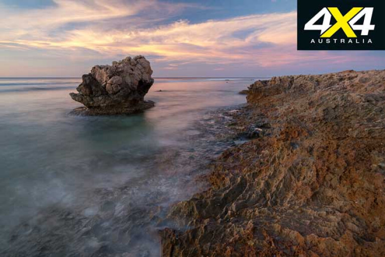
Dirk Hartog Island (DHI) is a finger of land that protects Shark Bay. The island is 76km long and averages about 11km wide, but just 3km wide at it’s narrowest point. It’s the largest island in Western Australia, and it has a diverse coastline with 200m-high cliffs, blowholes, sand dunes, coloured lakes and calm bays that offer a myriad hue of blues. The abundance and variety of fish around the island is incredible.
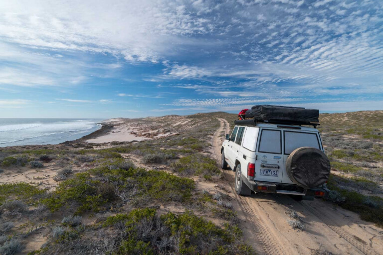
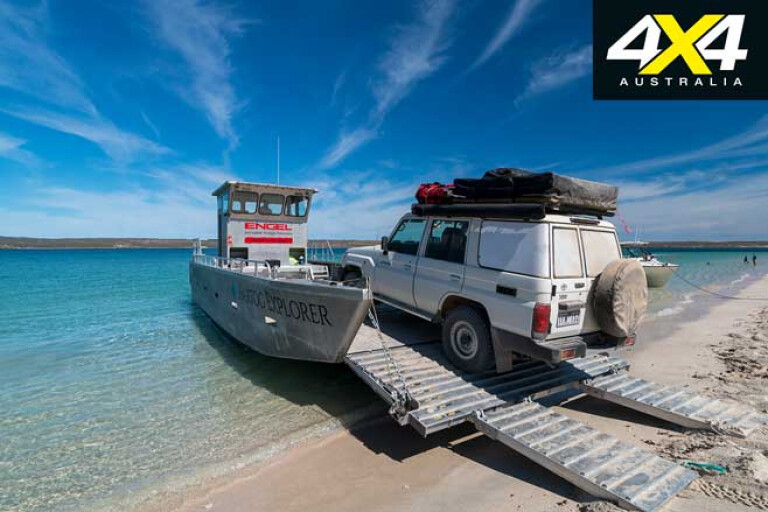
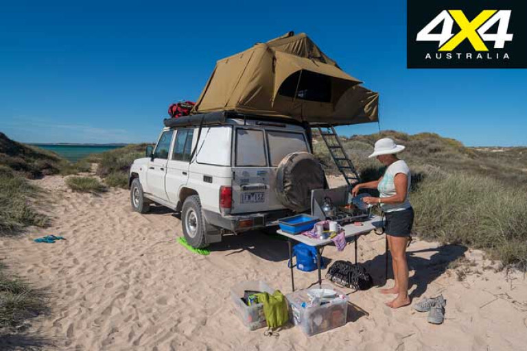
The camping on DHI is superb – and exclusive – with no more than 20 vehicles permitted at any one time, and visits must be pre-booked. It’s possible to fly or barge over to the island from Denham, but if you want to take your vehicle across you will have to put it on the barge at Steep Point.
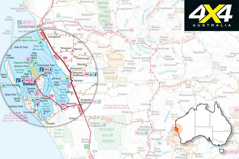
The Overlander Roadhouse, 700km north of Perth on the North West Coastal Highway, is the turnoff point for Shark Bay, and while it’s possible to reach Steep Point from here in just a few hours, there are a few destinations on the way that are worth extending your trip for.
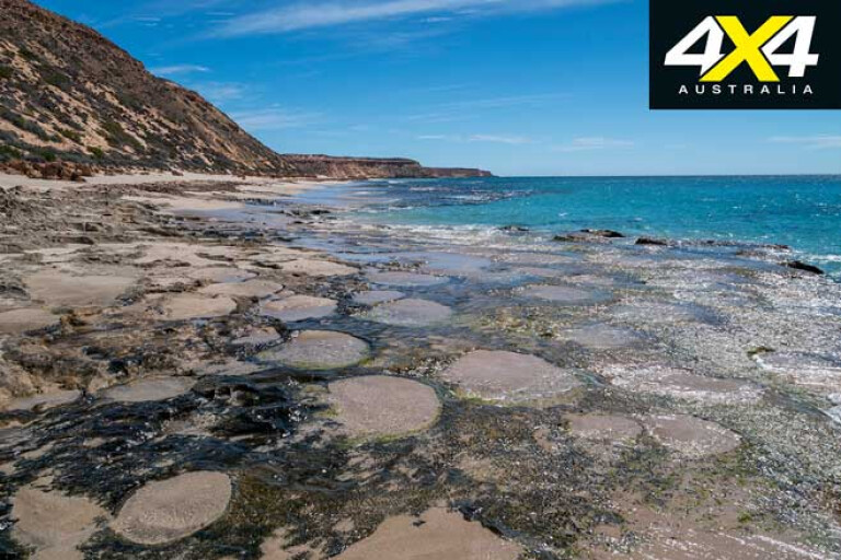
About 40km from the turnoff is Hamelin Pool and the stromatolites. A boardwalk here allows you to look at these ancient lifeforms, representative of life some three billion years ago. Facilities here include a small shop and a caravan park, and there’s the old telegraph station that houses artefacts from the early days of settlement.
27
The bitumen ends about 20km west of the turnoff to Denham and Shark Bay. A gravel road leads out to the salt works at Useless Loop, which is on the Heirisson Prong, a peninsula that juts out into the waters of Shark Bay. Useless Loop is a company town with a solar salt mine, and while you can’t see much of it as you drive by, these salt beds look stunning from the air with pools of different colours.
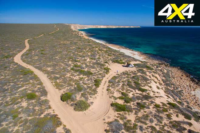
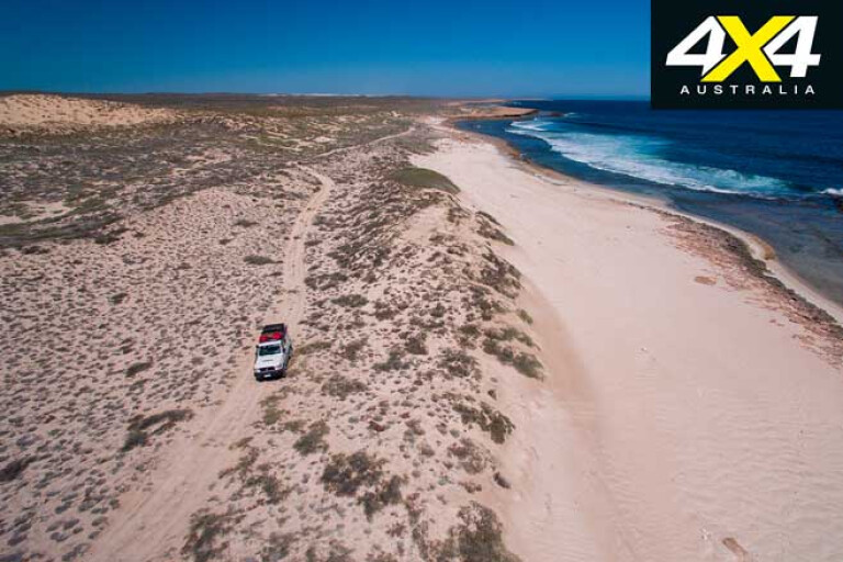
After Useless Loop you reach a junction; turn right for Steep Point and left to False Entrance, which is a gap in the Zuytdorp Cliffs. This gap was named False Entrance after being mistaken for South Passage, and the track to this site is well-formed but turns to soft sand as you approach the beach.
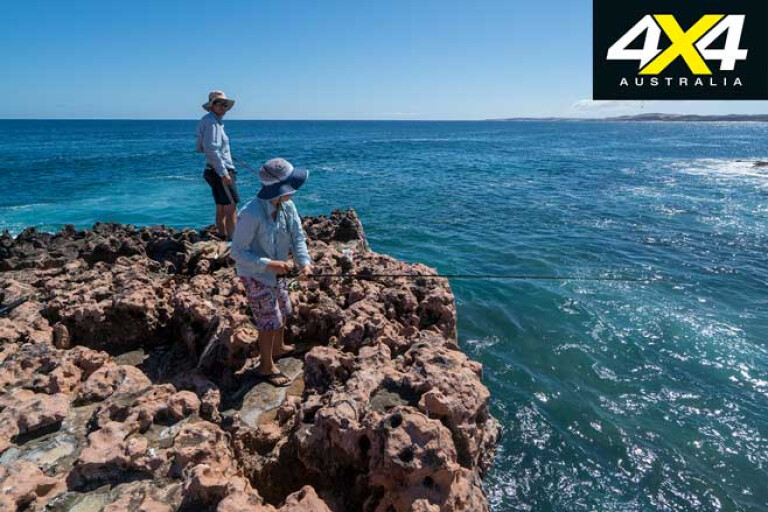
This is an ideal spot for fishing and beachcombing, and there’s plenty of ocean life about including sharks and manta rays. There are also blowholes in the cliffs and, for those who want to spend the night, informal camping.
27
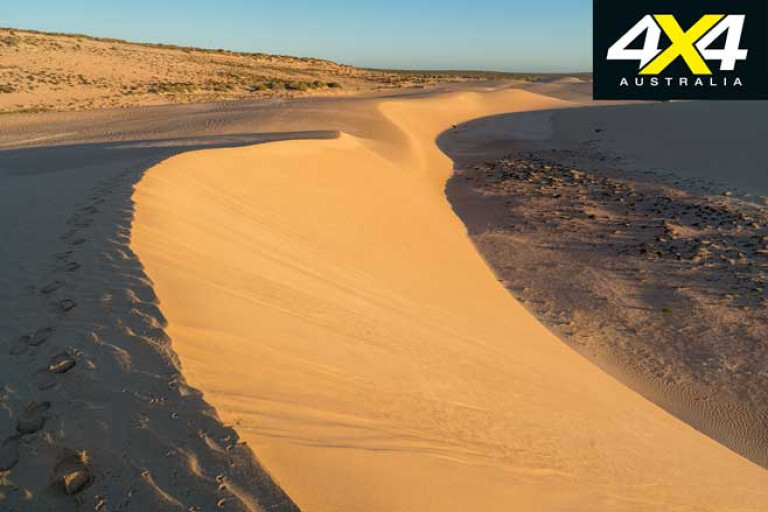
At the base of the hill on the Steep Point track is a sign that reads “4WD access only and please deflate your tyres to 20psi”. The climb here is the worst section of the track; you have to climb up and down dunes and the track itself is very narrow, the sand is soft and it’s likely you’ll meet oncoming vehicles, some towing boats.
The track winds through picturesque dunes and eventually you reach the beach at South Passage. Here you can check in to the Ranger’s House or book your camping for the night. There are many campsites along the beach here at South Passage, the water is clear and blue, and the fishing is great. Pull out a chair and sit back with your rod in the water; I caught a massive spangled emperor from my campsite on the beach.
27
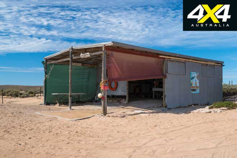
The barge, which can carry a 4x4 and camper trailer, pulls up at Blackies Beach about 600m west of the Ranger’s House. The crossing to DHI is only about 15 minutes, but it’s enough time to get out and have a look around. The barge lands at Cape Ransonnet and by the time you arrive here you should have already booked your campsites. There are national park campsites around the island, which are all bush or beach camping.
The southern part of the island has some tracks leading to amazing features: near Cape Ransonnet the white dunes meet the sparkling blue waters of South Passage; and on the west coast is Surf Point, where you can take in a magnificent panorama of the island from the rocky headland overlooking the surf and Steep Point on the mainland. You can walk through the shallows here and watch the amazing marine life, including hundreds of small sharks.
Farther north the track heads over the dunes to some tall and dramatic cliffs, and there is a giant blowhole nearby that in huge swells sends spray towering overhead. The rock shelfs are good for experienced fishers.
27
Just north of the Homestead is Tetrodon Loop, which is a bay that’s encircled by Quoin Bluff South and Notch Point. Tracks up to these points provide high views across Shark Bay. From Quoin Bluff we watched small sharks circle a cormorant roost, and you will often see tiger sharks cruising in the shallows as well. To the west are some of the largest dunes on the island, as well as Cliff Lookout which is the highest point on the island.
There’s beachside camping at Homestead Beach, with facilities and a camp kitchen. Most of the campsites are in the northern part of the island, so it can be worth staying at Homestead Beach for a while if you want to explore the southern section. It’s a great place to stay before leaving the island, as many return transfers are in the morning.
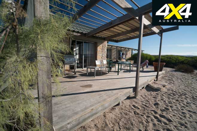
The homestead also offers accommodation at the Ocean Villa, which is a self-contained cottage at the water’s edge, or in the Eco Lodge, which is the original homestead and has six rooms, all fully catered. It’s a stunning spot right on the beach – one of those first class eco-stays that attracts people wanting to escape the ordinary.
27
From Dirk Hartog Island Lodge the track winds up the east coast of the island and is mostly a hard surface with some corrugations and soft patches. It will take between three and four hours to reach Cape Inscription from the barge landing, and on the way you will pass some amazing sights including red and pink salt lakes.
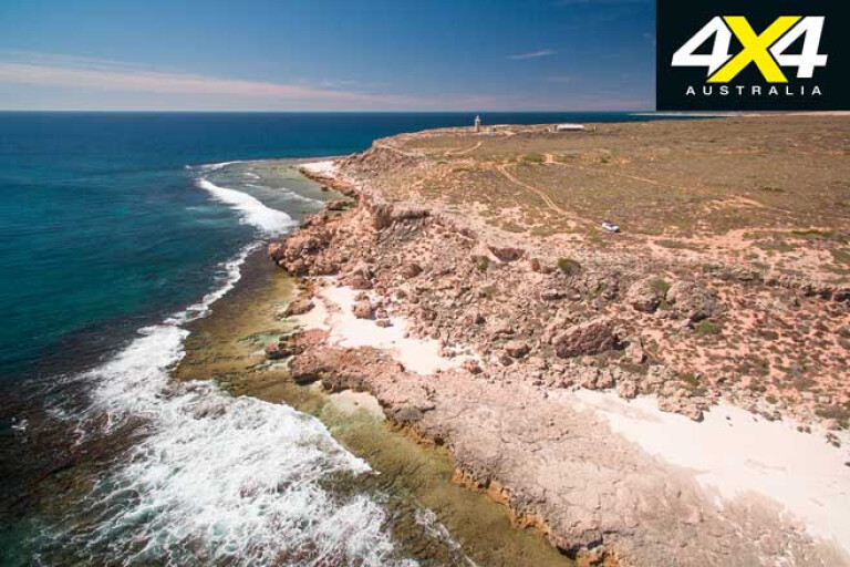
The lighthouse and keeper’s quarters are among few manmade features on Dirk Hartog Island. These were built at Cape Inscription between 1908 and 1910, and here you’ll find a plate that commemorates Dirk Hartog. On the beach below are the remnants of an old jetty.
27
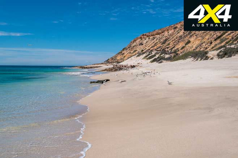
The headland is great place to explore; below the lighthouse there are interesting rock pools and to the east you’ll find the stunning expanse of Turtle Bay that stretches about 6km towards Cape Levillian, the north-eastern point of the island.
About 20km south of Cape Inscription, on the west coast, is Mystery Beach. This is a great day trip from the northern campsites, and the spectacular drive south winds through dunes near the beach. Mystery Beach was named after a mystery shipwreck, and it’s littered with natural sponges, driftwood and all sorts of flotsam. The sand on the beach is very soft, and impressive dunes near the cliffs make for interesting walks.
Camping
27
The national park campsites on the island are spread between the east and west coast, and they are all near the water and offer very different experiences. The winds are predominantly from the southwest so the east coast is quite sheltered, offering flat water in shallow bays and making it good for paddle boarding, snorkelling, kayaking or putting in a small boat. The west coast is rugged with wild swells and scenery to match, mostly rocky shorelines and spectacular fishing. The national park campsites have no facilities.
Turtle Bay Campsite is about 4km east of Cape Inscription. It’s a single site right on the edge of the cliff above the eastern end of Turtle Bay, which is the largest loggerhead breeding colony in Australia. In summer the turtles nest on the beach, and even as late as April there are still stragglers coming ashore. There is a short but steep track down to the water and it’s a great place for a beach walk and a swim. It’s mesmerising just looking out to sea, waiting to spot dolphins, whales or sharks.
27
Urchin Point Campsite is about 4km from Cape Inscription on the west coast. The site is on a platform cliff shelf above the ocean. There is a shed/shelter here which provides shade and protection from strong winds, and a small stretch of sand is good for fishing with floats or lures due to the rocky bottom. There is a left-hand surf break here as well.
The Block Campsite is on the west coast about 6.5km from Cape Inscription. It’s named after a large and bizarre rock that’s shaped like a large cube, which was washed up in a tsunami. The site is set on a rock shelf that drops steeply into the ocean, and it’s well-suited to cliff fishing but not for swimming as the swells break right onto the rock ledge. The site has a shed and can be booked for up to four vehicles. If fishing isn’t your main interest it’s still a good site where you can make a more permanent type of camp, and is not too far from Cape Inscription.
27
Dampier’s Landing Campsite is about 6.5km east of Cape Inscription. It’s a single site for up to three vehicles and is positioned right near a beach on the west coast. The sand is part of a spit that points out at Cape Levillain, and is pure white and very fine, hence very soft for beach driving and not recommended for trailers. This is where William Dampier landed in 1699 and named Shark Bay, and there is a plaque here to that effect. The beach has fish and turtles that swim close to shore, and there are hundreds of crabs scurrying about.
Withnell Point Campsite is about 16km south of Cape Inscription on the east coast. It’s a sandy point on a large bay and can accommodate three separate group bookings. It’s right on a flat, shallow and safe beach, and it’s great for small kids and beach fishing.
27
Sandy Point campsite is about 32km south of Cape Inscription on the east coast. It’s near a flat, sandy beach and is good for beach fishing or launching a boat. Offshore there’s a coral reef that’s located in a sanctuary zone.
Quoin Head is located on the western side of the island near it’s midpoint, and it’s a 17km drive across the island from Sandy Point. The campsite is on a rocky ledge above reefs and shelves, and while excellent for fishing it’s not easy to access the water. It’s near Charlies Harbour which has inspiring cliff formations, and you’ll be able to spot an osprey nest on top of one rocky outcrop. Campers here try their luck with balloon fishing for pelagic species like mackerel, as the winds will take your line out into bay.
Louisa Bay campsite is on the eastern side, another 10km south of Sandy Point. A single site that can take up to four vehicles, the bay has a sandy beach with shallow waters and is a great sheltered site suitable for fishing and snorkelling. You can launch small boats and kayaks from the beach here, and there are coral reefs offshore with reef fish.
Fraser Comparisons
27
It’s inevitable that Dirk Hartog Island will be compared to Fraser Island; both are amazing 4x4 locations and DHI is definitely the west coast equivalent. However, it’s the remoteness and exclusivity of DHI that makes it worthy of its bucket-list status. It’s a big island with diverse opportunities and the marine life here is amazing and very easily seen, with sharks on the west coast and dugongs on the east.
You feel the remoteness here, too; although, you’ll frequently spot sea eagles, osprey and other birdlife. DHI recently became a Wildlife Ark, with native species released after feral cats and goats were culled. In the future, a camping trip here could also include sightings of rare animals like the chudditch, dibbler or boodie.
Travel Planner
27
It takes quite a bit of commitment to get to DHI, and the people who do often make return trips. While you can enjoy just a few days here, if you take a week or more you’ll be able to explore the north and south of the island. I found it easy to travel simply with a rooftop tent, and as it’s one of the best fishing locations in Australia, you can always catch a fish or two to stretch your supplies.
WHERE
On the western edge of Shark Bay, 700km north of Perth. Access is from Steep Point, a three- to four-hour drive from the highway. From here take the 15-minute barge across South Passage to DHI.
DRIVING CONDITIONS
Many of the tracks on DHI are well-formed but there are soft sections, particularly on the entry and exit points near the barge, and on the beaches. Access to Steep Point and DHI is all sand so it’s only suitable for 4x4s. Tyre pressures need to be dropped, and there are some very soft sections out to Steep Point and on DHI, so recovery gear such as tracks and shovels should be carried. You need to be fully self-sufficient.
CAMPING
Camping on the island is all basic – there are no facilities – and you need to bury your waste. There is no water, so you must bring all supplies if camping in the national park. Some sites are exposed so you need plenty of water and shade. Be prepared for strong winds. There is camping available at Homestead Beach, with some facilities.
PERMITS
Camping must be pre-booked through the website. Accommodation at the homestead also needs pre-booking. The barge transfers also need to be pre-booked.
CONTACTS
See www.dirkhartogisland.com for camping permits and barge transfer bookings.
Department of Parks and Wildlife – Shark Bay District
Address: 61–63 Knight Terrace, Denham, WA, 6537
Phone: (08) 9948 2226
Email: sharkbayenquiries@dpaw.wa.gov.au
Website: www.sharkbay.org; www.dpaw.wa.gov.au
Steep Point Ranger Station
Phone: (08) 9948 3993
Email: ranger@steeppoint.com.au
Please enable JavaScript to view the comments powered by Disqus.
COMMENTS