Explore WA
Gallery1
How does the saying go: ‘Up shit creek without a paddle?’ I was, in fact, in shit creek, up to my crutch in quicksand, and the slop was getting deeper as I tried to drag my feet from the suction of the sand.
That wasn’t working real well, so I threw myself down as flat as I could onto the slurry and wiggled like a demented snake, trying to keep my camera gear out of the muck around me. A minute or so later (it seemed longer!) I was on dry land again, thinking, jeez, that was fun, or thoughts to that effect.
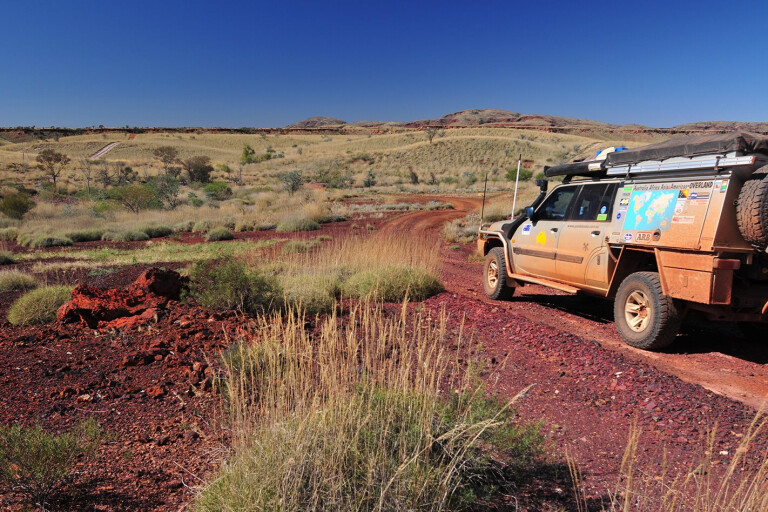
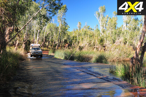
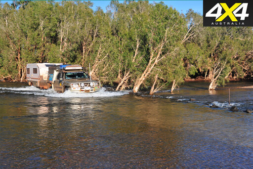
We were on our way to Coppin Gap, north of Marble Bar and south of the deserted township of Shay Gap, and had stopped to take a photo of the Nissan Patrol and Trakmaster camper going through a shallow creek. It wasn’t deep, but flowing water in the Pilbara is always nice, so I’d wandered upstream to find a spot I could step across without getting my feet wet. However, I soon found myself in strife. Quicksand is probably the last thing to expect in the Pilbara.
 A few minutes later, I was standing in the creek at the crossing, stripped off, washing sand from clothes, boots and other places, when the only vehicle we had seen for two days came along. The women laughed as they drove by... why? I didn’t think it was that funny!
We had been wandering around the Pilbara for a few weeks by then, with our journey this time beginning as we headed inland from North West Cape and the coastal delights of Ningaloo to find quieter, more remote places to enjoy.
At the relatively small mining community of Paraburdoo, we stocked up with supplies and then tried to get to Ratty Pool, which is, from what we were told, west of the town, through a narrow gap in the rocky range. We didn’t find it, but we did discover a natural spring that was gushing water. After spending a few hours floundering around on the track, which was really a fast-flowing creek, we gave up and camped nearby on higher, drier land.
 Not to be perturbed, we went looking for another gem a friend had told us about. This one was east of town, tucked into the hills in a rarely visited far-south-west section of the Karijini National Park. Most people know Karijini from the magnificent gorges that can be found in its far-northern section (more on them later) but only a few locals know of the hidden delights elsewhere in the park, one of those being Bobswim Waterhole.
The main road between Paraburdoo and Tom Price basically follows the iron ore railroad. About 30km north of Paraburdoo, you take a dirt road south-east past Mallee Station, a siding on the rail line. About 8km along this dirt road from the siding, you turn on to a well-used track that strikes east across rolling hills covered in spinifex and dotted with scrub, with small ephemeral creeks lined with green, spindly trees. It’s not a particularly hard or difficult track. If you have a camper trailer on the back, as you get close to Bobswim, about 25km from the blacktop, it gets a bit tight and steep in one or two places – don’t get caught out!
 Bobswim is a picturesque stretch of water in Turee Creek, the impressive creek and tributary of the mighty Ashburton River. Bordered by low, red cliffs on one side and lined by shady gums on the other, the waterhole is a permanent oasis in a rocky and often heat-blasted, dry landscape. It’s a top spot to camp and, while away a couple of days or more, there are more tracks to explore and waterholes to discover.
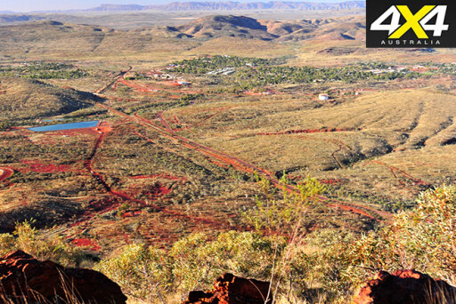
Once we tore ourselves away, our next stop was Tom Price, a town we hadn’t visited since the mid-1970s. A 4WD track up nearby Mt Nameless attracted my attention. That evening, we sat on the mountain’s lofty crest as the sun made tracks to the horizon. The town has become a little bigger than it was in the ’70s, but the mountain that feeds the mine has shrunk quite a lot. One day in the not-too-distant future, Mount Tom Price will be a hole in the ground.
 Resupplied and with a dose of civilisation behind us, we headed north into Karijini NP, checking out a few of the gorges, but it was getting to the end of the school holidays and the park was crowded with visitors.
The difference from Bobswim was stark – we had only seen one other camp at Bobswim and that was a group of local motorbike riders exploring the area. We thought of going back but, with the holidays ending in a day or two, we opted instead to head for the Millstream Chichester National Park and Gregory’s Gorge, which is just outside the park.
But I was stymied again! Access now to the gorge – an important cultural place for the local Aboriginal people – is only granted from the north, via the Ngurrawaana Community, where you pay $15 to the ranger and get directions into the gorge camping area. So close yet so far. It is a top spot – just don’t try to get there from the Millstream end.
As it was, we stopped a couple of nights in the national park, but I wasn’t impressed with either of the camping areas that have been established since camping was stopped at Deep Reach Pool and Crossing Pool.
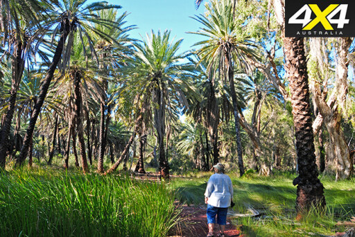 After a bit of walking among the palms and beside the flowing channels of the Fortescue River, we moved on, heading back to the coast for a change of scenery. We hoped, with the school holidays now over, the coast would be a bit quieter.
We first checked out the mouth of the Fortescue River, the turn-off being about 30km north of the roadhouse of the same name. The access road passes the massive Sino Iron project, one of the biggest developments on the WA coast and, although it’s ugly, it’s pretty easy to ignore once you’re at the mouth of the Fortescue. There’s a rough boat ramp here and it’s popular with long-term campers, with most of them camping 1km or so inland, away from the mangroves, mozzies and sand flies.
Those who visit come mainly for the fishing, as there are no long-term attractions for anyone else. Still, it’s not a bad spot to spend a day or so, even if you don’t throw in a line or launch a boat to go fishing and snag some dinner.
 Next was a stop at 40 Mile, or Gnoorea Point, another popular long-term camping spot about 55km south of Karratha. Again, there is an industrial complex – a gas plant – you pass just as you turn off the highway, but you can get fresh water here from a tap, which happens to be the closest good water to 40 Mile. Camps are generally spread out along the coast south of a boat ramp and, like at many places on the west coast, you need a chemical toilet (a portable toilet is fine) to camp here.
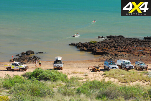
Our stay at 40 Mile wasn’t long and we headed north, stopping a few days in Karratha to stock up and experience the historic Cossack port and the Burrup Peninsula. Now the Burrup is home to one of the greatest industrial developments in Australia, but it also has Australia’s (some say the world’s) largest collection of petroglyphs, or Aboriginal rock engravings, dating back probably 20,000 years or more. It also has a couple of superb beaches, all of which are accessible with a four-wheel drive vehicle.
 Deep Gorge, with its ancient art sites, is easily reached and, with a bit of walking, many petroglyphs can be found here. A little farther on is Hearson’s Cove, a sweep of beach that is best appreciated at high tide. A rougher 4x4 track heads farther out past the gigantic gas processing plant and flaring towers and skirts along the short beach of Withnell Cove.
It then gets to a thin line of mangroves, a normally shallow water crossing and a challenging climb up a rocky jump-up. It continues to the shores of Searipple Passage at the end of the Peninsula, but you have to be keen and have a well set-up truck to tackle the aforementioned rock-strewn climb. Much of the area is now protected in the 50km² of Murujuga National Park, which was declared in early 2013 and leased back from the traditional owners of the land.
Next stop on our whistle-stop tour of the coast was Cleaverville, a beach-side camping spot about 25km north of Karratha. This is our favourite spot along this section of coast and it is popular with many long-term campers. Like at 40 Mile, there’s a caretaker and a fee payable, but here it is easier to get a site to yourself. You can launch a small tinnie off the beach at a couple of spots here as well, but the rocky coastline along the northern point, jutting into Port Robinson (with Dixon Island offshore), can produce fish for the shore-based angler as well.
 With itchy feet, we pushed north, stopping at the famous Whim Creek Hotel, built in 1897 and retaining much of its historic character. This had been closed to the general public for a few years because of nearby mining operations but, as of mid-2015, it has been reopened to the public. Don’t miss it!
From here a track heads west past the old historic Whim Creek Cemetery, which has graves dating back to 1894, to Balla Balla, a copper mine port back in the 1880s. The old port site seems set to become one of the newest iron-ore export facilities on the WA coast – but only if the price of ore improves, I’m guessing.
Still, at the time of our visit you could camp right on the coast, close to the mangroves and the rough boat ramp, or a few kilometres inland along Balla Balla Creek, in the vicinity of Coorinjinna Pool. The pools along the creek weren’t extensive when we were there. They dry up under the unrelenting sun, so don’t expect to get potable water from them, unless you are really bloody thirsty!
 Cruising north on the highway, we wanted to head for the mouth of the De Grey River and the old Condon Landing site. Once again, though, we were stymied, this time by heavy rain. On the phone with the surrounding property owner, we were asked not to use the tracks as the route cuts across some low-lying country bordering the coast for quite some distance.
We turned inland, hoping for better luck, passing the 50 or so vans camped at the highway crossing of the De Grey River (free camps are not our scene at all). We followed the De Grey upstream, finding a couple of spots to camp along its verdant banks.
We checked out Doolena Gap, an uncrowded spot where the Coongan River cuts through the rocky Gorge Range, but it was early in the day, so we pushed on, crossing the Coongan on the Bamboo Creek Road.
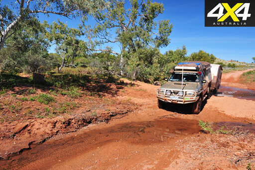
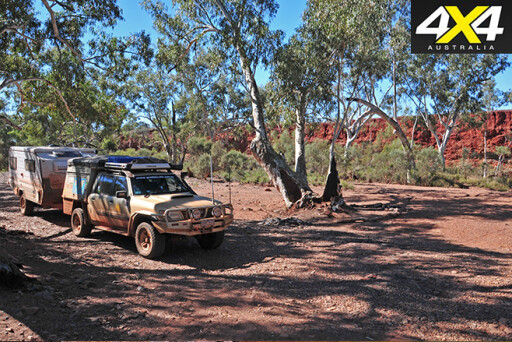
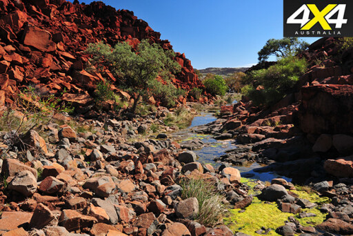
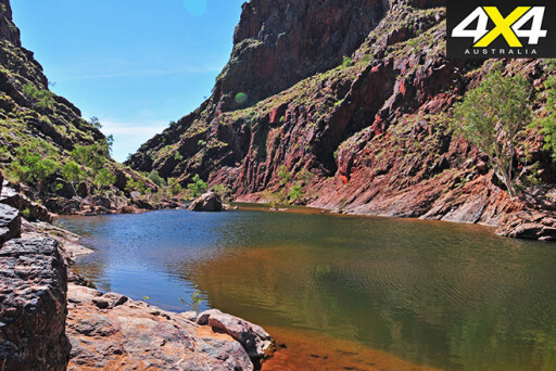 It was while travelling from here to Coppin Gap that I had an inglorious and naked meeting with a couple of other travellers. But I soon forgot my discomfort when we got to Coppin Gap. A relatively small creek has cut its way north through the rocky range here, leaving an idyllic permanent pool that entices wildlife and people to its cliff-lined shore. We stayed for a couple of nights, enjoying the tranquillity and doing a bit of exploring. But the recent rain had knocked the 4x4 tracks around; all were badly eroded.
From here we headed north along the Shay Gap Road, passing more small mining operations before again coming to the De Grey River. The wide, shallow crossing was busy with trucks and excavators as Telstra engineers were working on re-establishing the optical cable connection across the river. A recent flood had washed away the previous cable. So much for being in wild, remote country!

Our time in the Pilbara was drawing to a close, but we’ll be back to see the spots we missed because of weather and changed entry conditions!
TRAVEL PLANNER
‘Explore the Pilbara in your 4WD’, is a great little book for discovering the region, published by Westate Publishers – find it on the web for around $20.
For general travel and camping info on the region, as well as info and permits for the Rio Tinto Rail Access Road and the Burrup Peninsula, start at the Karratha Visitor Centre.
Please enable JavaScript to view the comments powered by Disqus.
COMMENTS