Explore QLD
Gallery43
A good day’s drive north-west from Brisbane led us to the small town of Taroom in Central Queensland.
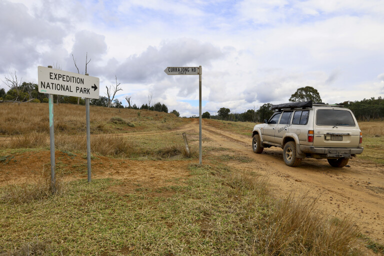
Today, Taroom is a rural town servicing the many properties in the Banana Shire, but it’s the gateway for us in to Expedition National Park.
Taroom’s claim to fame is that in 1844 Prussian explorer Ludwig Leichhardt marked a tree as LL44 when he was in the area. The tree is in the main street, yet the markings have since grown over and trying to decipher it can be a little difficult. Leichhardt was on his way towards Darwin from the Darling Downs area near Brisbane, opening up new pastoral land. He discovered and named the nearby Dawson River as well as Expedition NP.
43
Another feature in Taroom is a rare windmill made around 1900 by the Steel Wings company in Sydney. The windmill has a rare steel frame holding up the blades that was supported by a timber frame. This one at Taroom came off a property nearby and was in service until late 1950.
Unfortunately, a fire burnt the base and caused it to collapse, but it was moved to town and restored in 2003. There are now only two examples of this windmill left in the world.
Detouring
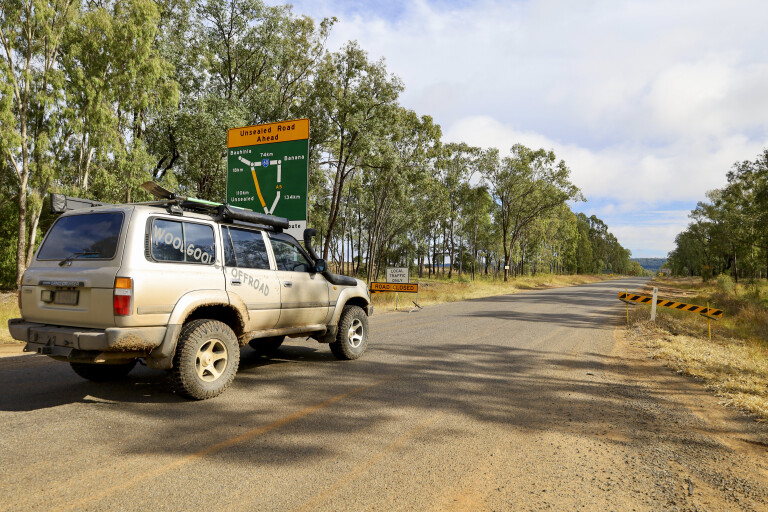
There are several ways into Expedition but our entry to the park was halted at the Glenhaughton Road section due to recent heavy rainfall closing the roads, but we found Bradmere Road was open and it detoured around the flooded lakes and road sections.
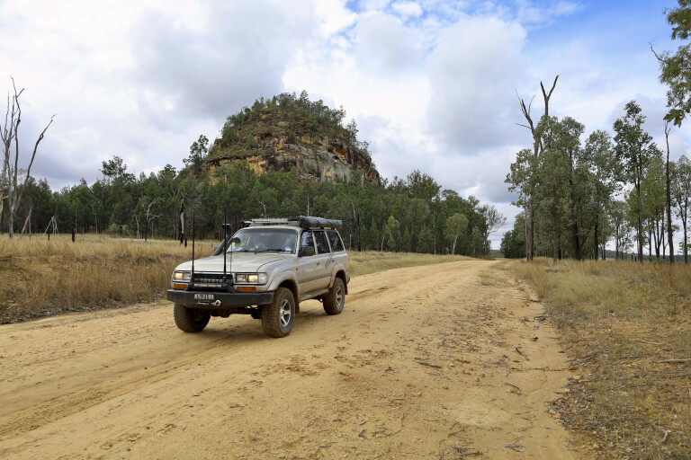
The main features of the park are found as you head towards Robinson Gorge, with high sandstone cliffs, stunning gorges and a river lined with Dawson River palms. Other options to enter the park include from the Beilba and Lonesome sections, where both provide different views across the ancient landscape.
43
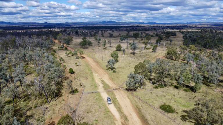
Our plan was to find the remote Starkvale Creek campsite within the Robinson Gorge area, explore the Cattle Dip gorge and find the heritage cattle yards along the way. Joining back on to Glenhaughton Road past the flooding, we stuck to the main road that passed through cattle stations and eventually led to Expedition.
The final road to Starkvale was well-signposted, but it’s 4WD only for the last 16km. Midway along we found the old cattle yards and took time out to wander around, checking out the build quality which was all held together with wire and interlocking poles.
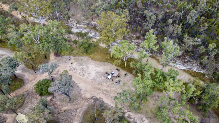
The Starkvale campground along the side of the creek has to be one of the best I’ve come across. Clean, plenty of room, and some pretty flash toilets. This is remote camping, so make sure you’re totally self-sufficient here.
43
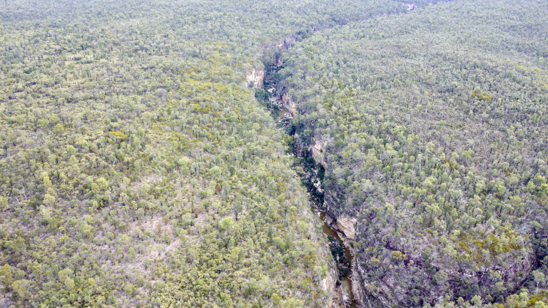
A track just near the campground takes you across to Cattle Dip in Robinson Gorge where you have stunning views down to the water-filled rock areas. The track to the parking area of the gorge is at times low-range 4WDing with several steep sections, but the gorge walk is well worth it.
If you’re keen for a hike, you can tackle either the Robinson Gorge Lookout walk, the Gorge access track, Shepherds Peak track, or walk to Cattle Dip. A detailed info board is a must-read before you do any of these, for your safety.
Sandstone country
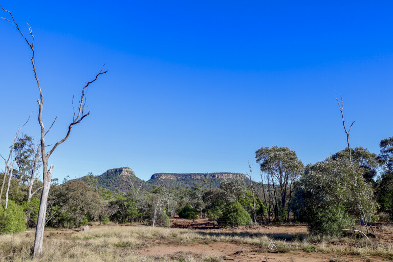
Through Central Queensland this area is known as sandstone belt country and covers at least 82,000km². The varied landscapes were formed by millions of years of uplift, where huge sheets of sand that were deposited 190 million years ago have worn away to leave tough basalt rock formations. This wild landscape is a result of a long and turbulent geological history.
Today, we are left with a complex of scenic gorges, waterholes and springs, and the park conserves a range of plant communities and threatened animal species. The park is home to 10 different species of animals that are classed as ‘vulnerable to extinction’, and some of the bigger rock plateaus are more than 1000m high and have earned the nickname as ‘the roof of Queensland’.
43
After Leichhardt went through, the settlers and pastoralists moved in causing decades of conflict with the local people, and by 1920 European diseases took their toll and the remaining Aboriginals were forcibly moved out.
Formed in 1852, Glenhaughton sheep station covered all of the NP and surrounding forests. At one stage the station employed more than 50 shepherds to look after the sheep, but by the late 1890s the sheep were replaced by cattle. Old shepherd hut ruins and their sites can still be found throughout the park.
43
After an extremely quiet night at camp, we decided to head up through the park along the Robinson Gorge track and to the north. Signposted as ‘slippery when wet’ was a good intro to the track as it was low-range 4WD for its entire length. There are a stack of creek crossings, as well as rutted and narrow roads, and towing a large trailer through here is not recommended.
The plan was to cut across Oil Bore Road towards the wetlands of Lake Nuga Nuga in the Arcadia Valley. The lake is the largest natural waterbody in the Central Queensland sandstone belt, created 140 years ago when Browns Creek silted up. Today, it’s a natural haven for birds, water plants and more. There is bush camping on the lake’s shores, all overshadowed by Mount Warrinilla on the south-western end of the lake.
Lonesome
With a few hours under our belt counting numerous different bird species, we decided to keep heading up the Arcadia Valley towards the Lonesome section of Expedition NP.
It’s a spectacular drive through the valley, with the sandstone cliffs in the distance on both sides created after millions of years of weathering down the soft sands to leave behind only hardened rock. Like them or hate them, gas plants are scattered throughout the valley, pulling natural gas from the earth.
43
Our final camp was at the Lonesome bush camp area. There are no facilities but it’s easily accessible from Arcadia Valley road. Set high above the Dawson River and with high sandstone mountains above, it’s a beautiful setting to kick back and relax.
Sunrise on the high rocky cliffs with glowing colours from the ancient rocks is worth waking early for, but before leaving Expedition we decided to do a couple of loops around nearby plateaus.
By heading straight out of the camp and turning right, the loop around Mount Jiman is spectacular and we were graced by massive rock formations that are nearly 600m high – the vivid earth colours adorning the bare rock as we passed around the mountain.
43
Leaving the Mount Jiman loop, we followed the National Park boundary trail to the top of Karingbal Pass. This trail is 4WD only, with several steep pinches and a multitude of creek crossings. It’s well worth the drive, where you’ll see huge age-old bottle trees, a variety of bush settings and different cycad plants.
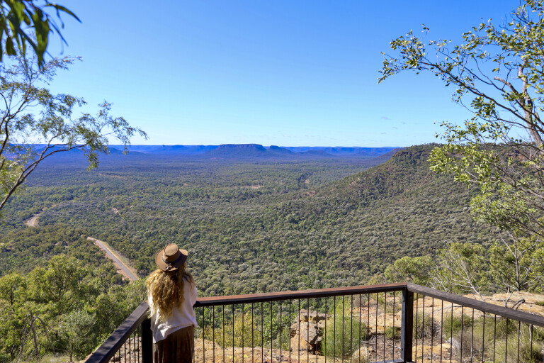
At the top of the pass, a quick turn right down to the Lonesome lookout will leave you with breathless views eastward through the beautiful Arcadia Valley.
Ideally, the perfect time to be here would be sunset, where rich colours light up the surrounding sandstone cliffs. Ending our exploration here, it was an unexpected surprise finding history, 4WDing and spectacular scenery through Expedition NP, where it often gets overshadowed by nearby Carnarvon Gorge.
It’s worth the effort if you have a few days on your hands when touring Central Queensland, to explore this ancient landscape.
Top five
Taroom
The RV Friendly Town of Taroom, 380km north-west of Brisbane, has plenty to offer tourers and makes a great base to explore nearby local natural wonders, such as Chain Lagoons, Expedition and Gorge NPs, Flagstaff Hill, Lake Murphy Conservation Park, and excellent fishing at Dawson River, Glebe Weir and Palm Tree Creek. Annual events are mostly dedicated to the horse and horsemanship with the Taroom Races, Golden Horseshoe Campdraft, Taroom Professional Rodeo, Polocrosse Club Carnival and Dawson River Festival.
Expedition National Park
Located 500km north-west of Brisbane in the heart of sandstone country, Expedition NP covers an area just larger than 1000km². Some sections are accessible by a 2WD vehicle, but for the full experience a 4WD is highly recommended. It’s a remote park so you’ll need to be totally self-sufficient.
What to see
Expedition NP is all about serenity, where hiking trails lead you through the park and to different features, with 4WD tracks to explore, remote gorges and waterholes shadowed by huge sandstone plateaus.
Where to stay
There are several official campsites at Expedition. Lonesome bush camp has no facilities and is accessible by 2WD, but the Starkvale campsite in the heart of the park is only accessible by 4WD but has toilets, fire pits and non-potable water. On the western side of the park, Beilba camping area offers remote camping away from the crowds. For the hiker, there are walk-in camping areas throughout the park. Bookings are essential online.
Other info and maps
Most relevant and up-to-date information can be found here and includes closures, park management programs, maps, camping info and costs. Taroom Visitor Information Centre has relevant info when open. It can be found in the main street of Taroom, phone (07) 4628 6113.
Please enable JavaScript to view the comments powered by Disqus.
COMMENTS